
Funkcje mapy, które możesz dostosować, są ułożone w hierarchii. Każda z nich ma co najmniej 1 element stylu, który możesz dostosować. Większość funkcji najwyższego poziomu ma co najmniej 1 funkcję podrzędną. Podczas dostosowywania stylów mapy masz kilka opcji:
Dziedziczenie stylu z podstawowego stylu mapy: jeśli nie dostosujesz elementu stylu dla funkcji mapy, odziedziczy ona domyślny styl z mapy bazowej.
Dziedziczenie z elementów nadrzędnych: dostosuj element stylu w przypadku elementu mapy nadrzędnej, aby wszystkie niedostosowane elementy mapy podrzędnej dziedziczyły style z elementu nadrzędnego.
Zastąpienie stylu nadrzędnego: dostosuj element stylu na mapie podrzędnej, aby zastąpić styl nadrzędny tego elementu.
Dostosowywanie poziomów powiększenia: w przypadku niektórych funkcji mapy możesz dostosować elementy stylu dla różnych poziomów powiększenia. Więcej informacji znajdziesz w artykule Poziomy powiększenia stylu.
Elementy mapy, których styl możesz zmienić
Elementy mapy mogą mieć co najmniej 1 z tych elementów stylu, które możesz dostosować w zależności od typu elementu mapy:
Widoczność: czy ta funkcja ma być widoczna na mapie.
Kolor wypełnienia: kolor wypełnienia wielokątów i polilinii.
Kolor konturu: kolor konturu wielokątów i polilinii.
Grubość kreski: grubość konturu wielokątów i polilinii. Wyniki mogą się różnić w zależności od poziomu powiększenia. Jeśli nie chcesz konturu, ustaw kolor kreski na taki sam jak kolor wypełnienia lub ustaw szerokość kreski na 0.
Kolor ikony: kolor wypełnienia ikon innych niż ikony punktów POI.
Kolor konturu pinezki: kolor konturu pinezek ciekawych miejsc.
Kolor wypełnienia pinezki: kolor wypełnienia pinezek interesujących miejsc.
Kolor glifu pinezki: kolor glifu pinezek ciekawych miejsc.
Kolor wypełnienia tekstu: kolor wypełnienia etykiet tekstowych.
Kolor konturu tekstu: kolor konturu etykiet tekstowych.
Widoczność elementu mapy
Ukrywanie elementów mapy lub sprawianie, że są one przezroczyste, może ujawnić niedokładności granic. Granice funkcji mapy nie zawsze są precyzyjne, ale są dostosowywane tak, aby wyglądały prawidłowo, gdy wszystkie warstwy są widoczne. Więcej informacji o tym, jak warstwy mapy wpływają na siebie nawzajem, znajdziesz w artykule Zarządzanie stylami, które się nakładają.
Istnieją 2 sposoby wyświetlania lub ukrywania elementów mapy: widoczność i krycie.
Widoczność
Aby wyświetlić lub ukryć element mapy, użyj elementu stylu Widoczność. Więcej informacji znajdziesz w artykule Filtrowanie wyświetlanych elementów mapy.
Nieprzezroczystość
Możesz też ustawić przezroczystość elementu mapy, dostosowując nieprzezroczystość tych elementów stylu: kolor wypełnienia, kolor kreski, kolor wypełnienia tekstu i kolor kreski tekstu.
Gdy dostosujesz krycie elementu mapy, jego wygląd będzie zależeć od elementów mapy znajdujących się pod nim. Aby uniknąć nieoczekiwanych zmian stylu, ustaw niestandardowy styl dla wszystkich nakładających się funkcji.
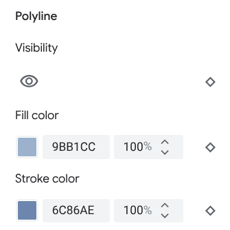
Wielokąty i linie łamane
W przypadku typów obiektów na mapie, które są reprezentowane przez kształt, np. plaża, kraj czy plac miejski, lub linię, np. tor kolejowy, autostrada czy szlak, możesz zwykle dostosować te elementy: widoczność, kolor wypełnienia, kolor obrysu i szerokość obrysu.
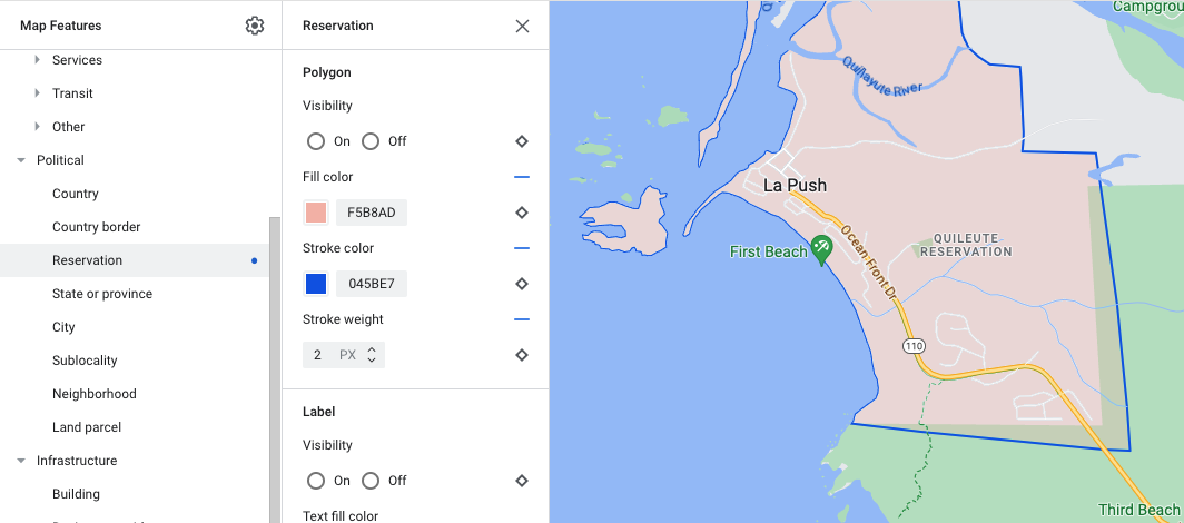
Przykład dostosowywania stylu wielokąta – dla typu obiektu Reservation
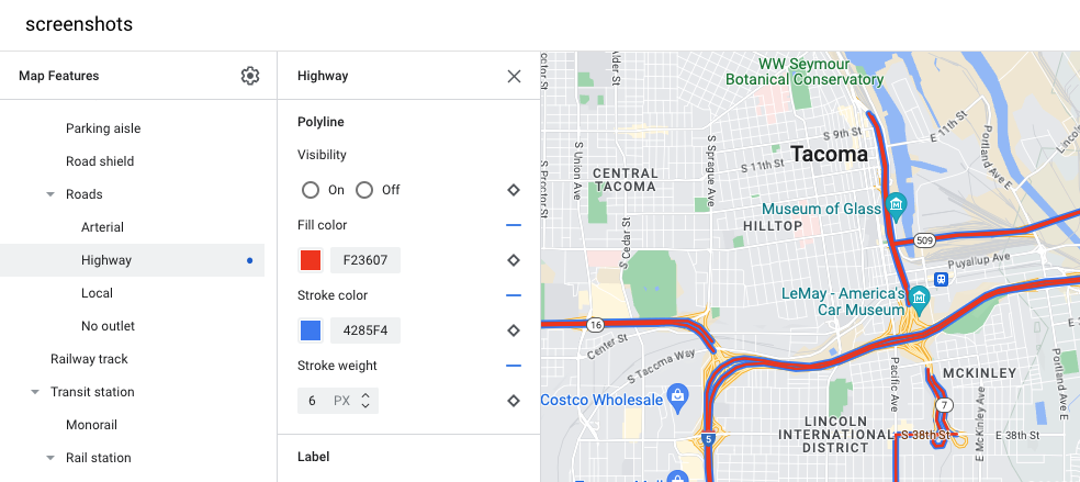
Przykład dostosowywania stylu linii łamanej – dla typu obiektu Autostrada
Dostosowywanie koloru i szerokości linii jest niedostępne w przypadku tych elementów mapy:
Elementy mapy politycznej: ich styl przekazuje znaczenie na mapie, np. wskazuje typ terytorium. Funkcje mapy politycznej to kraj, granica, stan lub prowincja i podregion.
Budynki w stylu 3D.
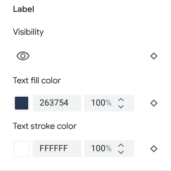
Ikony i etykiety tekstowe
W przypadku typów obiektów na mapie, które są w całości lub częściowo reprezentowane przez etykietę, takich jak transport i inne typy niezwiązane z punktami zainteresowania, możesz zwykle określić styl tych elementów: widoczność, kolor ikony, kolor wypełnienia tekstu i kolor obrysu tekstu.
![]()
Przykład dostosowywania stylu ikony i tekstu etykiety
Przypięte
Typy elementów mapy ważne miejsce możesz stylizować za pomocą tych elementów: widoczność, kolor obrysu pinezki, kolor wypełnienia pinezki, kolor glifu pinezki, kolor wypełnienia tekstu i kolor kreski tekstu.
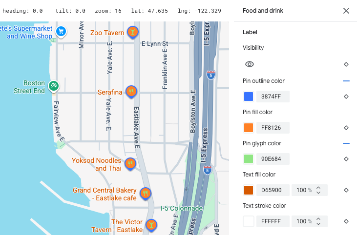
Przykład dostosowywania stylu pinezki i tekstu etykiety
Hierarchia elementów mapy
W tabelach dotyczących funkcji mapy najwyższego poziomu znajdziesz informacje o tym, jakie funkcje mapy podrzędnej są dostępne w ramach poszczególnych funkcji.
Ciekawe miejsce |
||
|---|---|---|
| Awaria | Straż pożarna Szpital Apteka Policja |
|
| Rozrywka | Sztuka Kasyno Kino Zabytki Muzeum Park rozrywki Atrakcja turystyczna |
|
| Jedzenie i picie | Bar Kawiarnia Restauracja Winiarnia |
|
| Punkt orientacyjny | ||
| Zakwaterowanie | ||
| Rekreacja | Plaża Pływanie łódką Wędkarstwo Pole golfowe Gorące źródło Rezerwat przyrody Park Szczyt Kompleks sportowy Boisko sportowe Początek szlaku Zoo |
|
| Handel detaliczny | Sklep spożywczy Zakupy |
|
| Usługa | Bankomat Bank Wypożyczalnia samochodów Stacja ładowania EV Stacja paliw Parking Poczta Miejsce odpoczynku Toaleta |
|
| Transport publiczny | Port lotniczy | |
| Inne | Most | |
| Cmentarz | ||
| Administracja państwowa | ||
| Biblioteka | ||
| Wojsko | ||
| Miejsce kultu | Buddyzm Chrześcijaństwo Hinduizm Islam Dżinizm Judaizm Shintoizm Sikhizm |
|
| Szkoła | ||
| Rynek miejski | ||
polityka, |
|
|---|---|
| Kraj | |
| Borders | |
| Rezerwacja | |
| Województwo lub region | |
| Miasto | |
| Dzielnica | |
| Dzielnica | |
| Działka | |
Infrastruktura |
|||
|---|---|---|---|
| * Funkcje mapy ze szczegółami dróg są dostępne tylko w usługach Google Maps Platform, w których włączone są szczegóły na poziomie dróg. Więcej informacji znajdziesz w artykule Szczegóły dotyczące poziomu dróg w Google Maps Platform. | |||
| Budynek | Komercyjne Wewnątrz |
||
| Dzielnica biznesowa | |||
| Sieć drogowa | Brak ruchu | Deptak handlowy | |
| Szlak | Utwardzona Nieutwardzona |
||
| Alejka parkingowa | |||
| Rampa | |||
| Oznaczenie drogi | |||
| Znak drogowy | |||
| Droga | Droga główna Autostrada Droga lokalna Brak wylotu |
||
| Szczegóły dróg* | Surface Crosswalk Sidewalk Intersection Direction arrow |
||
| Tory kolejowe | Commercial Commuter |
||
| Stacja transportu publicznego | Rowery publiczne | ||
| Dworzec autobusowy | |||
| Terminal promowy | |||
| Stacja kolei linowo-terenowej | |||
| Stacja kolejki gondolowej | |||
| Kolej jednoszynowa | |||
| Stacja kolejowa | Stacja metra Dworzec tramwajowy |
||
| Obszar miejski | |||
Naturalny |
||
|---|---|---|
| † Elementy mapy pokrycia terenu są przybliżone i oparte na kolorach zdjęć satelitarnych, dlatego mogą nie odzwierciedlać dokładnie rzeczywistych warunków. | ||
| Kontynent | ||
| Archipelag | ||
| Wyspa | ||
| Ląd | Pokrycie terenu† | Uprawy Uprawy bez nawadniania Las Lód Piasek Krzewy Tundra |
| Woda | Ocean Jezioro Rzeka Inne |
|
| Podstawa | ||