
Page Summary
-
Google Maps URLs can launch Google Maps across devices to search, get directions, or display maps and Street View.
-
These URLs use parameters like
query,origin,destination, andcenterto specify locations and actions. -
api=1is a required parameter in all Google Maps URLs for them to function correctly. -
Ensure proper URL encoding and be mindful of the 2,048 character limit when constructing these URLs.
-
Utilize Place IDs for precise location identification and linking within Google Maps.
Introduction
Using Maps URLs, you can build a universal, cross-platform URL to launch Google Maps and perform searches, get directions and navigation, and display map views and panoramic images. The URL syntax is the same regardless of the platform in use.
You don't need a Google API key to use Maps URLs.
Universal cross-platform syntax
As a developer of an Android app, an iOS app, or a website, you can construct a common URL, and it will open Google Maps and perform the requested action, no matter the platform in use when the map is opened.
- On an Android device:
- If Google Maps app for Android is installed and active, the URL launches Google Maps in the Maps app and performs the requested action.
- If the Google Maps app is not installed or is disabled, the URL launches Google Maps in a browser and performs the requested action.
- On an iOS device:
- If Google Maps app for iOS is installed, the URL launches Google Maps in the Maps app and performs the requested action.
- If the Google Maps app is not installed, the URL launches Google Maps in a browser and performs the requested action.
- On any other device, the URL launches Google Maps in a browser and performs the requested action.
It is recommended that you use a cross-platform URL to launch Google Maps from your app or website, since these universal URLs allow for broader handling of the maps requests no matter the platform in use. For features that may only be functional on a mobile platform (for example, turn-by-turn navigation), you may prefer to use a platform-specific option for Android or iOS. See the following documentation:
- Google Maps Intents for Android — specifically to launch the Google Maps app for Android
- Google Maps URL Scheme for iOS — specifically to launch the Google Maps app for iOS
Launching Google Maps and performing a specific action
To launch Google Maps and optionally perform one of the supported functions, use a URL scheme of one of the following forms, depending on the action requested:
- Search
— launch a Google Map that displays a pin for a specific place, or perform
a general search and launch a map to display the results:
https://www.google.com/maps/search/?api=1¶meters - Directions
— request directions and launch Google Maps with the results:
https://www.google.com/maps/dir/?api=1¶meters - Display a map
— launch Google Maps with no markers or directions:
https://www.google.com/maps/@?api=1&map_action=map¶meters - Display a Street View panorama
— launch an interactive panorama image:
https://www.google.com/maps/@?api=1&map_action=pano¶meters
Important: The parameter api=1 identifies the version of
Maps URLs this URL is intended for. This parameter is required in every
request. The only valid value is 1. If api=1 is NOT present in the URL,
all parameters are ignored and the default Google Maps app will launch, either
in a browser or the Google Maps mobile app, depending on the platform in use
(for example, https://www.google.com/maps).
Constructing valid URLs
You must properly encode URLs.
For example, some parameters use a pipe character
(|) as a separator, which you must encode as %7C
in the final URL. Other parameters use comma-separated values, such as latitude/longitude
coordinates or City, State. You must encode the comma as %2C. Encode spaces with
%20, or replace them with a plus sign (+).
Additionally, URLs are limited to 2,048 characters for each request. Be aware of this limit when constructing your URLs.
Map actions
The map actions available are: search, directions, display a map, and display
a Street View panorama. You specify the action in the request URL, along with required
and optional parameters. As is standard in URLs, you separate parameters using the ampersand
(&) character. For each action, the list of parameters and their possible
values are enumerated in the Search Parameters section.
Search
The search action displays results for a search across the visible map region. When searching for a specific place, the resulting map puts a pin in the specified location and displays available place details.
Forming the Search URL
https://www.google.com/maps/search/?api=1¶meters
Parameters
query(required): Defines the place(s) to highlight on the map. The query parameter is required for all search requests.- Specify locations as either a place name, address, or comma-separated
latitude/longitude coordinates. Strings should be
URL-encoded, so an address
such as "City Hall, New York, NY" should be converted to
City+Hall%2C+New+York%2C+NY. - Specify general search terms as a
URL-encoded string, such as
grocery+storesorrestaurants+in+seattle+wa.
- Specify locations as either a place name, address, or comma-separated
latitude/longitude coordinates. Strings should be
URL-encoded, so an address
such as "City Hall, New York, NY" should be converted to
query_place_id(optional): A place ID is a textual identifier that uniquely identifies a place. For thesearchaction, you must specify aquery, but you may also specify aquery_place_id. If you specify both parameters, thequeryis only used if Google Maps cannot find the place ID. If you are trying to definitively link to a specific establishment, the place ID is the best guarantee that you will link to the right place. It is also recommended to submit aquery_place_idwhen you query for a specific location using latitude/longitude coordinates.
Search examples
Location search
In a location search, you search for a specific location using a place name, address, or comma-separated latitude/longitude coordinates, and the resulting map displays a pin at that location. These three examples illustrate searches for the same location using different location values.
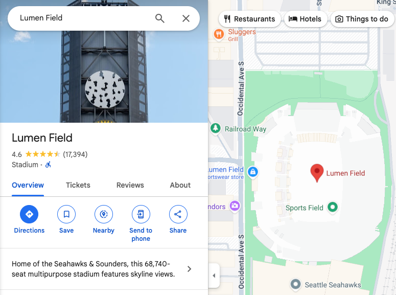
Example 1: Searching for the place name "Lumen Field" results in the following map:
https://www.google.com/maps/search/?api=1&query=lumen+field
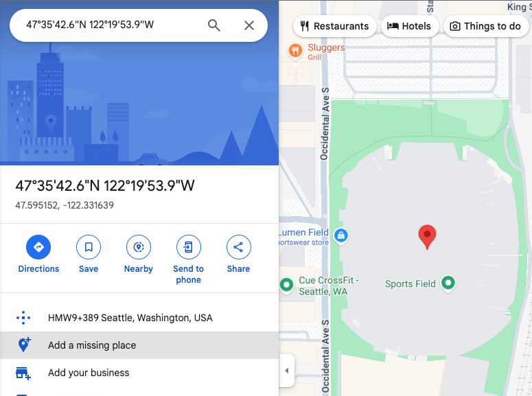
Example 2: Searching for Lumen Field using only latitude/longitude coordinates results in the following map. Notice that there is a pin in the map, but no additional place information is provided on the map or in the side panel:
https://www.google.com/maps/search/?api=1&query=47.5951518%2C-122.3316393
Example 3: Searching for Lumen Field using latitude/longitude coordinates as well as the place ID results in the following map:
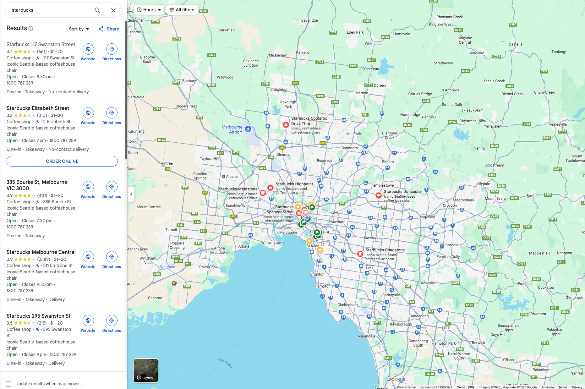
Example 4: Searching for the place name "Starbucks" results in the following map:
https://www.google.com/maps/search/?api=1&query=starbucks
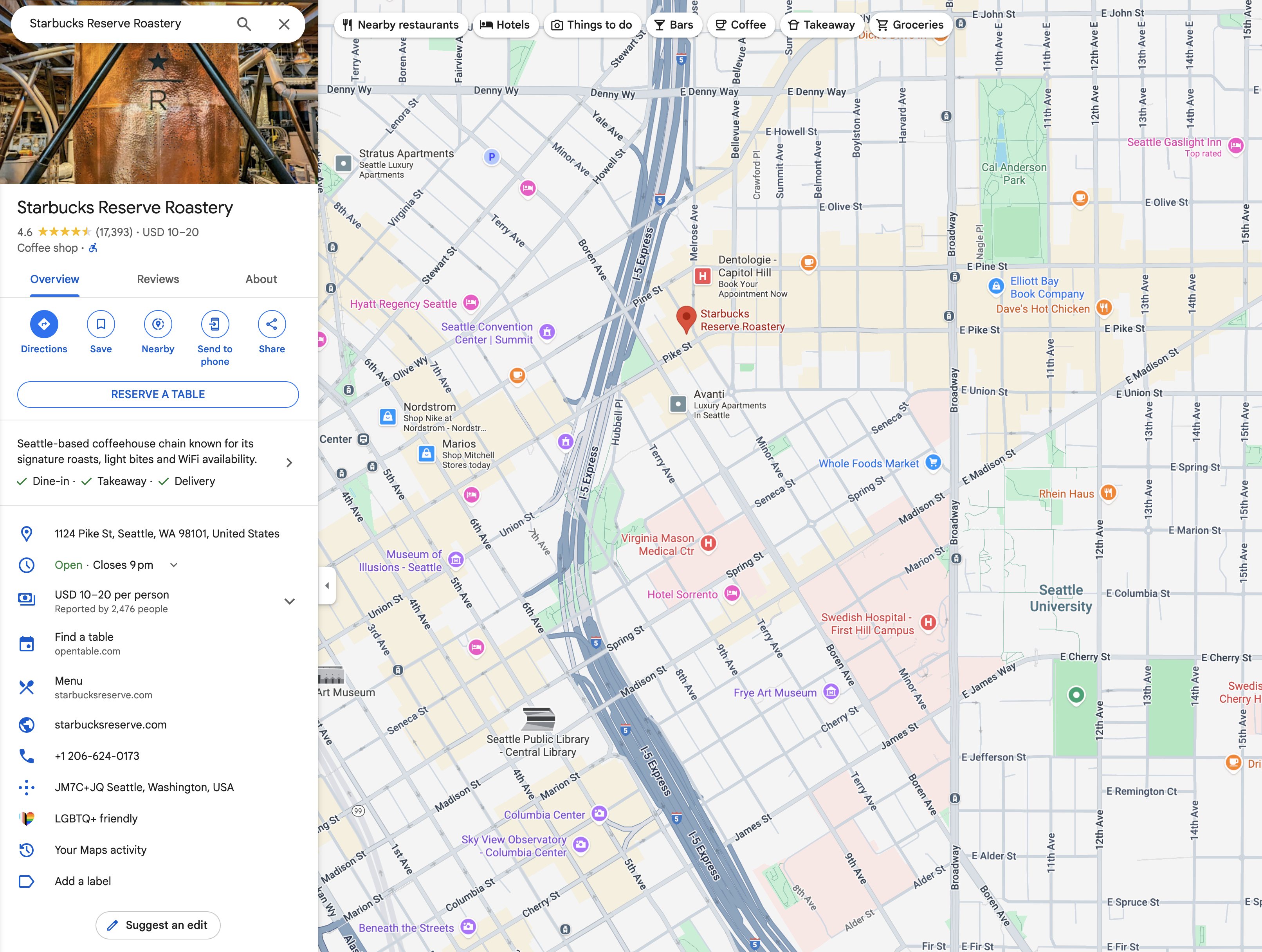
Example 5: Searching for a specific Starbucks using place name and place ID results in the following map:
https://www.google.com/maps/search/?api=1&query=starbucks&query_place_id=ChIJsU30zM1qkFQRbnOm1_LBoG0
When your goal is to display a specific place’s details, construct the Search URLs using one of the following recommended formats:
query=PLACE_NAME,ADDRESSquery=PLACE_NAME&query_place_id=PLACE_ID
To programmatically retrieve Place IDs, you can use the Places API: Text Search(ID Only) features. This is a non-cost method for obtaining Place IDs. Learn more about Place ID, and Place API(New) request.
Place IDs can also be retrieved when a user clicks or taps a POI on maps. Find out more details about clickable POI icons (JavaScript, Android, iOS)
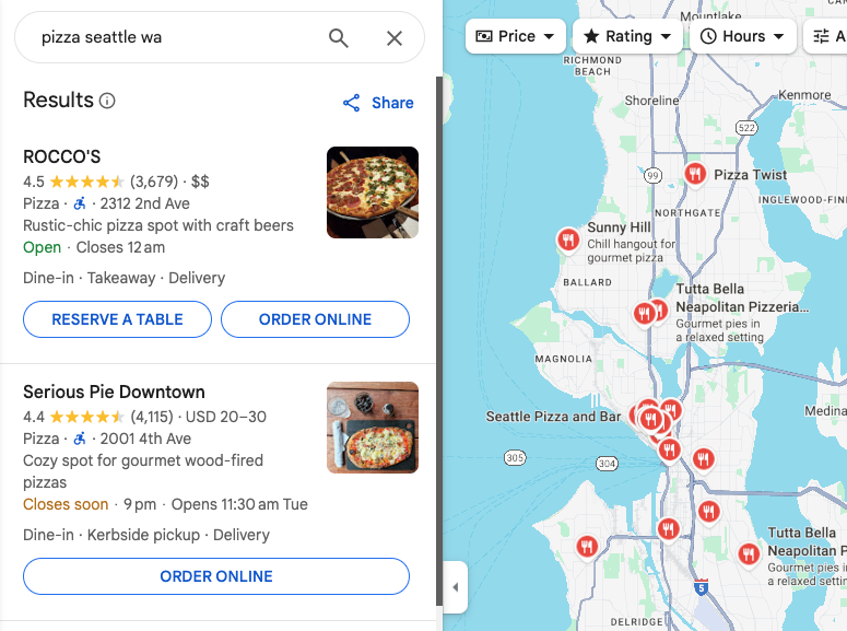
Categorical search
In a categorical search, you pass a general search term, and Google Maps
attempts to find listings that match your criteria near the location you specify.
If no location is specified, Google Maps attempts to find listings nearby
your current location. If you prefer to provide a location for a categorical search,
include the location in the general search string
(for example, pizza+seattle+wa).
In this example, a search for pizza restaurants in Seattle, WA, results in the following map:
https://www.google.com/maps/search/?api=1&query=pizza+seattle+wa
Directions
Directions action displays the path between two or more specified points on the map, as well as the distance and travel time.
Forming the Directions URL
https://www.google.com/maps/dir/?api=1¶meters
Parameters
origin: Defines the starting point from which to display directions. Defaults to most relevant starting location, such as device location, if available. If none, the resulting map may provide a blank form to allow a user to enter the origin. The value can be either a place name, address, or comma-separated latitude/longitude coordinates. A string should be URL-encoded, so an address such as "City Hall, New York, NY" should be converted toCity+Hall%2C+New+York%2C+NY.Note: This parameter is optional, unless you specify an
origin_place_idin your URL. If you choose to specify anorigin_place_id, you must also include anoriginin the URL.origin_place_id(optional): A place ID is a textual identifier that uniquely identifies a place. If you are trying to definitively specify an establishment, using a place ID is the best guarantee that you will link to the right place. URLs that use this parameter must also include anorigin.destination: Defines the endpoint of the directions. If none, the resulting map may provide a blank form to allow the user to enter the destination. The value can be either a place name, address, or comma-separated latitude/longitude coordinates. A string should be URL-encoded, so an address such as "City Hall, New York, NY" should be converted toCity+Hall%2C+New+York%2C+NY.Note: This parameter is optional, unless you specify a
destination_place_idin your URL. If you choose to specify adestination_place_id, you must also include adestinationin the URL.destination_place_id(optional): A place ID is a textual identifier that uniquely identifies a place. If you are trying to definitively specify an establishment, using a place ID is the best guarantee that you will link to the right place. URLs that use this parameter must also include adestination.travelmode(optional): Defines the method of travel. Here's the list of options:drivingwalking: Prefers pedestrian paths and sidewalks, where available.bicycling: Routes through bike paths, where available. "Bicycling" refers to human-powered travel mode.two-wheeler: Routes through preferred streets for two-wheelers, where available. "Two-wheeler" refers to two-wheeled motorized vehicles, such as motorcycles. For more information, see Two-wheeler coverage.transitdir_action=navigate(optional): Launches either turn-by-turn navigation or route preview to the specified destination, based on whether the origin is available. If the user specifies an origin and it is not close to the user's current location, or the current device location is unavailable, the map launches a route preview. If the user does not specify an origin (in which case the origin defaults to the current device location), or the origin is close to the user's current location, the map launches turn-by-turn navigation. Note that navigation is not available on all Google Maps products and/or between all destinations; in those cases this parameter will be ignored.waypoints: Specifies one or more intermediary places to route directions through between theoriginanddestination. Multiple waypoints can be specified by using the pipe character (|) to separate places (for example,Berlin,Germany|Paris,France). The number of waypoints allowed varies by the platform where the link opens, with up to three waypoints supported on mobile browsers, and a maximum of nine waypoints supported otherwise. Waypoints are displayed on the map in the same order they are listed in the URL. Each waypoint can be either a place name, address, or comma-separated latitude/longitude coordinates. Strings should be URL-encoded, so waypoints such as "Berlin,Germany|Paris,France" should be converted toBerlin%2CGermany%7CParis%2CFrance.Notes:
- Waypoints are not supported on all Google Maps products; in those cases this parameter will be ignored.
- This parameter is optional, unless you specify
waypoint_place_idsin your URL. If you choose to specifywaypoint_place_ids, you must also includewaypointsin the URL.
waypoint_place_ids(optional): A place ID is a textual identifier that uniquely identifies a place.Waypoint_place_idsallows you to provide a list of place IDs to match the list ofwaypoints. Place IDs should be listed in the same order as the waypoints, and separated using the pipe character "|" ( URL-encoded as%7C). If you are trying to definitively specify certain establishments, place IDs are the best guarantee that you will link to the right places. URLs that use this parameter must also includewaypoints.avoid(optional): Sets features that route should try to avoid. It can be set to one or more of these options, separated by a comma character "," ( URL-encoded as%2C):ferrieshighwaystolls
travelmode is specified, the Google Map shows
one or more of the most relevant modes for the specified route and/or user preferences.
Directions examples
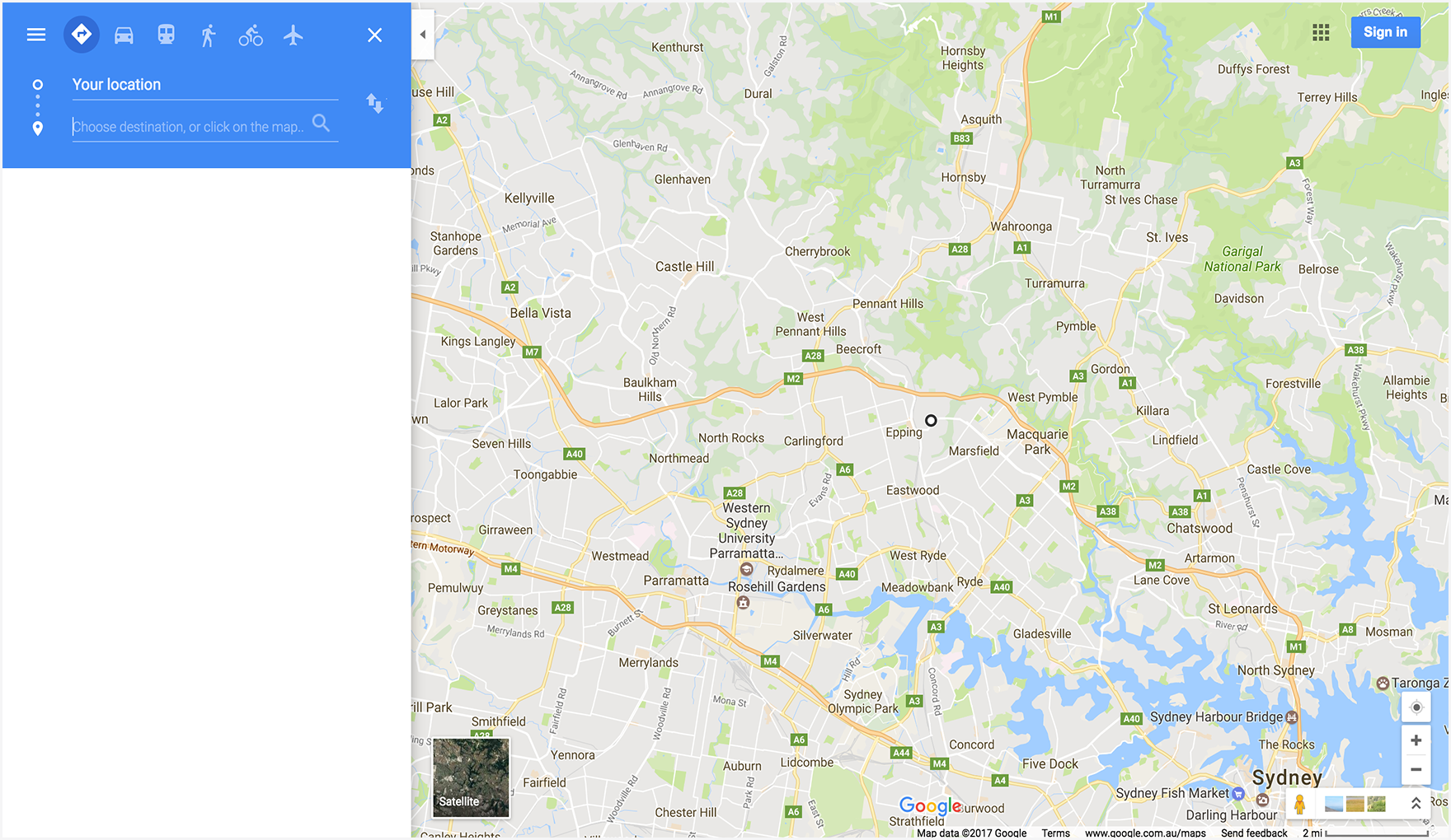
The following URL launches a map in directions mode and provides a form to allow the user to enter the origin and destination.
https://www.google.com/maps/dir/?api=1
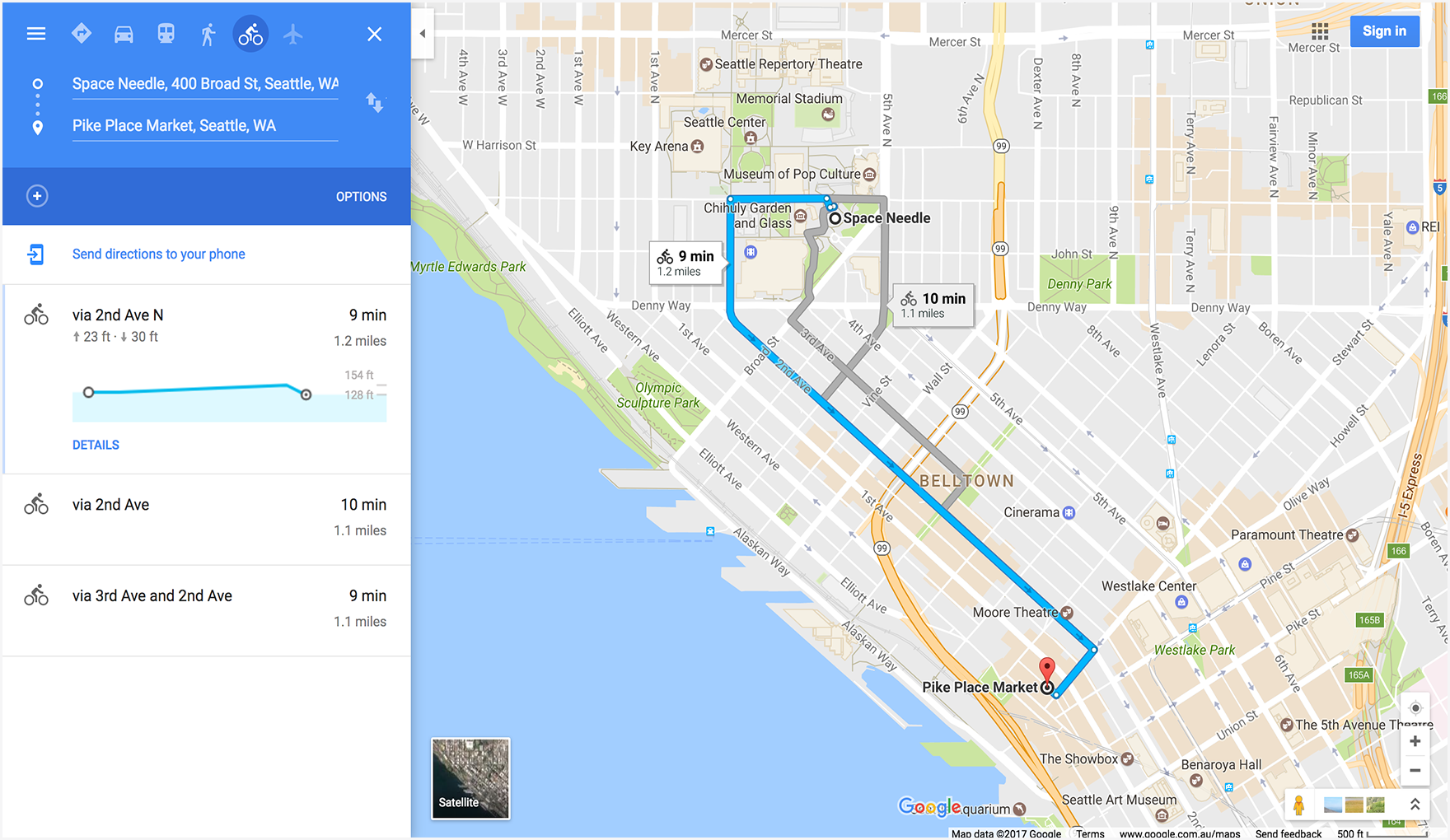
The following example launches a map with bicycling directions from the Space Needle to Pike Place Market, in Seattle, WA.
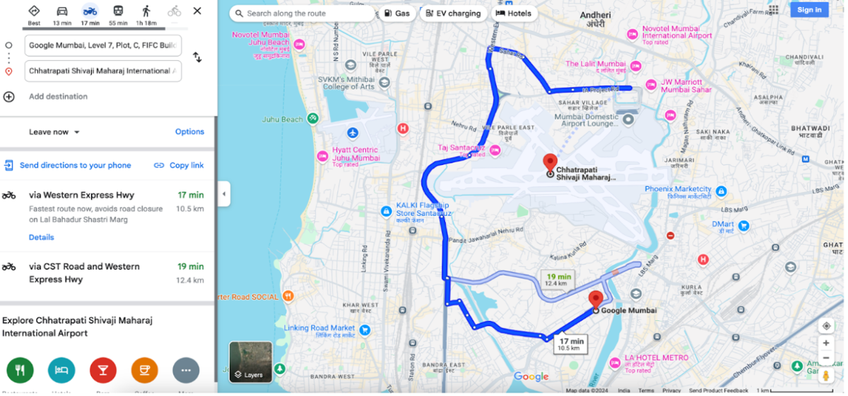
The following example launches a map with two-wheeler directions from Google Mumbai to the Mumbai International Airport.
.
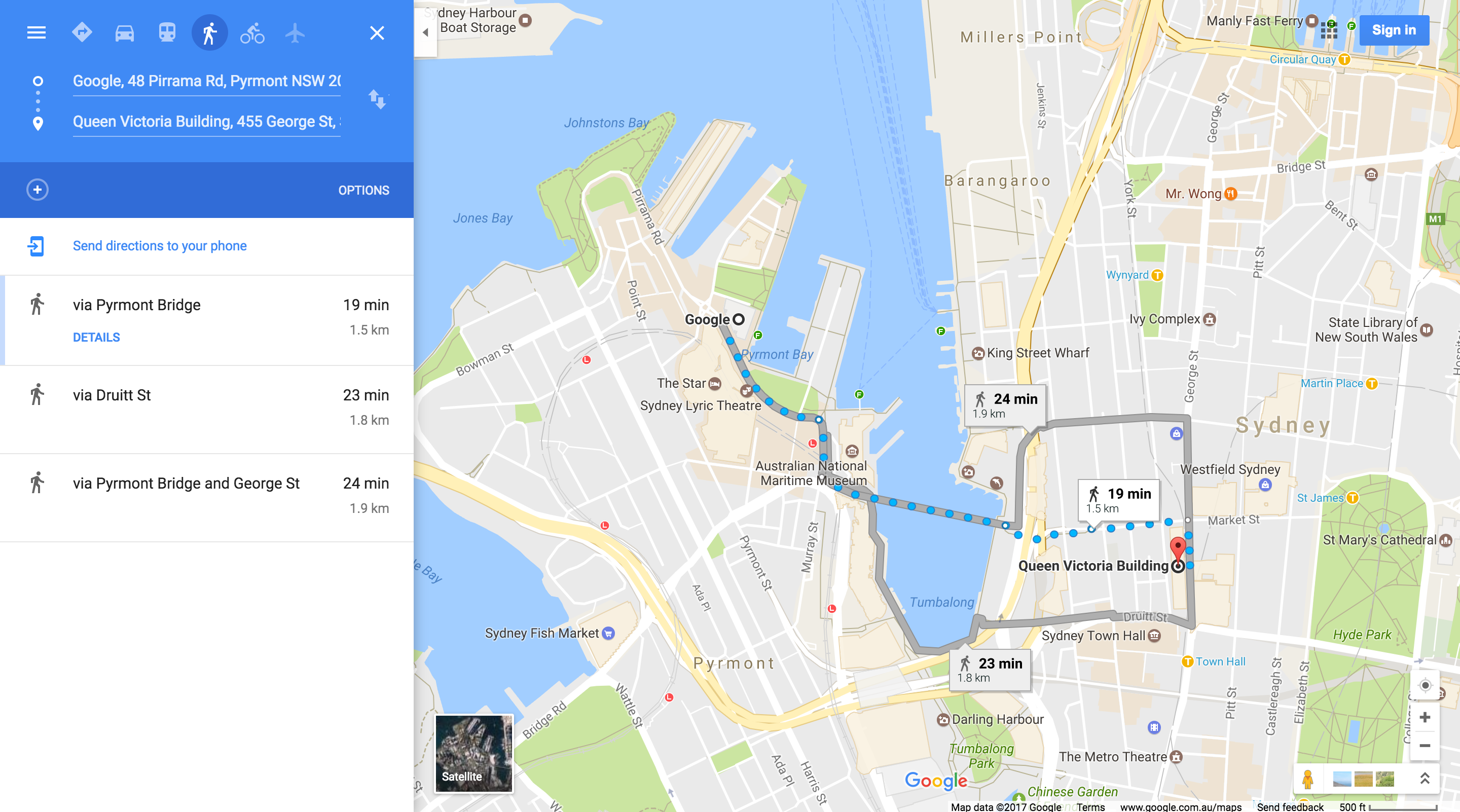
The following example launches a map with walking directions from Google Sydney, Australia to the Queen Victoria Building.
Displaying a map
The map action returns a map with no markers or directions.
Forming the map URL
https://www.google.com/maps/@?api=1&map_action=map¶meters
Parameters
map_action=map(required): Specifies the type of map view to display. Maps and Street View share the same endpoint. To ensure a map is displayed, themap_actionmust be specified asmap.center(optional): Defines the center of the map window, and accepts latitude/longitude coordinates as comma-separated values (for example,-33.8569,151.2152).zoom(optional): Sets the initial zoom level of the map. Accepted values are whole integers ranging from 0 (the whole world) to 21 (individual buildings). The upper limit can vary depending on the map data available at the selected location. The default is 15.basemap(optional): Defines the type of map to display. The value can be eitherroadmap(default),satellite, orterrain.layer(optional): Defines an extra layer to display on the map, if any. The value can be one of the following:none(default),transit,traffic, orbicycling.
Map examples
This example URL launches a default Google Map, centered on the user’s current location.
https://www.google.com/maps/@?api=1&map_action=map
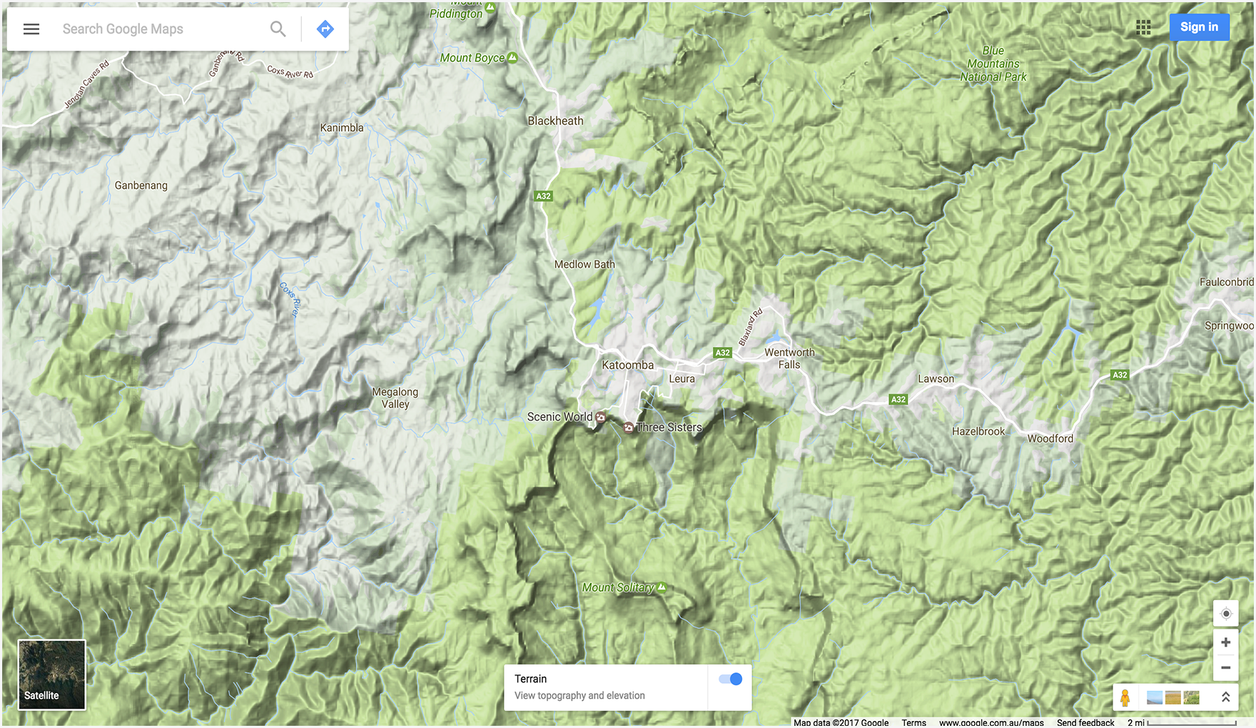
The following example displays a map centered on Katoomba, NSW,
Australia (at -33.712206,150.311941), and sets the optional zoom
and basemap parameters.
Displaying a Street View panorama
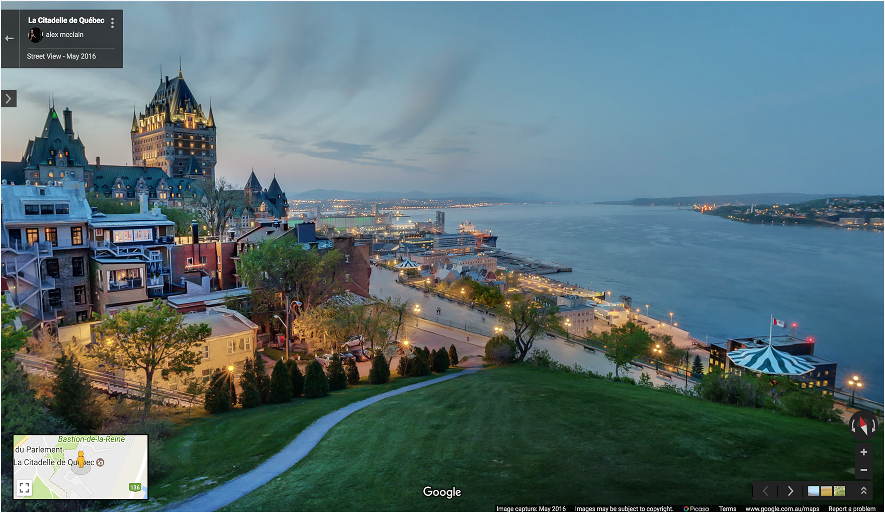
The pano action lets you launch a viewer to display Street View images as interactive panoramas. Each Street View panorama provides a full 360-degree view from a single location. Images contain 360 degrees of horizontal view (a full wrap-around) and 180 degrees of vertical view (from straight up to straight down). The pano action launches a viewer that renders the resulting panorama as a sphere with a camera at its center. You can manipulate the camera to control the zoom and the orientation of the camera.
Google Street View provides panoramic views from designated locations throughout its coverage area. User contributed Photospheres and Street View special collections are also available.
Forming the Street View URL
https://www.google.com/maps/@?api=1&map_action=pano¶meters
Parameters
map_action=pano(required): Specifies the type of view to display. Maps and Street View share the same endpoint. To ensure a panorama is displayed, theactionmust be specified aspano.
One of the following URL parameters is also required:
viewpoint: The viewer displays the panorama photographed closest to theviewpointlocation, specified as comma-separated latitude/longitude coordinates (for example 46.414382,10.013988). Because Street View imagery is periodically refreshed, and photographs may be taken from slightly different positions each time, it's possible that your location may snap to a different panorama when imagery is updated.pano: The specific panorama ID of the image to display. If you specify apanoyou may also specify aviewpoint. Theviewpointis only used if Google Maps cannot find the panorama ID. Ifpanois specified but not found, and aviewpointis NOT specified, no panorama image is displayed. Instead, Google Maps opens in default mode, displaying a map centered on the user's current location.
The following URL parameters are optional:
heading: Indicates the compass heading of the camera in degrees clockwise from North. Accepted values are from -180 to 360 degrees. If omitted, a default heading is chosen based on the viewpoint (if specified) of the query and the actual location of the image.pitch: Specifies the angle, up or down, of the camera. The pitch is specified in degrees from -90 to 90. Positive values will angle the camera up, while negative values will angle the camera down. The default pitch of 0 is set based on on the position of the camera when the image was captured. Because of this, a pitch of 0 is often, but not always, horizontal. For example, an image taken on a hill will likely exhibit a default pitch that is not horizontal.fov: Determines the horizontal field of view of the image. The field of view is expressed in degrees, with a range of 10 - 100. It defaults to 90. When dealing with a fixed-size viewport, the field of view is considered the zoom level, with smaller numbers indicating a higher level of zoom.
Street View examples
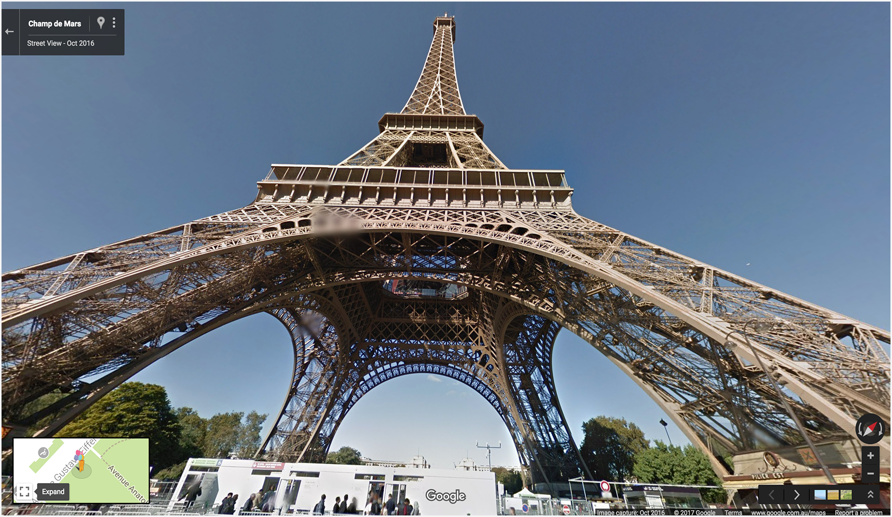
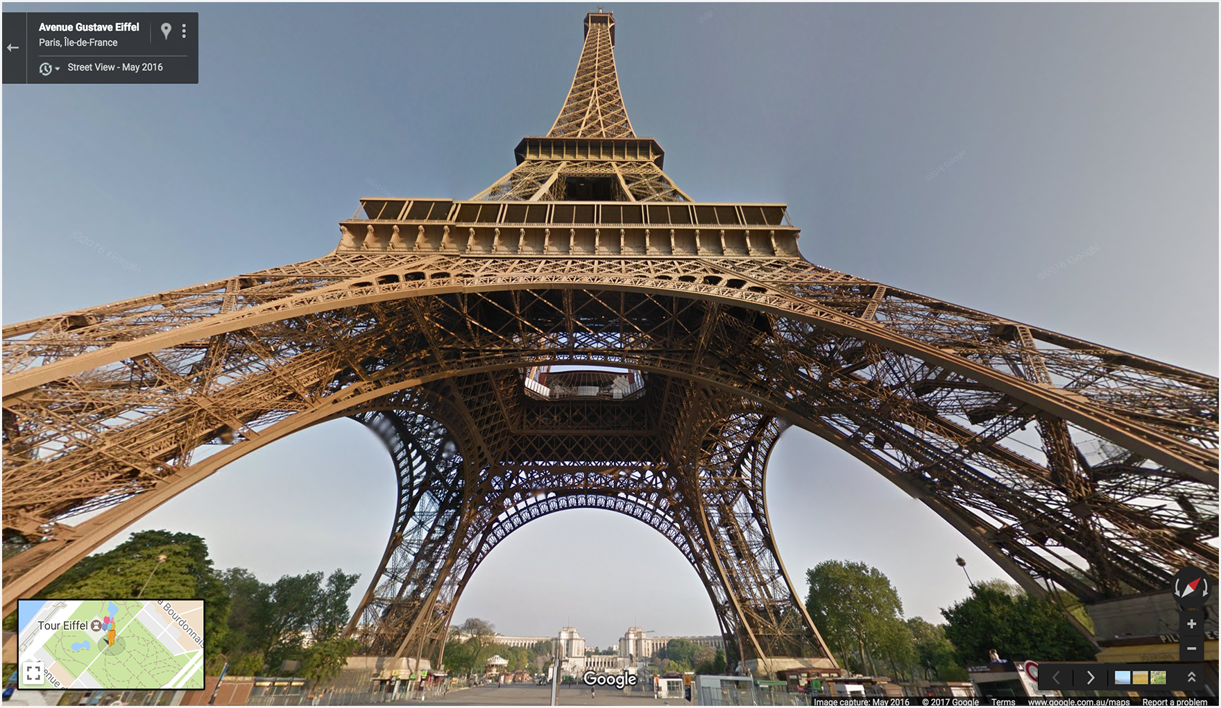
The first two examples display a panorama of the Eiffel Tower. Example one
uses only a viewpoint for the location, and sets the optional
heading, pitch, and fov parameters. For comparison,
example two uses a pano ID as well as the same parameters set in the
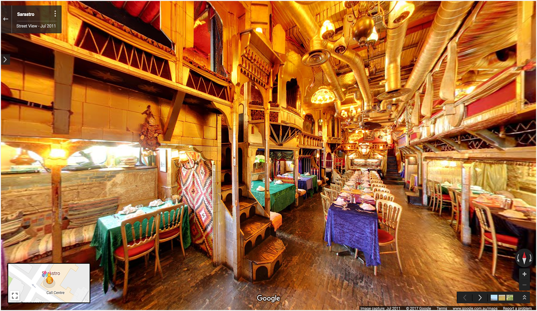
first example. The third example displays an indoor panorama image.
Example 1: Uses only a viewpoint to specify location.
Example 2: Uses a pano ID as well as a viewpoint location.
The pano ID takes precedence over the viewpoint.
In this example, the panorama ID is found, so the viewpoint is ignored. Notice
that the panorama image that is displayed for the pano ID is slightly different,
and more recent, than the image found using only the viewpoint.
Example 3: Displays a panorama of the interior of the Sarastro restaurant in London, UK, specified with a panorama ID.
https://www.google.com/maps/@?api=1&map_action=pano&pano=4U-oRQCNsC6u7r8gp02sLA
Finding a panorama ID
To find the ID of a specific panorama image, there are multiple methods you can use.
- For JavaScript, use the StreetViewPanorama class.
- For Android, use the public class StreetViewPanoramaLocation.
- For iOS, use the GMSPanorama class.
- You may also make metadata requests using the Google Street View Image API. Image metadata requests provide data about Street View panoramas, including the panorama ID.
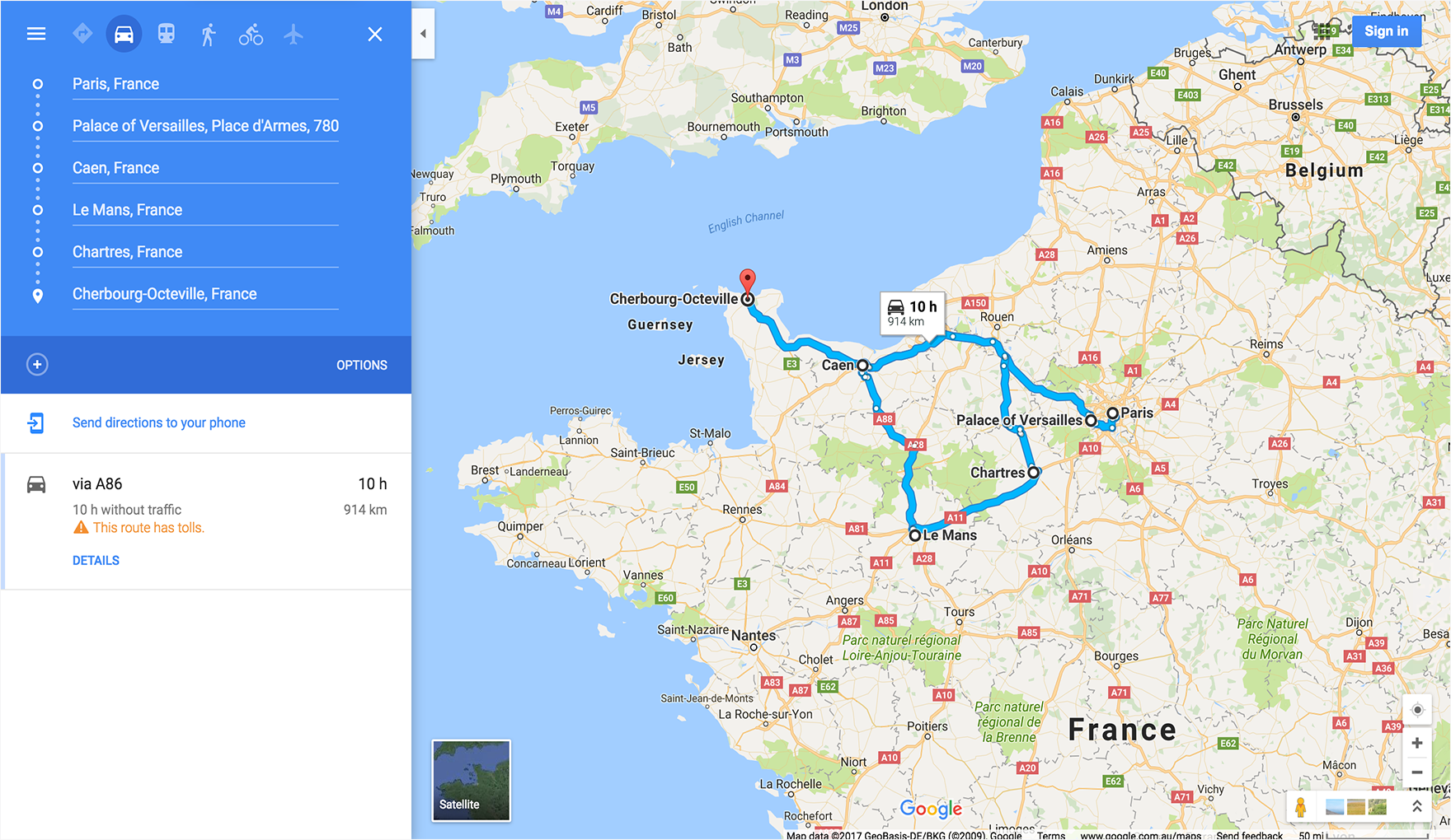
More examples
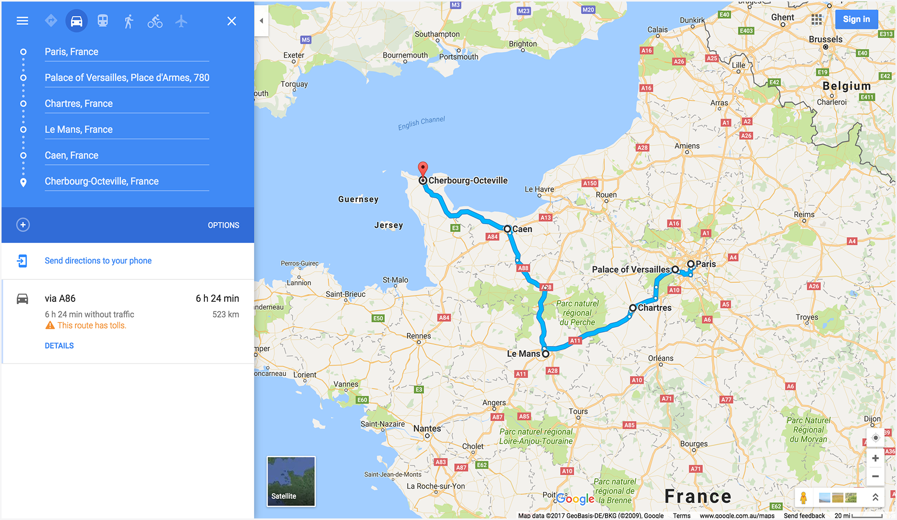
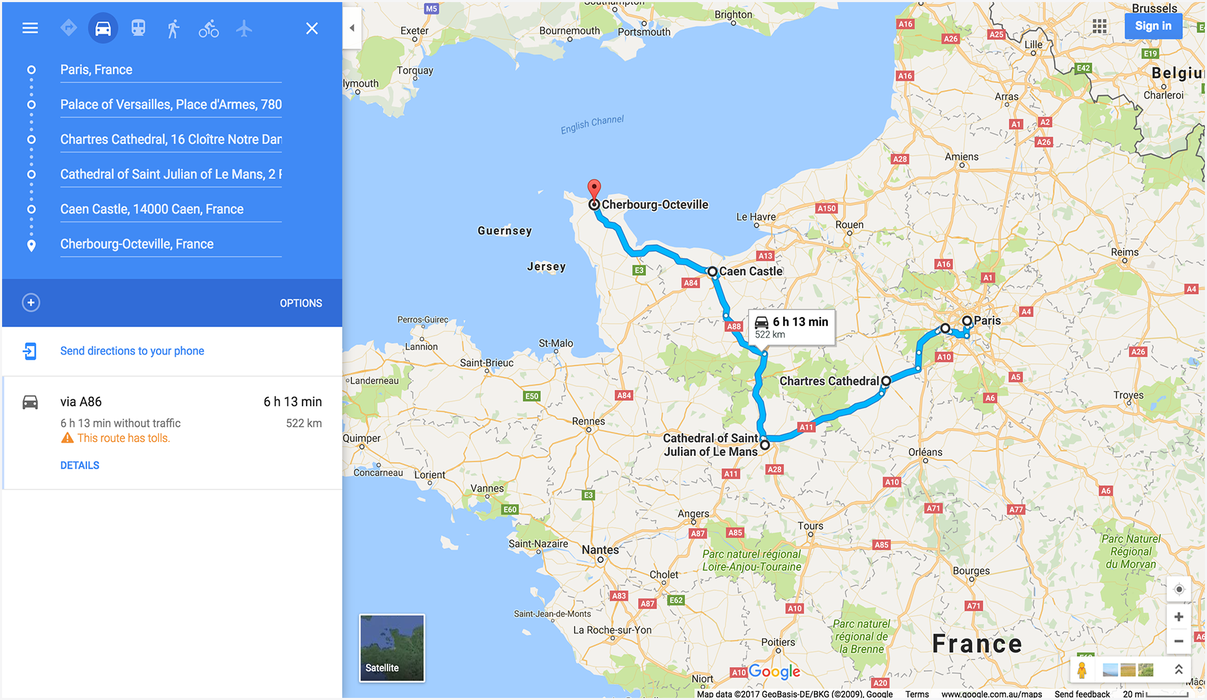
Directions examples using waypoints
The following directions examples launch Google Maps and display driving directions from Paris, France to Cherbourg, France, routing through the following waypoints:
| City, Country | Place Name | Place ID |
|---|---|---|
| 1. Versailles, France | The Palace of Versailles | ChIJdUyx15R95kcRj85ZX8H8OAU |
| 2. Chartres, France | Chartres Cathedral | ChIJKzGHdEgM5EcR_OBTT3nQoEA |
| 3. Le Mans, France | Cathedral of Saint Julian of Le Mans | ChIJG2LvQNCI4kcRKXNoAsPi1Mc |
| 4. Caen, France | Caen Castle | ChIJ06tnGbxCCkgRsfNjEQMwUsc |
In the example URLs, the waypoints are defined in different ways so you can compare the differences in the display of the waypoints on the resulting maps.
Example 1: Waypoints defined as City, Country:
Example 2: Waypoints defined as specific place names:
Example 3: Waypoints defined as City, Country, and also provides
waypoint_place_ids for a specific establishment in each waypoint:

Example 4: Defines waypoints as City, Country, but lists the waypoints in a different order compared to the previous examples. Demonstrates that the map displays waypoints in the order they are listed in the URL.
Map examples
Displays a map with a specified basemap (satellite) and
layer (transit).
![]()
Street View examples
Displays a Street View panorama using a FIFE image key as the pano ID. Note
that the pano ID is prefaced with F:.
Improving Maps URLs with UTM parameters
To help Google better understand how developers are integrating Maps URLs and to ensure optimal performance,
we encourage you to include UTM tracking parameters in your URL construction. By adding utm_source and utm_campaign parameters,
you provide valuable data that allows us to analyze usage patterns and improve the Maps URLs product.
For the utm_source parameter, please use the name of your application. The utm_campaign parameter should reflect
the user's intended action, such as "location_sharing," "place_details_search," or "directions_request."
For example, a URL with UTM parameters might look like this:
https://www.google.com/maps/search/?api=1&query=Sydney+Opera+House&query_place_id=ChIJ3S-JXmauEmsRUcIaWtf4MzE&utm_source=YOUR_APP_NAME&utm_campaign=place_details_search