The Google Maps app for Android exposes several intents that you can use to launch Google Maps in display, search, navigation, or Street View modes. If you want to embed a map in your app, please refer to the Google Maps Android API Getting Started Guide.
Overview
Intents let you start an activity in another app by describing a simple action
you'd like to perform (such as "display a map" or "show directions to the
airport") in an
Intent
object. The
Google Maps app for Android
supports several different intents, allowing you to launch the Google Maps app
and perform one of four actions:
- Display a map at a specified location and zoom level.
- Search for locations or places, and display them on a map.
- Request directions from one location to another. Directions can be returned for three modes of transportation: driving, walking, bicycling.
- Display panorama imagery in Google Street View.
This page describes the intents that you can use with Google Maps app for Android. For more information on Intents and Intent Filters, or Intents common to the Android platform, refer to the Android developer documentation.
Intent requests
In order to launch Google Maps with an intent you must first create an
Intent
object, specifying its action, URI and package.
- Action: All Google Maps intents are called as a View action —
ACTION_VIEW. - URI: Google Maps intents use URL encoded that specify a desired action, along with some data with which to perform the action.
- Package: Calling
setPackage("com.google.android.apps.maps")will ensure that the Google Maps app for Android handles the Intent. If the package isn't set, the system will determine which apps can handle theIntent. If multiple apps are available, the user may be asked which app they would like to use.
After creating the Intent, you can request that the system launch the related
app in a number of ways. A common method is to pass the Intent to the
startActivity()
method. The system will launch the necessary app — in this case Google
Maps — and start the
corresponding Activity.
Java
// Create a Uri from an intent string. Use the result to create an Intent.
Uri gmmIntentUri = Uri.parse("google.streetview:cbll=46.414382,10.013988");

// Create an Intent from gmmIntentUri. Set the action to ACTION_VIEW
Intent mapIntent = new Intent(Intent.ACTION_VIEW, gmmIntentUri);
// Make the Intent explicit by setting the Google Maps package
mapIntent.setPackage("com.google.android.apps.maps");

// Attempt to start an activity that can handle the Intent
startActivity(mapIntent);
Kotlin
// Create a Uri from an intent string. Use the result to create an Intent.
val gmmIntentUri = Uri.parse("google.streetview:cbll=46.414382,10.013988")

// Create an Intent from gmmIntentUri. Set the action to ACTION_VIEW
val mapIntent = Intent(Intent.ACTION_VIEW, gmmIntentUri)
// Make the Intent explicit by setting the Google Maps package
mapIntent.setPackage("com.google.android.apps.maps")

// Attempt to start an activity that can handle the Intent
startActivity(mapIntent)
If the system cannot identify an app that can respond to the intent, your app may crash. For this reason, you should first verify that a receiving application is installed before you present one of these intents to a user.
To verify that an app is available to receive the intent, call
resolveActivity() on your
Intent
object. If the result is non-null, there is at least one app that can handle the
intent and it's safe to call
startActivity().
If the result is null, you should not use the intent and, if possible, you
should disable the feature that invokes the intent.
Java
if (mapIntent.resolveActivity(getPackageManager()) != null) {
  ...
}
Kotlin
mapIntent.resolveActivity(packageManager)?.let {
  ...
}
For example, to display a map of San Francisco, you can use the following code:
Java
Uri gmmIntentUri = Uri.parse("geo:37.7749,-122.4194");
Intent mapIntent = new Intent(Intent.ACTION_VIEW, gmmIntentUri);
mapIntent.setPackage("com.google.android.apps.maps");
if (mapIntent.resolveActivity(getPackageManager()) != null) {
  startActivity(mapIntent);
}
Kotlin
val gmmIntentUri = Uri.parse("geo:37.7749,-122.4194")
val mapIntent = Intent(Intent.ACTION_VIEW, gmmIntentUri)
mapIntent.setPackage("com.google.android.apps.maps")
mapIntent.resolveActivity(packageManager)?.let {
  startActivity(mapIntent)
}
URL encoded query strings
All strings passed to the Google Maps Intents must be URI encoded. For example,
the string "1st & Pike, Seattle" should become 1st%20%26%20Pike%2C%20Seattle.
Spaces in the string can be encoded with %20 or replaced with the plus sign (+).
You can use the android.net.Uri parse() method to encode your strings.
For example:
Java
Uri gmmIntentUri =
  Uri.parse("geo:37.7749,-122.4192?q=" + Uri.encode("1st & Pike, Seattle"));
Kotlin
val gmmIntentUri =
  Uri.parse("geo:37.7749,-122.4192?q=" + Uri.encode("1st & Pike, Seattle"))
Displaying a map
Use the geo: intent to display a map at a specified location and zoom level.
geo:latitude,longitude?z=zoom
Parameters
latitudeandlongitudeset the center point of the map.zoptionally sets the initial zoom level of the map. Accepted values range from 0 (the whole world) to 21 (individual buildings). The upper limit can vary depending on the map data available at the selected location.
Examples
Java
// Creates an Intent that will load a map of San Francisco
Uri gmmIntentUri = Uri.parse("geo:37.7749,-122.4194");
Intent mapIntent = new Intent(Intent.ACTION_VIEW, gmmIntentUri);
mapIntent.setPackage("com.google.android.apps.maps");
startActivity(mapIntent);
Kotlin
// Creates an Intent that will load a map of San Francisco
val gmmIntentUri = Uri.parse("geo:37.7749,-122.4194")
val mapIntent = Intent(Intent.ACTION_VIEW, gmmIntentUri)
mapIntent.setPackage("com.google.android.apps.maps")
startActivity(mapIntent)
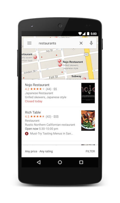
Searching for a location
Use this intent to display search queries within a specified viewport. When the query has a single result, you can use this intent to display a pin at a particular place or address, such as a landmark, business, geographic feature, or town.
geo:latitude,longitude?q=query
geo:0,0?q=my+street+address
geo:0,0?q=latitude,longitude(label)
Parameters
In addition to the parameters used to display a map, Search supports the following parameters:
qdefines the place(s) to highlight on the map. Theqparameter is required for all Search requests. It accepts a location as either a place name or address. The string should be URL-encoded, so an address such as "City Hall, New York, NY" should be converted to City+Hall,New+York,NY.labellets you set a custom label at a place identified on the map. Thelabelmust be specified as a String.
Categorical search
If you pass a general search term, Google Maps will attempt to find a location near the lat/lng you specified that matches your criteria. If no location is specified, Google Maps will try to find nearby listings. For example:
Java
// Search for restaurants nearby
Uri gmmIntentUri = Uri.parse("geo:0,0?q=restaurants");
Intent mapIntent = new Intent(Intent.ACTION_VIEW, gmmIntentUri);
mapIntent.setPackage("com.google.android.apps.maps");
startActivity(mapIntent);

// Search for restaurants in San Francisco
Uri gmmIntentUri = Uri.parse("geo:37.7749,-122.4194?q=restaurants");
Intent mapIntent = new Intent(Intent.ACTION_VIEW, gmmIntentUri);
mapIntent.setPackage("com.google.android.apps.maps");
startActivity(mapIntent);
Kotlin
// Search for restaurants nearby
val gmmIntentUri = Uri.parse("geo:0,0?q=restaurants")
val mapIntent = Intent(Intent.ACTION_VIEW, gmmIntentUri)
mapIntent.setPackage("com.google.android.apps.maps")
startActivity(mapIntent)

// Search for restaurants in San Francisco
val gmmIntentUri =
  Uri.parse("geo:37.7749,-122.4194?q=restaurants")
val mapIntent = Intent(Intent.ACTION_VIEW, gmmIntentUri)
mapIntent.setPackage("com.google.android.apps.maps")
startActivity(mapIntent)
You can further bias the search results by specifying a zoom parameter along with the query string. In the below example, adding a zoom of 10 will attempt to find restaurants at a city level instead of nearby.
Java
Uri gmmIntentUri = Uri.parse("geo:37.7749,-122.4194?z=10&q=restaurants");
Intent mapIntent = new Intent(Intent.ACTION_VIEW, gmmIntentUri);
mapIntent.setPackage("com.google.android.apps.maps");
startActivity(mapIntent);
Kotlin
val gmmIntentUri =
  Uri.parse("geo:37.7749,-122.4194?z=10&q=restaurants")
val mapIntent = Intent(Intent.ACTION_VIEW, gmmIntentUri)
mapIntent.setPackage("com.google.android.apps.maps")
startActivity(mapIntent)
Location search
Searching for a specific address will display a pin at that location.
Java
Uri gmmIntentUri = Uri.parse("geo:0,0?q=1600 Amphitheatre Parkway, Mountain+View, California");
Intent mapIntent = new Intent(Intent.ACTION_VIEW, gmmIntentUri);
mapIntent.setPackage("com.google.android.apps.maps");
startActivity(mapIntent);
Kotlin
val gmmIntentUri =
  Uri.parse("geo:0,0?q=1600 Amphitheatre Parkway, Mountain+View, California")
val mapIntent = Intent(Intent.ACTION_VIEW, gmmIntentUri)
mapIntent.setPackage("com.google.android.apps.maps")
startActivity(mapIntent)
The above example sets a lat/lng of 0,0, but passes an address as a query
string. When searching for a very specific location, the latitude and longitude
are not required. However, if you do not know the exact address, you can
attempt to bias the results of the search by specifying a coordinate. For
example, performing an address search for 'Main Street' will return too many
results.
Java
// Searching for 'Main Street' will return too many results
Uri gmmIntentUri = Uri.parse("geo:0,0?q=101+main+street");
Kotlin
// Searching for 'Main Street' will return too many results
val gmmIntentUri = Uri.parse("geo:0,0?q=101+main+street")
Adding a lat/lng to the intent URI will bias the results towards a particular area:
Java
// Searches for 'Main Street' near San Francisco
Uri gmmIntentUri = Uri.parse("geo:37.7749,-122.4194?q=101+main+street");
Intent mapIntent = new Intent(Intent.ACTION_VIEW, gmmIntentUri);
mapIntent.setPackage("com.google.android.apps.maps");
startActivity(mapIntent);
Kotlin
// Searches for 'Main Street' near San Francisco
val gmmIntentUri =
  Uri.parse("geo:37.7749,-122.4194?q=101+main+street")
val mapIntent = Intent(Intent.ACTION_VIEW, gmmIntentUri)
mapIntent.setPackage("com.google.android.apps.maps")
startActivity(mapIntent)
When you know your search will return a single value, you may wish to pass an
optional label. Labels must be specified as a String, and will appear under the
map marker. Note that labels are only available when q is specified as a
lat/lng coordinate.
Java
// Display a label at the location of Google's Sydney office
Uri gmmIntentUri = Uri.parse("geo:0,0?q=Google+Sydney@-33.8666,151.1957");
Intent mapIntent = new Intent(Intent.ACTION_VIEW, gmmIntentUri);
mapIntent.setPackage("com.google.android.apps.maps");
startActivity(mapIntent);
Kotlin
// Display a label at the location of Google's Sydney office
val gmmIntentUri =
  Uri.parse("geo:0,0?q=-33.8666,151.1957(Google+Sydney)")
val mapIntent = Intent(Intent.ACTION_VIEW, gmmIntentUri)
mapIntent.setPackage("com.google.android.apps.maps")
startActivity(mapIntent)
As an alternative to a street address or a latitude/longitude, you can display a pin at a known location using a plus code.
Java
// Display the location of Google, San Francisco using a global plus code.
Uri gmmIntentUri = Uri.parse("http://plus.codes/849VQJQ5+XX");
// Equivalently, define the same location using a local plus code
gmmIntentUri = Uri.parse("https://plus.codes/QJQ5+XX,San%20Francisco");
// Construct and use the Intent as in the examples above
Kotlin
// Display the location of Google, San Francisco using a global plus code.
var gmmIntentUri = Uri.parse("http://plus.codes/849VQJQ5+XX")
// Equivalently, define the same location using a local plus code
gmmIntentUri = Uri.parse("https://plus.codes/QJQ5+XX,San%20Francisco")
// Construct and use the Intent as in the examples above
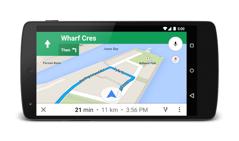
Launching turn-by-turn navigation
Use this intent to launch Google Maps navigation with turn-by-turn directions to the address or coordinate specified. Directions are always given from the user's current location.
google.navigation:q=a+street+address
google.navigation:q=latitude,longitude
Parameters
q: Sets the end point for navigation searches. This value can be latitude, longitude coordinates or a query formatted address. If it is a query string that returns more than one result, the first result will be selected.modesets the method of transportation. Mode is optional, and can be set to one of:dfor driving (default)bfor bicyclinglfor two-wheelerwfor walking
avoidsets features the route should try to avoid. Avoid is optional and can be set to one or more of:tfor tollshfor highwaysffor ferries
Examples
The below Intent will request turn-by-turn navigation to Taronga Zoo, in
Sydney Australia:
Java
Uri gmmIntentUri = Uri.parse("google.navigation:q=Taronga+Zoo,+Sydney+Australia");
Intent mapIntent = new Intent(Intent.ACTION_VIEW, gmmIntentUri);
mapIntent.setPackage("com.google.android.apps.maps");
startActivity(mapIntent);
Kotlin
val gmmIntentUri =
  Uri.parse("google.navigation:q=Taronga+Zoo,+Sydney+Australia")
val mapIntent = Intent(Intent.ACTION_VIEW, gmmIntentUri)
mapIntent.setPackage("com.google.android.apps.maps")
startActivity(mapIntent)
If you prefer not to pay tolls or ride a ferry, you can request routing that tries to avoid those things.
Java
Uri gmmIntentUri = Uri.parse("google.navigation:q=Taronga+Zoo,+Sydney+Australia&avoid=tf");
Intent mapIntent = new Intent(Intent.ACTION_VIEW, gmmIntentUri);
mapIntent.setPackage("com.google.android.apps.maps");
startActivity(mapIntent);
Kotlin
val gmmIntentUri =
  Uri.parse("google.navigation:q=Taronga+Zoo,+Sydney+Australia&avoid=tf")
val mapIntent = Intent(Intent.ACTION_VIEW, gmmIntentUri)
mapIntent.setPackage("com.google.android.apps.maps")
startActivity(mapIntent)
If you'd prefer a bit of exercise, you can request bicycling directions instead.
Java
Uri gmmIntentUri = Uri.parse("google.navigation:q=Taronga+Zoo,+Sydney+Australia&mode=b");
Intent mapIntent = new Intent(Intent.ACTION_VIEW, gmmIntentUri);
mapIntent.setPackage("com.google.android.apps.maps");
startActivity(mapIntent);
Kotlin
val gmmIntentUri =
  Uri.parse("google.navigation:q=Taronga+Zoo,+Sydney+Australia&mode=b")
val mapIntent = Intent(Intent.ACTION_VIEW, gmmIntentUri)
mapIntent.setPackage("com.google.android.apps.maps")
startActivity(mapIntent)
If you'd prefer taking a motorized two-wheeler, you can request that the directions
include narrow roads and trails unavailable to cars. The below intent returns
a route in India.
Java
Uri gmmIntentUri = Uri.parse("google.navigation:q=Connaught+Place,+New+Delhi,Delhi&mode=l");
Intent mapIntent = new Intent(Intent.ACTION_VIEW, gmmIntentUri);
mapIntent.setPackage("com.google.android.apps.maps");
startActivity(mapIntent);
Kotlin
val gmmIntentUri =
  Uri.parse("google.navigation:q=Connaught+Place,+New+Delhi,Delhi&mode=l")
val mapIntent = Intent(Intent.ACTION_VIEW, gmmIntentUri)
mapIntent.setPackage("com.google.android.apps.maps")
startActivity(mapIntent)
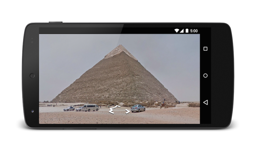
Displaying a Street View panorama
Use the google.streetview intent to launch Google Street View. Google Street View
provides panoramic views from designated locations throughout its
coverage area.
User contributed Photospheres,
and
Street View special collections
are also available.
google.streetview:cbll=latitude,longitude&cbp=0,bearing,0,zoom,tilt
google.streetview:panoid=id&cbp=0,bearing,0,zoom,tilt
Parameters
All google.streetview URIs must include either a cbll or a panoid
parameter.
cbllaccepts a latitude and a longitude as comma-separated values (46.414382,10.013988). The app will display the panorama photographed closest to this location. Because Street View imagery is periodically refreshed, and photographs may be taken from slightly different positions each time, it's possible that your location may snap to a different panorama when imagery is updated.panoidis a specific panorama ID. Google Maps will use the panorama ID if both apanoidand acbllare specified. Panorama IDs are available to an Android app from theStreetViewPanoramaLocationobject.cbpis an optional parameter that adjusts the initial orientation of the camera. Thecbpparameter takes 5 comma-separated values, all of which are optional. The most significant values are the second, fourth and fifth which set the bearing, zoom and tilt respectively. The first and third values are not supported, and should be set to0.bearing: indicates the compass heading of the camera in degrees clockwise from North. True north is 0, east is 90, south is 180, west is 270. Values passed to bearing will wrap; that is, 0°, 360° and 720° all point in the same direction. Bearing is defined as the second of five comma-separated values.zoom: Sets the zoom level of the camera. The default zoom level is set at 0. A zoom of 1 would double the magnification. The zoom is clamped between 0 and the maximum zoom level for the current panorama. This means that any value falling outside this range will be set to the closest extreme that falls within the range. For example, a value of -1 will be set to 0. Zoom is the fourth of five comma-separated values.tilt: specifies the angle, up or down, of the camera. The range is -90 through 0 to 90, with 90 looking straight down, 0 centered on the horizon, and -90 looking straight up.
Examples
Below are some examples of using the Street View intent.
Java
// Displays an image of the Swiss Alps
Uri gmmIntentUri = Uri.parse("google.streetview:cbll=46.414382,10.013988");
Intent mapIntent = new Intent(Intent.ACTION_VIEW, gmmIntentUri);
mapIntent.setPackage("com.google.android.apps.maps");
startActivity(mapIntent);

// Uses a PanoID to show an image from Maroubra beach in Sydney, Australia
Uri gmmIntentUri = Uri.parse("google.streetview:panoid=Iaa2JyfIggYAAAQfCZU9KQ");
Intent mapIntent = new Intent(Intent.ACTION_VIEW, gmmIntentUri);
mapIntent.setPackage("com.google.android.apps.maps");
startActivity(mapIntent);

// Opens Street View between two Pyramids in Giza. The values passed to the
// cbp parameter will angle the camera slightly up, and towards the east.
Uri gmmIntentUri = Uri.parse("google.streetview:cbll=29.9774614,31.1329645&cbp=0,30,0,0,-15");
Intent mapIntent = new Intent(Intent.ACTION_VIEW, gmmIntentUri);
mapIntent.setPackage("com.google.android.apps.maps");
startActivity(mapIntent);
Kotlin
// Displays an image of the Swiss Alps
val gmmIntentUri =
  Uri.parse("google.streetview:cbll=46.414382,10.013988")
val mapIntent = Intent(Intent.ACTION_VIEW, gmmIntentUri)
mapIntent.setPackage("com.google.android.apps.maps")
startActivity(mapIntent)

// Uses a PanoID to show an image from Maroubra beach in Sydney, Australia
val gmmIntentUri =
  Uri.parse("google.streetview:panoid=Iaa2JyfIggYAAAQfCZU9KQ")
val mapIntent = Intent(Intent.ACTION_VIEW, gmmIntentUri)
mapIntent.setPackage("com.google.android.apps.maps")
startActivity(mapIntent)

// Opens Street View between two Pyramids in Giza. The values passed to the
// cbp parameter will angle the camera slightly up, and towards the east.
val gmmIntentUri =
  Uri.parse("google.streetview:cbll=29.9774614,31.1329645&cbp=0,30,0,0,-15")
val mapIntent = Intent(Intent.ACTION_VIEW, gmmIntentUri)
mapIntent.setPackage("com.google.android.apps.maps")
startActivity(mapIntent)