Suivez ces étapes afin de configurer le style basé sur les données pour les ensembles de données.
Obtenir une clé API et activer les API
Avant d'utiliser le style basé sur les données pour les ensembles de données, vous devez disposer d'un projet Google Cloud avec un compte de facturation, et avoir activé l'API Maps JavaScript et l'API Maps Datasets.
Pour en savoir plus, consultez Configurer votre projet Google Cloud.
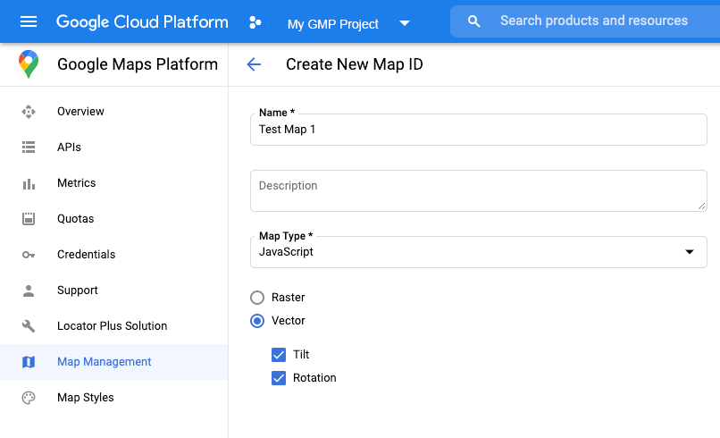
Pour créer un ID de carte, suivez les étapes décrites dans Personnalisation dans le cloud.
Définissez le type de carte sur JavaScript, puis sélectionnez l'option Vecteur.
Indiquez un ID de carte à l'aide de la propriété mapId lorsque vous instanciez la carte.
L'ID de carte doit correspondre au style de carte associé à l'ensemble de données à afficher.
Pour utiliser le style basé sur les données pour les ensembles de données, vous devez d'abord charger l'API Maps JavaScript en ajoutant le chargeur d'amorçage intégré au code de votre application, comme illustré ci-dessous (utilisez v=beta dans le tag script de votre API) :
<script>
(g=>{varh,a,k,p="The Google Maps JavaScript API",c="google",l="importLibrary",q="__ib__",m=document,b=window;b=b[c]||(b[c]={});vard=b.maps||(b.maps={}),r=newSet,e=newURLSearchParams,u=()=>h||(h=newPromise(async(f,n)=>{await(a=m.createElement("script"));e.set("libraries",[...r]+"");for(king)e.set(k.replace(/[A-Z]/g,t=>"_"+t[0].toLowerCase()),g[k]);e.set("callback",c+".maps."+q);a.src=`https://maps.${c}apis.com/maps/api/js?`+e;d[q]=f;a.onerror=()=>h=n(Error(p+" could not load."));a.nonce=m.querySelector("script[nonce]")?.nonce||"";m.head.append(a)}));d[l]?console.warn(p+" only loads once. Ignoring:",g):d[l]=(f,...n)=>r.add(f)&&u().then(()=>d[l](f,...n))})({key:"YOUR_API_KEY",v:"weekly",// Use the 'v' parameter to indicate the version to use (weekly, beta, alpha, etc.).// Add other bootstrap parameters as needed, using camel case.});
</script>
Vérifier les fonctionnalités de la carte (facultatif)
Le style basé sur les données pour les ensembles de données nécessite un ID de carte. S'il est manquant ou si un ID de carte non valide est transmis, les éléments géographiques de données ne pourront pas être chargés. Pour résoudre ce problème, vous pouvez ajouter un écouteur mapcapabilities_changed pour vous abonner aux modifications des capacités de la carte. Il indique si les conditions suivantes sont remplies :
Un ID de carte valide est utilisé.
L'ID de carte est associé à une carte vectorielle.
Utiliser des fonctionnalités de la carte est facultatif et n'est recommandé que pour les tests, le dépannage ou une exécution de secours.
// Optional: subscribe to map capability changes.map.addListener('mapcapabilities_changed',()=>{constmapCapabilities=map.getMapCapabilities();if(!mapCapabilities.isDataDrivenStylingAvailable){// Data-driven styling is *not* available, add a fallback.// Existing feature layers are also unavailable.}});
Sauf indication contraire, le contenu de cette page est régi par une licence Creative Commons Attribution 4.0, et les échantillons de code sont régis par une licence Apache 2.0. Pour en savoir plus, consultez les Règles du site Google Developers. Java est une marque déposée d'Oracle et/ou de ses sociétés affiliées.
Dernière mise à jour le 2025/09/05 (UTC).
[[["Facile à comprendre","easyToUnderstand","thumb-up"],["J'ai pu résoudre mon problème","solvedMyProblem","thumb-up"],["Autre","otherUp","thumb-up"]],[["Il n'y a pas l'information dont j'ai besoin","missingTheInformationINeed","thumb-down"],["Trop compliqué/Trop d'étapes","tooComplicatedTooManySteps","thumb-down"],["Obsolète","outOfDate","thumb-down"],["Problème de traduction","translationIssue","thumb-down"],["Mauvais exemple/Erreur de code","samplesCodeIssue","thumb-down"],["Autre","otherDown","thumb-down"]],["Dernière mise à jour le 2025/09/05 (UTC)."],[[["\u003cp\u003eTo utilize data-driven styling for datasets, obtain an API key, enable necessary APIs (Maps JavaScript API and Maps Datasets API), and create a map ID associated with a vector-based map style.\u003c/p\u003e\n"],["\u003cp\u003eInitialization involves providing the map ID during map instantiation and loading the Maps JavaScript API with the \u003ccode\u003ev=beta\u003c/code\u003e parameter in the script tag.\u003c/p\u003e\n"],["\u003cp\u003eFor troubleshooting, optionally use the \u003ccode\u003emapcapabilities_changed\u003c/code\u003e listener to verify map capabilities, such as a valid map ID linked to a vector map, ensuring data-driven styling functionality.\u003c/p\u003e\n"],["\u003cp\u003eAfter setup, proceed to create and upload a dataset to leverage data-driven styling within your maps.\u003c/p\u003e\n"]]],["To utilize data-driven styling, first get an API key and enable the Maps JavaScript and Datasets APIs. Create a map ID of type \"JavaScript\" and \"Vector,\" then associate it with a new map style. In the map initialization code, use the `mapId` property with your created ID and load the Maps JavaScript API with an inline bootstrap loader. Optionally, use a `mapcapabilities_changed` listener to ensure a valid map ID is used and troubleshoot any issues.\n"],null,["Select platform: [Android](/maps/documentation/android-sdk/dds-datasets/start \"View this page for the Android platform docs.\") [iOS](/maps/documentation/ios-sdk/dds-datasets/start \"View this page for the iOS platform docs.\") [JavaScript](/maps/documentation/javascript/dds-datasets/start \"View this page for the JavaScript platform docs.\")\n\n\u003cbr /\u003e\n\nFollow these steps to get set up with the data-driven styling for datasets.\n\nGet an API key and enable APIs\n\nBefore using the data-driven styling for datasets, you need:\nGoogle Cloud project with a billing account, and both the\nMaps JavaScript API and the Maps Datasets API enabled.\nTo learn more, see\n[Set up your Google Cloud project](/maps/documentation/javascript/cloud-setup).\n\n[Get an API key](/maps/documentation/javascript/get-api-key)\n\n\n[Enable the Maps JavaScript API](https://console.cloud.google.com/apis/library/maps-backend.googleapis.com)\n\n\n[Enable the Maps Datasets API](https://console.cloud.google.com/apis/library/mapsplatformdatasets.googleapis.com)\n\nCreate a map ID\n\nTo create a new [map ID](/maps/documentation/javascript/map-ids/mapid-over),\nfollow the steps in\n[Cloud customization](/maps/documentation/javascript/map-ids/get-map-id).\nSet the Map type to **JavaScript** , and select the **Vector** option.\n\nProvide a map ID using the `mapId` property when you instantiate the map .\nThe map ID must correspond to the map style that is associated with the dataset\nto display. \n\n```javascript\nconst position = new google.maps.LatLng(40.75, -74.05);\nconst map = new google.maps.Map(document.getElementById('map'), {\n zoom: 11,\n center: position,\n mapId: 'YOUR_MAP_ID',\n});\n```\n\nCreate a new map style\n\nTo create a new map style, follow the instructions in\n[Create and use map styles](/maps/documentation/javascript/cloud-customization/map-styles-leg)\nto create the style, and\n[associate the style with the map ID you just created](/maps/documentation/javascript/cloud-customization/map-styles-leg#associate-style-with-map-id).\n\nUpdate your map initialization code\n\nTo use the data-driven styling for datasets, first load the\nMaps JavaScript API, by adding the inline bootstrap loader to\nyour application code, as shown here\n(use `v=beta` in your API `script` tag): \n\n```javascript\n\u003cscript\u003e\n (g=\u003e{var h,a,k,p=\"The Google Maps JavaScript API\",c=\"google\",l=\"importLibrary\",q=\"__ib__\",m=document,b=window;b=b[c]||(b[c]={});var d=b.maps||(b.maps={}),r=new Set,e=new URLSearchParams,u=()=\u003eh||(h=new Promise(async(f,n)=\u003e{await (a=m.createElement(\"script\"));e.set(\"libraries\",[...r]+\"\");for(k in g)e.set(k.replace(/[A-Z]/g,t=\u003e\"_\"+t[0].toLowerCase()),g[k]);e.set(\"callback\",c+\".maps.\"+q);a.src=`https://maps.${c}apis.com/maps/api/js?`+e;d[q]=f;a.onerror=()=\u003eh=n(Error(p+\" could not load.\"));a.nonce=m.querySelector(\"script[nonce]\")?.nonce||\"\";m.head.append(a)}));d[l]?console.warn(p+\" only loads once. Ignoring:\",g):d[l]=(f,...n)=\u003er.add(f)&&u().then(()=\u003ed[l](f,...n))})({\n key: \"YOUR_API_KEY\",\n v: \"weekly\",\n // Use the 'v' parameter to indicate the /maps/documentation/javascript/versions to use (weekly, beta, alpha, etc.).\n // Add other /maps/documentation/javascript/load-maps-js-api#required_parameters as needed, using camel case.\n });\n\u003c/script\u003e\n```\n\nCheck map capabilities (optional)\n\nData-driven styling for datasets requires a map ID. If the map ID is missing,\nor an invalid map ID is passed, data features cannot load. As a\ntroubleshooting step, you can add a `mapcapabilities_changed` listener to\nsubscribe to map capability changes. This will indicate whether the following\nconditions have been met:\n\n- A valid map ID is in use.\n- The map ID is associated with a vector map.\n\nUsing Map Capabilities is optional, and recommended only for testing and\ntroubleshooting purposes, or for runtime fallback purposes. \n\n```javascript\n// Optional: subscribe to map capability changes.\nmap.addListener('mapcapabilities_changed', () =\u003e {\n const mapCapabilities = map.getMapCapabilities();\n\n if (!mapCapabilities.isDataDrivenStylingAvailable) {\n // Data-driven styling is *not* available, add a fallback.\n // Existing feature layers are also unavailable.\n }\n});\n```\n\nNext steps\n\n- [Create and upload a dataset](/maps/documentation/javascript/dds-datasets/create-dataset)"]]