Wenn Sie datengestützte Stile für Grenzen nutzen möchten, müssen Sie eine Karten-ID erstellen, die die JavaScript-Vektorkarte verwendet. Danach erstellen Sie einen neuen Kartenstil, wählen die Featureebenen für die Grenzen aus und verknüpfen den Stil mit Ihrer Karten-ID.
Karten-ID erstellen
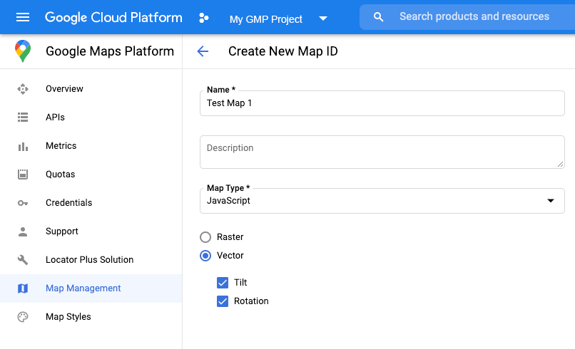
Eine Anleitung zum Erstellen einer Karten-ID finden Sie unter Cloudbasiertes Gestalten von Karteninhalten.
Legen Sie als Kartentyp JavaScript fest und wählen Sie die Option Vektor aus.
Setzen Sie ein Häkchen bei Neigung und Drehung, um Neigung und Drehung auf der Karte zu aktivieren. Wenn sich die Verwendung dieser Optionen negativ auf Ihre App auswirkt, lassen Sie Neigung und Drehung deaktiviert, damit Nutzer die Karte nicht neigen und drehen können.
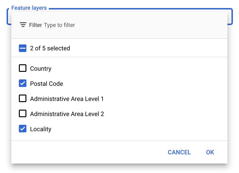
In der Google API Console können Sie auswählen, welche Elementebenen angezeigt werden sollen. So wird definiert, welche Arten von Grenzen auf der Karte zu sehen sind (z. B. für Orte oder Bundesländer).
Elementebenen verwalten
Rufen Sie in der Google Cloud Console die Seite Kartenstile auf.
Wählen Sie ein Projekt aus, wenn Sie dazu aufgefordert werden.
Wählen Sie einen Kartenstil aus.
Klicken Sie auf das Drop-down-Menü Elementebenen, um Ebenen hinzuzufügen oder zu entfernen.
Klicken Sie auf Speichern, um Ihre Änderungen zu speichern und für Ihre Karten verfügbar zu machen.
Initialisierungscode der Karte aktualisieren
Dazu ist die soeben erstellte Karten-ID erforderlich. Sie finden sie auf der Seite Kartenverwaltung.
Um die Maps JavaScript API zu laden, fügen Sie das Inline-Bootstrap-Ladeprogramm in Ihren Anwendungscode ein, wie im folgenden Snippet gezeigt:
<script>
(g=>{varh,a,k,p="The Google Maps JavaScript API",c="google",l="importLibrary",q="__ib__",m=document,b=window;b=b[c]||(b[c]={});vard=b.maps||(b.maps={}),r=newSet,e=newURLSearchParams,u=()=>h||(h=newPromise(async(f,n)=>{await(a=m.createElement("script"));e.set("libraries",[...r]+"");for(king)e.set(k.replace(/[A-Z]/g,t=>"_"+t[0].toLowerCase()),g[k]);e.set("callback",c+".maps."+q);a.src=`https://maps.${c}apis.com/maps/api/js?`+e;d[q]=f;a.onerror=()=>h=n(Error(p+" could not load."));a.nonce=m.querySelector("script[nonce]")?.nonce||"";m.head.append(a)}));d[l]?console.warn(p+" only loads once. Ignoring:",g):d[l]=(f,...n)=>r.add(f)&&u().then(()=>d[l](f,...n))})({key:"YOUR_API_KEY",v:"weekly",// Use the 'v' parameter to indicate the version to use (weekly, beta, alpha, etc.).// Add other bootstrap parameters as needed, using camel case.});
</script>
Geben Sie eine Karten-ID an, wenn Sie die Karte mit der Eigenschaft mapId instanziieren.
Dies sollte die Karten-ID sein, die Sie mit einem Kartenstil mit aktivierten Elementebenen konfiguriert haben.
map=newgoogle.maps.Map(document.getElementById('map'),{center:{lat:-34.397,lng:150.644},zoom:8,mapId:'MAP_ID'// A map ID using a style with one or more feature layers enabled.});
Um einen Verweis auf eine Elementebene auf Ihrer Karte zu erhalten, rufen Sie beim Initialisieren der Karte map.getFeatureLayer() auf:
functioninitMap(){map=newgoogle.maps.Map(document.getElementById("map"),{center:{lat:20.773,lng:-156.01},zoom:12,mapId:'MAP_ID',});// Add a feature layer for localities.localityLayer=map.getFeatureLayer('LOCALITY');...}
Kartenfunktionen prüfen
Für datengestützte Stile für Grenzen sind Funktionen erforderlich, die in der Google API Console aktiviert und einer Karten-ID zugeordnet werden. Karten-IDs sind kurzlebig und können sich ändern. Daher können Sie map.getMapCapabilities() aufrufen, um zu prüfen, ob eine bestimmte Funktion (z. B. datengestützte Stile) verfügbar ist, bevor Sie sie aufrufen. Diese Prüfung ist optional.
Im folgenden Beispiel wird veranschaulicht, wie Sie einen Listener hinzufügen, um über Änderungen der Kartenfunktionen informiert zu werden:
// subscribe to changesmap.addListener('mapcapabilities_changed',()=>{constmapCapabilities=map.getMapCapabilities();if(!mapCapabilities.isDataDrivenStylingAvailable){// Data-driven styling is *not* available, add a fallback.// Existing feature layers are also unavailable.}});
[[["Leicht verständlich","easyToUnderstand","thumb-up"],["Mein Problem wurde gelöst","solvedMyProblem","thumb-up"],["Sonstiges","otherUp","thumb-up"]],[["Benötigte Informationen nicht gefunden","missingTheInformationINeed","thumb-down"],["Zu umständlich/zu viele Schritte","tooComplicatedTooManySteps","thumb-down"],["Nicht mehr aktuell","outOfDate","thumb-down"],["Problem mit der Übersetzung","translationIssue","thumb-down"],["Problem mit Beispielen/Code","samplesCodeIssue","thumb-down"],["Sonstiges","otherDown","thumb-down"]],["Zuletzt aktualisiert: 2025-09-05 (UTC)."],[[["\u003cp\u003eData-driven styling for boundaries requires a JavaScript vector map with a custom style associated with a map ID.\u003c/p\u003e\n"],["\u003cp\u003eYou can select specific boundary feature layers (like localities or states) to display in the Google API Console to optimize performance.\u003c/p\u003e\n"],["\u003cp\u003eInitialize your map with the designated map ID and API key, ensuring they are linked to the same Google Cloud project.\u003c/p\u003e\n"],["\u003cp\u003eUtilize \u003ccode\u003emap.getFeatureLayer()\u003c/code\u003e to access and interact with specific feature layers on your map.\u003c/p\u003e\n"],["\u003cp\u003eVerify the availability of data-driven styling by using \u003ccode\u003emap.getMapCapabilities()\u003c/code\u003e before implementation.\u003c/p\u003e\n"]]],["To utilize data-driven styling for boundaries, first, create a JavaScript vector map ID in the Google API Console. Next, create a new map style and associate it with the map ID, selecting the desired boundary feature layers. Then, update your map initialization code with the new map ID. Ensure your map ID and API key are linked to the same project. Finally, use `map.getFeatureLayer()` to reference feature layers and `map.getMapCapabilities()` to check styling availability.\n"],null,["Select platform: [Android](/maps/documentation/android-sdk/dds-boundaries/start \"View this page for the Android platform docs.\") [iOS](/maps/documentation/ios-sdk/dds-boundaries/start \"View this page for the iOS platform docs.\") [JavaScript](/maps/documentation/javascript/dds-boundaries/start \"View this page for the JavaScript platform docs.\")\n\n\u003cbr /\u003e\n\nTo use data-driven styling for boundaries you must create a map ID that uses the\nJavaScript vector map. Next, you must create a new map style, select the\nboundary feature layers, and associate the style with your map ID.\n\nCreate a map ID\n\nTo create a new [map ID](/maps/documentation/get-map-id), follow the steps in\n[Cloud customization](/maps/documentation/javascript/cloud-customization).\nSet the Map type to **JavaScript** , and select the **Vector** option.\nCheck **Tilt** and **Rotation** to enable tilt and rotation on the map. If\nthe use of tilt or heading adversely affects your app, leave **Tilt** and\n**Rotation** un-checked so users cannot adjust them.\n\nCreate a new map style\n\nTo create a new map style, follow the instructions in\n[Manage map styles](/maps/documentation/javascript/cloud-customization/map-styles-leg)\nto create the style, and\n[associate the style with the map ID you just created](/maps/documentation/javascript/cloud-customization/map-styles-leg#associate-style-with-map-id).\n| **Experimental:** This feature can only be set for light map styles. When you link a light map style that has this feature enabled to a [map\n| ID](../map-ids/mapid-over), the enabled layers are also available for the dark map style.\n\nSelect feature layers\n\nIn the Google API Console you can select which feature layers to display. This\ndetermines which kinds of boundaries will appear on the map (for example\nlocalities, states, and so on).\n| **Important:** For optimal performance, only select the layers you need.\n\nTo manage feature layers\n\n1. In the Google API Console, [go to the Map Styles page](https://console.cloud.google.com/project/_/google/maps-apis/studio/styles).\n2. Select a project if prompted.\n3. Select a map style.\n4. Click the **Feature layers** drop-down to add or remove layers.\n5. Click **Save** to save your changes and make them available to your maps.\n\nUpdate your map initialization code\n\nThis requires the map ID you just created. It can be found on your [Maps\nManagement](https://console.cloud.google.com/google/maps-apis/studio/maps) page.\n| **Important:** Your map ID and API key must be associated with the same Google Cloud console project. Likewise, the map ID must be associated with a map style with one or more feature layers enabled.\n\n1. Load the Maps JavaScript API by adding the inline bootstrap loader to your application code, as shown in the following snippet:\n\n```javascript\n\u003cscript\u003e\n (g=\u003e{var h,a,k,p=\"The Google Maps JavaScript API\",c=\"google\",l=\"importLibrary\",q=\"__ib__\",m=document,b=window;b=b[c]||(b[c]={});var d=b.maps||(b.maps={}),r=new Set,e=new URLSearchParams,u=()=\u003eh||(h=new Promise(async(f,n)=\u003e{await (a=m.createElement(\"script\"));e.set(\"libraries\",[...r]+\"\");for(k in g)e.set(k.replace(/[A-Z]/g,t=\u003e\"_\"+t[0].toLowerCase()),g[k]);e.set(\"callback\",c+\".maps.\"+q);a.src=`https://maps.${c}apis.com/maps/api/js?`+e;d[q]=f;a.onerror=()=\u003eh=n(Error(p+\" could not load.\"));a.nonce=m.querySelector(\"script[nonce]\")?.nonce||\"\";m.head.append(a)}));d[l]?console.warn(p+\" only loads once. Ignoring:\",g):d[l]=(f,...n)=\u003er.add(f)&&u().then(()=\u003ed[l](f,...n))})({\n key: \"YOUR_API_KEY\",\n v: \"weekly\",\n // Use the 'v' parameter to indicate the /maps/documentation/javascript/versions to use (weekly, beta, alpha, etc.).\n // Add other /maps/documentation/javascript/load-maps-js-api#required_parameters as needed, using camel case.\n });\n\u003c/script\u003e\n```\n| **Note:** As the developer of a Maps JavaScript API application it is your responsibility to verify that your application complies with local laws by verifying that the correct region localization is applied for the country in which the application is hosted.\n\n1. Provide a map ID when you instantiate the map using the `mapId` property.\n This should be the map ID that you configured using a map style with feature\n layers enabled.\n\n ```javascript\n map = new\n google.maps.Map(document.getElementById('map'), {\n center: {lat: -34.397, lng: 150.644},\n zoom: 8,\n mapId: '\u003cvar translate=\"no\"\u003eMAP_ID\u003c/var\u003e' // A map ID using a style with one or more feature layers enabled.\n });\n ```\n\nLearn more about [loading the Maps JavaScript API](/maps/documentation/javascript/load-maps-js-api).\n\nAdd feature layers to a map\n\nTo get a reference to a feature layer on your map, call `map.getFeatureLayer()`\nwhen the map initializes: \n\n```javascript\nfunction initMap() {\n map = new google.maps.Map(document.getElementById(\"map\"), {\n center: { lat: 20.773, lng: -156.01 },\n zoom: 12,\n mapId: 'MAP_ID',\n });\n\n // Add a feature layer for localities.\n localityLayer = map.getFeatureLayer('LOCALITY');\n ...\n}\n```\n\nCheck map capabilities\n\nData-driven styling for boundaries requires capabilities which are enabled in the\nGoogle API Console, and associated with a map ID. Because map IDs are ephemeral\nand subject to change, you can call `map.getMapCapabilities()`\nto verify whether a certain capability (for example data-driven styling) is\navailable prior to calling it. This check is optional.\n\nThe following example shows adding a listener to subscribe to map capability\nchanges: \n\n```javascript\n// subscribe to changes\nmap.addListener('mapcapabilities_changed', () =\u003e {\n const mapCapabilities = map.getMapCapabilities();\n\n if (!mapCapabilities.isDataDrivenStylingAvailable) {\n // Data-driven styling is *not* available, add a fallback.\n // Existing feature layers are also unavailable.\n }\n});\n```\n\nNext steps\n\n- [Style a boundary polygon](/maps/documentation/javascript/dds-boundaries/style-polygon)\n- [Make a choropleth map](/maps/documentation/javascript/dds-boundaries/choropleth-map)\n- [Handle mouse events](/maps/documentation/javascript/dds-boundaries/handle-events)\n- [Get a place ID for a region](/maps/documentation/javascript/dds-boundaries/dds-use-maps-places-apis#use_to_find_a_region)\n- [Use the Geocoding and Places APIs with data-driven styling for boundaries](/maps/documentation/javascript/dds-boundaries/dds-use-maps-places-apis)"]]