Le mappe visualizzate tramite le mappe 3D fotorealistiche nell'API Maps JavaScript contengono elementi dell'interfaccia utente per supportare
l'interazione dell'utente con la mappa. Questi elementi sono noti come controlli e puoi scegliere di includerli o meno nell'interfaccia utente. Se disattivi i controlli dell'interfaccia utente,
l'utente può comunque navigare nella mappa utilizzando le scorciatoie da tastiera.
Le mappe 3D fotorealistiche nell'API Maps JavaScript supportano anche la guida degli utenti sulla mappa utilizzando
percorsi della videocamera preimpostati. Questi percorsi possono essere personalizzati e combinati per creare esperienze 3D avanzate.
Controlli di esplorazione
L'immagine seguente mostra il set predefinito di controlli visualizzati dalle
mappe 3D fotorealistiche nell'API Maps JavaScript:
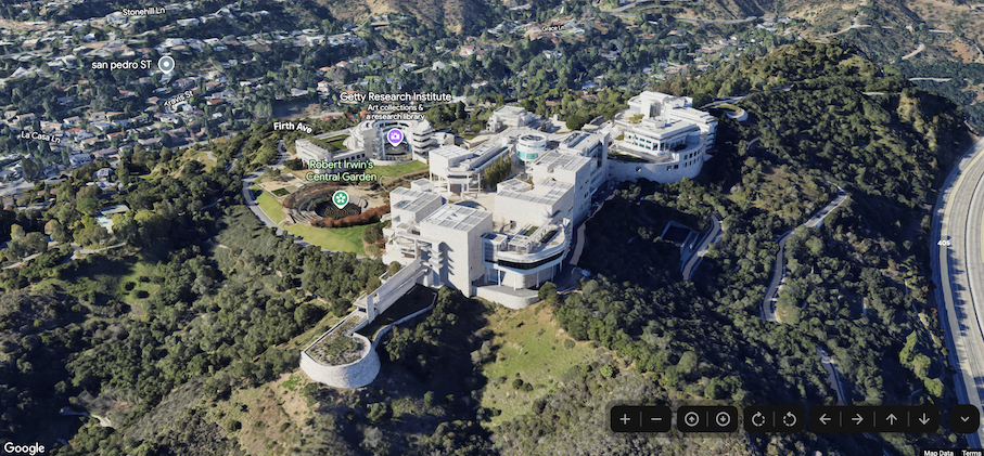
Di seguito è riportato un elenco completo dei controlli nelle mappe 3D fotorealistiche in Maps JavaScript:
Il controllo dello zoom mostra i pulsanti "+" e "-" per modificare il livello di zoom della mappa.
Il controllo dell'inclinazione ti consente di modificare l'inclinazione della videocamera.
Il controllo di rotazione ti consente di modificare l'orientamento della videocamera.
Il controllo Sposta mostra i pulsanti "←", "→", "↑" e "↓" per modificare
il centro della mappa.
Il seguente esempio di codice mostra l'attivazione/disattivazione dei controlli di esplorazione:
Le mappe 3D fotorealistiche in Maps JavaScript forniscono due percorsi della videocamera preimpostati. I percorsi della videocamera possono essere
personalizzati modificando la durata dell'animazione (aumentando o
diminuendo la velocità) o combinandoli per creare esperienze più cinematografiche.
Le mappe 3D fotorealistiche in Maps JavaScript supportano i seguenti percorsi della videocamera:
L'animazione flyCameraTo vola dal centro della mappa a una destinazione specificata.
L'animazione flyCameraAround ruota attorno a un punto della mappa per il numero di giri specificato.
I due percorsi disponibili possono essere combinati per volare verso un punto di interesse, ruotare
intorno a esso e poi fermarsi quando specificato.
Vai su
Il seguente esempio di codice mostra come animare la videocamera per raggiungere una
posizione:
Il seguente esempio di codice mostra come combinare le animazioni per spostare la videocamera in una posizione e poi ruotare intorno alla posizione al termine della prima animazione:
[[["Facile da capire","easyToUnderstand","thumb-up"],["Il problema è stato risolto","solvedMyProblem","thumb-up"],["Altra","otherUp","thumb-up"]],[["Mancano le informazioni di cui ho bisogno","missingTheInformationINeed","thumb-down"],["Troppo complicato/troppi passaggi","tooComplicatedTooManySteps","thumb-down"],["Obsoleti","outOfDate","thumb-down"],["Problema di traduzione","translationIssue","thumb-down"],["Problema relativo a esempi/codice","samplesCodeIssue","thumb-down"],["Altra","otherDown","thumb-down"]],["Ultimo aggiornamento 2025-07-22 UTC."],[],[],null,["Select platform: [Android](/maps/documentation/maps-3d/android-sdk/configure-camera-controls \"View this page for the Android platform docs.\") [iOS](/maps/documentation/maps-3d/ios-sdk/configure-camera-controls \"View this page for the iOS platform docs.\") [JavaScript](/maps/documentation/javascript/3d/map-controls \"View this page for the JavaScript platform docs.\")\n\n\u003cbr /\u003e\n\n\u003cbr /\u003e\n\n| This product or feature is in Preview (pre-GA). Pre-GA products and features might have limited support, and changes to pre-GA products and features might not be compatible with other pre-GA versions. Pre-GA Offerings are covered by the [Google\n| Maps Platform Service Specific Terms](https://cloud.google.com/maps-platform/terms/maps-service-terms). For more information, see the [launch stage\n| descriptions](/maps/launch-stages).\n\n\u003cbr /\u003e\n\nControls Overview\n\nThe maps displayed through the Photorealistic 3D Maps in Maps JavaScript API contain UI elements to support\nuser interaction with the map. These elements are known as *controls* and you\ncan elect to include them in the UI, or not to. If you suppress the UI controls,\nthe user can still navigate around the map using keyboard shortcuts.\n\nThe Photorealistic 3D Maps in Maps JavaScript API also supports guiding your users around the map using\npreset camera paths. These paths can be customized and combined to create rich\n3D experiences.\n| **Tip:** To enforce restrictions on the latitude, longitude, and camera behavior, see [Control the map and camera](/maps/documentation/javascript/3d/interaction).\n\nExploration controls\n\nThe following image shows the default set of controls displayed by the\nPhotorealistic 3D Maps in Maps JavaScript API:\n\nBelow is a list of the full set of controls in the Photorealistic 3D Maps in Maps JavaScript:\n\n- The **Zoom control** displays \"+\" and \"-\" buttons for changing the zoom level of the map.\n- The **Tilt control** lets you change the camera's tilt.\n- The **Rotate control** lets you change the camera's heading.\n- The **Move control** displays \"←\", \"→\", \"↑\", and \"↓\" buttons for changing the center of the map.\n\nThe following code sample demonstrates toggling exploration controls: \n\nJavaScript \n\n const map = new Map3DElement({\n center: { lat: 37.819852, lng: -122.478549, altitude: 2000 },\n tilt: 75,\n heading: 330,\n mode: MapMode.SATELLITE,\n defaultUIDisabled: true,\n });\n\nHTML \n\n \u003cgmp-map-3d\n mode=\"hybrid\"\n range=\"639.274301042242\"\n tilt=\"64.92100184857551\"\n center=\"34.0768990953219,-118.47450491266041,292.9794737933403\"\n heading=\"-61.02026752077781\"\n default-ui-disabled\n \u003e\u003c/gmp-map-3d\u003e\n\nPreset camera paths\n\nPhotorealistic 3D Maps in Maps JavaScript provides two preset camera paths. The camera paths can be\ncustomized by changing the duration of the animation (thereby increasing or\ndecreasing speed), or by combining them to create more cinematic experiences.\n\nPhotorealistic 3D Maps in Maps JavaScript supports the following camera paths:\n\n- `flyCameraTo` animation flies from the map center to a specified destination.\n- `flyCameraAround` animation rotates around a point on the map the specified number of rounds.\n\nThe two available paths may be combined to fly to a point of interest, rotate\naround it, and then stop when specified.\n\nFly to\n\nThe following code sample demonstrates animating the camera to fly to a\nlocation: \n\n const map = document.querySelector('gmp-map-3d');\n\n async function init() {\n await google.maps.importLibrary('maps3d');\n\n map.flyCameraTo({\n endCamera: {\n center: { lat: 37.6191, lng: -122.3816 },\n tilt: 67.5,\n range: 1000\n },\n durationMillis: 5000\n });\n }\n\nFly around\n\nThe following code sample demonstrates animating the camera to fly around a\nlocation: \n\n const map = document.querySelector('gmp-map-3d');\n\n async function init() {\n await google.maps.importLibrary('maps3d');\n\n map.flyCameraAround({\n camera,\n durationMillis: 60000,\n rounds: 1\n });\n }\n\nCombine animations\n\nThe following code sample demonstrates combining animations to fly the camera to\na location, and then rotate around the location when the first animation ends: \n\n const map = document.querySelector('gmp-map-3d');\n\n async function init() {\n await google.maps.importLibrary('maps3d');\n\n map.flyCameraTo({\n endCamera: flyToCamera,\n durationMillis: 5000,\n });\n\n map.addEventListener('gmp-animation-end', () =\u003e {\n map.flyCameraAround({\n camera: flyToCamera,\n durationMillis: 60000,\n rounds: 1\n });\n }, {once: true});\n }\n\nNext steps\n\n- Learn how to [restrict the map and camera](/maps/documentation/javascript/3d/interaction).\n- Learn how to [listen for and handle user interaction](/maps/documentation/javascript/3d/map-events)."]]