ElevationElement הוא רכיב HTML שמציג באופן חזותי נתוני גובה של נקודה אחת או של קו פוליגוני. הוא מציג תרשים של הגובה לאורך הנתיב שמוגדר במאפיין
path עם מערך של קואורדינטות של קווי רוחב ואורך. פלחים של קווים עוברים אינטרפולציה בין הנקודות במערך, כך שגם מספר קטן של נקודות יניב גרף גבהים מפורט.
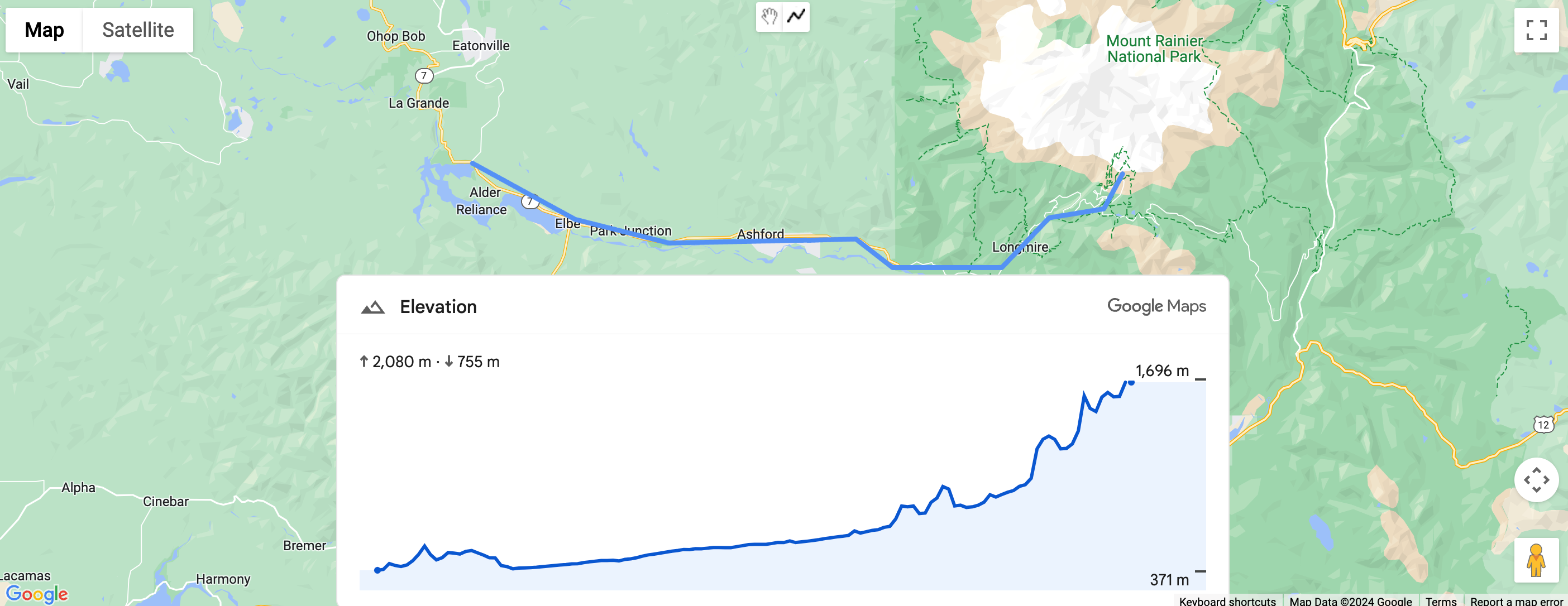
הגדרת הגובה של הנתיב באמצעות קואורדינטות
בדוגמה הבאה מוצג הגובה של נתיב בין שתי נקודות שנבחרו על ידי קבוצת קואורדינטות, באמצעות רכיב gmp-elevation.
הרכיב מוגדר למדידת מדדים באמצעות המאפיין
unit-system:
<gmp-elevation unit-system="metric"></gmp-elevation>
התג querySelector משמש לבחירת רכיב הגובה ולהגדרת המאפיין path שלו עם קואורדינטות של קו אורך וקו רוחב:
/** Maps JS loaded callback */
async function init() {
  // Load the Elevation Element from Maps JS
  const {ElevationElement} = await google.maps.importLibrary('elevation');

  // Specify an elevation path to render
  const elevationElement = document.querySelector('gmp-elevation');
  elevationElement.path = [
    {lat: 37.4523, lng: -122.2645},
    {lat: 37.377, lng: -122.4078},
  ];
}
קוד מלא לדוגמה
JavaScript
/** Maps JS loaded callback */
async function init() {
  // Load the Elevation Element from Maps JS
  const {ElevationElement} = await google.maps.importLibrary('elevation');

  // Specify an elevation path to render
  const elevationElement = document.querySelector('gmp-elevation');
  elevationElement.path = [
    {lat: 37.4523, lng: -122.2645},
    {lat: 37.377, lng: -122.4078},
  ];
}

init();
CSS
html, body {
  margin: 0;
  padding: 0;
}

gmp-elevation {
  width: 100%;
  height: 100%;
}

.overlay {
  margin: 20px;
  width: 400px;
}
HTML
<!DOCTYPE html>
<html>
  <head>
    <title>Simple Elevation</title>
    <meta charset="utf-8">
    <link rel="stylesheet" type="text/css" href="style.css">
  </head>
  <body>
    <h1>Path elevation</h1>
        <div class="overlay">
          <gmp-elevation unit-system="metric"></gmp-elevation>
        </div>
    <script>
      (g=>{var h,a,k,p="The Google Maps JavaScript API",c="google",l="importLibrary",q="__ib__",m=document,b=window;b=b[c]||(b[c]={});var d=b.maps||(b.maps={}),r=new Set,e=new URLSearchParams,u=()=>h||(h=new Promise(async(f,n)=>{await (a=m.createElement("script"));e.set("libraries",[...r]+"");for(k in g)e.set(k.replace(/[A-Z]/g,t=>"_"+t[0].toLowerCase()),g[k]);e.set("callback",c+".maps."+q);a.src=`https://maps.${c}apis.com/maps/api/js?`+e;d[q]=f;a.onerror=()=>h=n(Error(p+" could not load."));a.nonce=m.querySelector("script[nonce]")?.nonce||"";m.head.append(a)}));d[l]?console.warn(p+" only loads once. Ignoring:",g):d[l]=(f,...n)=>r.add(f)&&u().then(()=>d[l](f,...n))})({
        key: "YOUR_API_KEY",
        v: "alpha"
      });
    </script>
  </body>
</html>
הגדרת גובה של נתיב באמצעות קו פוליגוני
בדוגמה הבאה מוצגת הגובה של נתיב שמבוסס על קו פוליגוני שמשתמש צייר. היא מקבלת את
path מהקו המקוטע של המשתמש באמצעות polyline.getPath().getArray():
elevationElem.path = polyline.getPath().getArray();
קוד מלא לדוגמה
JavaScript
const map = document.querySelector('gmp-map');
const elevationElem = document.querySelector('gmp-elevation');

async function init() {
  await google.maps.importLibrary('places');
  await google.maps.importLibrary('marker');
  await google.maps.importLibrary('elevation');


  map.innerMap.setOptions({'mapTypeControl': true, 'clickableIcons': false});

  findCurrentLocation();
  drawPolyline();
}

async function drawPolyline() {
  const {DrawingManager} = await google.maps.importLibrary('drawing');
  const drawingManager = new DrawingManager({
    drawingMode: google.maps.drawing.OverlayType.POLYLINE,
    drawingControl: true,
    drawingControlOptions: {
      position: google.maps.ControlPosition.TOP_CENTER,
      drawingModes: [google.maps.drawing.OverlayType.POLYLINE]
    },
    polylineOptions: {geodesic: true, strokeColor: '#5491f5', strokeWeight: 6}
  });

  drawingManager.setMap(map.innerMap);

  drawingManager.addListener('polylinecomplete', (polyline) => {
    console.log('complete');
    console.log(polyline.getPath().getArray());
    elevationElem.path = polyline.getPath().getArray();
    polyline.addListener('click', (e) => {
      console.log(e);
    });
  });
}

async function findCurrentLocation() {
  const {LatLng} = await google.maps.importLibrary('core');
  if (navigator.geolocation) {
    navigator.geolocation.getCurrentPosition(
        (position) => {
          const pos =
              new LatLng(position.coords.latitude, position.coords.longitude);
          map.innerMap.panTo(pos);
          map.innerMap.setZoom(16);
        },
        () => {
          console.log('The Geolocation service failed.');
          map.innerMap.setZoom(16);
        },
    );
  } else {
    console.log(`Your browser doesn't support geolocation`);
    map.innerMap.setZoom(16);
  }
}

init();
CSS
html, body {
    height: 100%;
    margin: 0;
}

body {
    display: flex;
    flex-direction: column;
    font-family: Arial, Helvetica, sans-serif;
}

h1 {
    font-size: 16px;
    text-align: center;
}

gmp-map {
    box-sizing: border-box;
    margin-top: 20px;
    width: 100%;
    height: 100%;
}

gmp-elevation {
    width: 100%;
    height: 300px;
}

.overlay {
    width: 800px;
}
HTML
<!DOCTYPE html>
<html>
  <head>
    <title>Path Elevation</title>
    <meta charset="utf-8">
    <link rel="stylesheet" type="text/css" href="style.css">
  </head>
  <body>
    <h1>Draw polyline and get path elevation</h1>
    <gmp-map center="-37.813,144.963" zoom="12" map-id="DEMO_MAP_ID">
        <div id="elevation-container" class="overlay" slot="control-block-end-inline-center">
          <gmp-elevation unit-system="metric"></gmp-elevation>
        </div>
    </gmp-map>
    <script>
      (g=>{var h,a,k,p="The Google Maps JavaScript API",c="google",l="importLibrary",q="__ib__",m=document,b=window;b=b[c]||(b[c]={});var d=b.maps||(b.maps={}),r=new Set,e=new URLSearchParams,u=()=>h||(h=new Promise(async(f,n)=>{await (a=m.createElement("script"));e.set("libraries",[...r]+"");for(k in g)e.set(k.replace(/[A-Z]/g,t=>"_"+t[0].toLowerCase()),g[k]);e.set("callback",c+".maps."+q);a.src=`https://maps.${c}apis.com/maps/api/js?`+e;d[q]=f;a.onerror=()=>h=n(Error(p+" could not load."));a.nonce=m.querySelector("script[nonce]")?.nonce||"";m.head.append(a)}));d[l]?console.warn(p+" only loads once. Ignoring:",g):d[l]=(f,...n)=>r.add(f)&&u().then(()=>d[l](f,...n))})({
        key: "YOUR_API_KEY",
        v: "alpha"
      });
    </script>
  </body>
</html>