Чтобы использовать стили на основе данных для границ, необходимо создать идентификатор карты. Затем необходимо создать новый стиль карты, выбрать необходимые слои объектов границ и связать стиль с идентификатором карты.
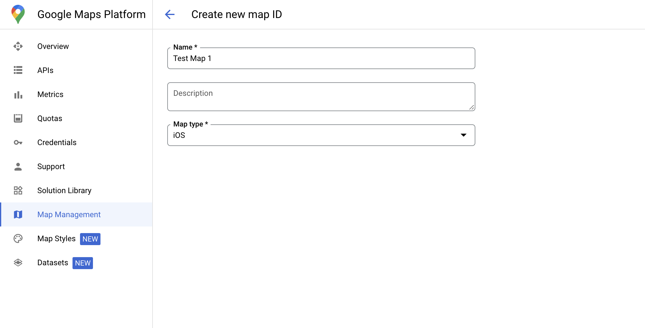
Создать идентификатор карты
MapID — это уникальный идентификатор, представляющий отдельный экземпляр карты Google. Вы можете создавать идентификаторы карт и обновлять стиль, связанный с идентификатором карты, в любое время в консоли Google Cloud.
Создать новый стиль карты
Чтобы создать новый стиль карты, следуйте инструкциям в разделе «Управление стилями карт» . После этого свяжите стиль с идентификатором только что созданной карты.
Выберите слои объектов
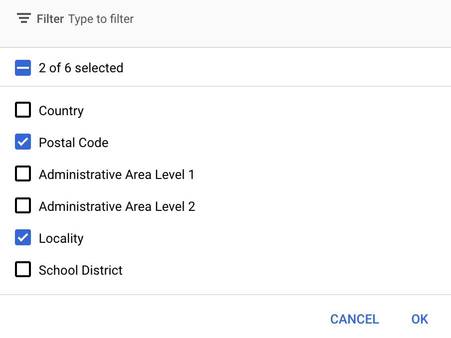
В консоли Google Cloud вы можете выбрать, какие слои объектов отображать. Это определяет, какие типы границ будут отображаться на карте (например, границы населённых пунктов, штатов и т. д.).
Нажмите раскрывающийся список Слои объектов , чтобы добавить или удалить слои.
Нажмите «Сохранить» , чтобы сохранить изменения и сделать их доступными для ваших карт.
Обновите код инициализации вашей карты.
Для этого шага необходимо связать идентификатор карты со стилем, в котором включен один или несколько слоёв объектов. Чтобы убедиться, что идентификатор карты правильно настроен в Cloud Console, проверьте, как он настроен в разделе «Управление картами» .
Быстрый
// A map ID using a style with one or more feature layers enabledletmapID=GMSMapID(identifier:"YOUR_MAP_ID")letmapView=GMSMapView(frame:.zero,mapID:mapID,camera:GMSCameraPosition(latitude:40,longitude:-80,zoom:7))
Objective-C
// A map ID using a style with one or more feature layers enabledGMSMapID*mapID=[GMSMapIDmapIDWithIdentifier:@"MAP_ID"];GMSMapView*mapView=[GMSMapViewmapWithFrame:CGRectZeromapID:mapIDcamera:[GMSCameraPositioncameraWithLatitude:40longitude:-80zoom:7]];
Добавить слои объектов на карту
Чтобы получить ссылку на слой объектов на карте, вызовите mapView.featureLayer(of:) при инициализации карты:
Для стилизации границ на основе данных требуются возможности, которые включены в консоли Google Cloud и связаны с идентификатором карты. Поскольку идентификаторы карт могут меняться, вы можете вызвать метод mapView.mapCapabilities для объекта GMSMapView , чтобы проверить доступность определённой возможности (например, стилизации на основе данных) перед её вызовом.
Вы также можете отслеживать изменения в возможностях карты, подписавшись на GMSViewDelegate . В этом примере показано, как использовать протокол для проверки требований к стилю, основанному на данных.
Быстрый
classSampleViewController:UIViewController{privatelazyvarmapView:GMSMapView=GMSMapView(frame:.zero,mapID:GMSMapID(identifier:"YOUR_MAP_ID"),camera:GMSCameraPosition(latitude:40,longitude:-80,zoom:7))overridefuncloadView(){self.view=mapViewmapView.delegate=self}}extensionSampleViewController:GMSMapViewDelegate{funcmapView(_mapView:GMSMapView,didChangemapCapabilities:GMSMapCapabilityFlags){if(!mapCapabilities.contains(.dataDrivenStyling)){// Data-driven styling is *not* available, add a fallback.// Existing feature layers are also unavailable.}}}
Objective-C
@interfaceSampleViewController: UIViewController<GMSMapViewDelegate>
@end@implementationSampleViewController-(void)loadView{GMSMapView*mapView=[GMSMapViewmapWithFrame:CGRectZeromapID:[GMSMapIDmapIDWithIdentifier:@"MAP_ID"]camera:[GMSCameraPositioncameraWithLatitude:40longitude:-80zoom:7]];mapView.delegete=self;self.view=mapView;}-(void)mapView:(GMSMapView*)mapViewdidChangeMapCapabilities:(GMSMapCapabilityFlags)mapCapabilities{if(!(mapCapabilities&GMSMapCapabilityFlagsDataDrivenStyling)){// Data-driven styling is *not* available, add a fallback.// Existing feature layers are also unavailable.}}@end
[[["Прост для понимания","easyToUnderstand","thumb-up"],["Помог мне решить мою проблему","solvedMyProblem","thumb-up"],["Другое","otherUp","thumb-up"]],[["Отсутствует нужная мне информация","missingTheInformationINeed","thumb-down"],["Слишком сложен/слишком много шагов","tooComplicatedTooManySteps","thumb-down"],["Устарел","outOfDate","thumb-down"],["Проблема с переводом текста","translationIssue","thumb-down"],["Проблемы образцов/кода","samplesCodeIssue","thumb-down"],["Другое","otherDown","thumb-down"]],["Последнее обновление: 2025-09-04 UTC."],[[["\u003cp\u003eData-driven styling for boundaries requires creating a map ID and associating it with a custom map style that includes selected feature layers.\u003c/p\u003e\n"],["\u003cp\u003eYou can manage feature layers, such as localities and states, in the Google Cloud console to control which boundaries are displayed.\u003c/p\u003e\n"],["\u003cp\u003eUpdate your map initialization code to use the map ID, ensuring data-driven styling is enabled for the map.\u003c/p\u003e\n"],["\u003cp\u003eUtilize \u003ccode\u003emapView.featureLayer(of:)\u003c/code\u003e to access specific feature layers on your map for further styling or interaction.\u003c/p\u003e\n"],["\u003cp\u003eVerify map capabilities, including data-driven styling, using \u003ccode\u003emapView.mapCapabilities\u003c/code\u003e or by subscribing to \u003ccode\u003eGMSViewDelegate\u003c/code\u003e to detect changes and implement fallbacks if needed.\u003c/p\u003e\n"]]],[],null,["Select platform: [Android](/maps/documentation/android-sdk/dds-boundaries/start \"View this page for the Android platform docs.\") [iOS](/maps/documentation/ios-sdk/dds-boundaries/start \"View this page for the iOS platform docs.\") [JavaScript](/maps/documentation/javascript/dds-boundaries/start \"View this page for the JavaScript platform docs.\")\n\n\u003cbr /\u003e\n\nTo use data-driven styling for boundaries you must create a map ID. Next, you\nmust create a new map style, select the needed boundary feature layers, and\nassociate the style with your map ID.\n\nCreate a map ID\n\nA [mapID](/maps/documentation/get-map-id) is a unique identifier that represents\na single instance of a Google Map. You can create map IDs and update a style\nassociated with a map ID at any time in the Google Cloud console.\n\nCreate a new map style\n\nTo create a new map style, follow the instructions in [Manage map\nstyles](/maps/documentation/ios-sdk/cloud-customization/map-styles) to create\nthe style. Once complete associate the style with the newly created map ID.\n| **Experimental:** This feature can only be set for light map styles. When you link a light map style that has this feature enabled to a [map\n| ID](../map-ids/mapid-over), the enabled layers are also available for the dark map style.\n\nSelect feature layers\n\nIn the Google Cloud console you can select which feature layers to display. This\ndetermines which kinds of boundaries appear on the map (for example localities,\nstates, and so on).\n| **Important:** For optimal performance, only select the layers you need.\n\nManage feature layers\n\n1. In the Google Cloud console, [go to the Map Styles\n page](https://console.cloud.google.com/project/_/google/maps-apis/studio/styles)\n\n2. Select a project if prompted.\n\n3. Select a map style.\n\n4. Click the **Feature layers** drop-down to add or remove layers.\n\n5. Click **Save** to save your changes and make them available to your maps.\n\nUpdate your map initialization code\n\nThis step requires a map ID be associated with a style with one or more feature\nlayers enabled. To verify your map ID is set up correctly in\nCloud console, review how it is configured under [Maps\nManagement](https://console.cloud.google.com/google/maps-apis/studio/maps). \n\nSwift \n\n```swift\n// A map ID using a style with one or more feature layers enabled\n\nlet mapID = GMSMapID(identifier: \"YOUR_MAP_ID\")\nlet mapView = GMSMapView(frame: .zero, mapID: mapID, camera: GMSCameraPosition(latitude: 40, longitude: -80, zoom: 7))\n```\n\nObjective-C \n\n```objective-c\n// A map ID using a style with one or more feature layers enabled\n\nGMSMapID *mapID = [GMSMapID mapIDWithIdentifier:@\"MAP_ID\"];\nGMSMapView *mapView = [GMSMapView mapWithFrame:CGRectZero mapID:mapID camera:[GMSCameraPosition cameraWithLatitude:40 longitude:-80 zoom:7]];\n```\n| **Important:** For testing, you can skip the step of creating and configuring a [map\n| ID](/maps/documentation/get-map-id), by using mapId: [`DEMO_MAP_ID`](/maps/documentation/ios-sdk/reference/objc/Classes/GMSMapID) in your app code. `DEMO_MAP_ID` is intended for testing purposes only. Don't use `DEMO_MAP_ID` in a production environment.\n\nAdd feature layers to a map\n\nTo get a reference to a feature layer on your map, call\n[`mapView.featureLayer(of:)`](/maps/documentation/ios-sdk/reference/objc/Classes/GMSMapView#-featurelayeroffeaturetype:)\nwhen the map initializes: \n\nSwift \n\n```swift\nlet layer = mapView.featureLayer(of: .locality)\n```\n\nObjective-C \n\n```objective-c\nGMSFeatureLayer *layer = [mapView featureLayerOfFeatureType:GMSFeatureTypeLocality];\n```\n\nCheck map capabilities\n\nData-driven styling for boundaries requires capabilities which are enabled in the\nGoogle Cloud console, and associated with a map ID. Because map IDs are subject to\nchange, you can call\n[`mapView.mapCapabilities`](/maps/documentation/ios-sdk/reference/objc/Classes/GMSMapView#mapcapabilities)\non a [`GMSMapView`](/maps/documentation/ios-sdk/reference/objc/Classes/GMSMapView) to verify whether a certain capability (for\nexample data-driven styling) is available prior to calling it.\n\nYou can also detect changes in map capabilities by subscribing to\n[`GMSViewDelegate`](/maps/documentation/ios-sdk/reference/objc/Protocols/GMSMapViewDelegate). This example shows how to use the\nprotocol to check for data-driven styling requirements. \n\nSwift \n\n```swift\nclass SampleViewController: UIViewController {\n\n private lazy var mapView: GMSMapView = GMSMapView(frame: .zero, mapID: GMSMapID(identifier: \"YOUR_MAP_ID\"), camera: GMSCameraPosition(latitude: 40, longitude: -80, zoom: 7))\n\n override func loadView() {\n self.view = mapView\n mapView.delegate = self\n }\n}\n\nextension SampleViewController: GMSMapViewDelegate {\n func mapView(_ mapView: GMSMapView, didChange mapCapabilities: GMSMapCapabilityFlags) {\n if (!mapCapabilities.contains(.dataDrivenStyling)) {\n // Data-driven styling is *not* available, add a fallback.\n // Existing feature layers are also unavailable.\n }\n }\n}\n```\n\nObjective-C \n\n```objective-c\n@interface SampleViewController: UIViewController \u003cGMSMapViewDelegate\u003e\n@end\n\n@implementation SampleViewController\n- (void)loadView {\n GMSMapView *mapView = [GMSMapView mapWithFrame:CGRectZero mapID:[GMSMapID mapIDWithIdentifier:@\"MAP_ID\"] camera:[GMSCameraPosition cameraWithLatitude:40 longitude:-80 zoom:7]];\n mapView.delegete = self;\n self.view = mapView;\n}\n\n- (void)mapView:(GMSMapView *)mapView didChangeMapCapabilities:(GMSMapCapabilityFlags)mapCapabilities {\n if (!(mapCapabilities & GMSMapCapabilityFlagsDataDrivenStyling)) {\n // Data-driven styling is *not* available, add a fallback.\n // Existing feature layers are also unavailable.\n }\n}\n@end\n```"]]