Pour utiliser le style basé sur les données pour les limites, vous devez créer un ID de carte. Ensuite, créez un style de carte, sélectionnez les calques d'éléments géographiques de votre choix et associez le style à l'ID de votre carte.
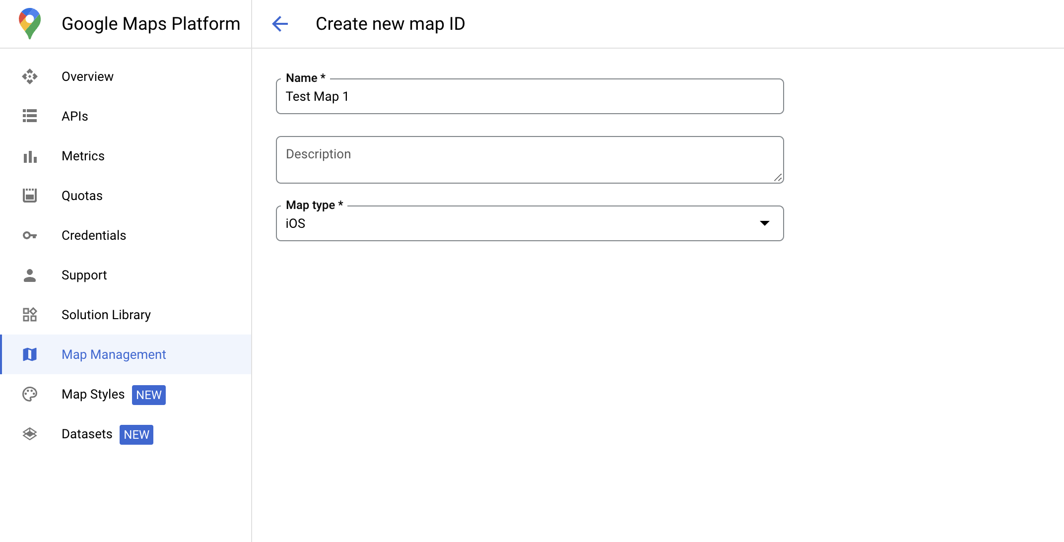
Créer un ID de carte
Un mapID est un identifiant unique qui représente une seule instance d'une carte Google. Vous pouvez créer des ID de carte et mettre à jour un style associé à un ID de carte à tout moment dans la console Google Cloud.
Créer un style de carte
Pour créer un style de carte, suivez les instructions de la section Gérer les styles de carte. Une fois le style créé, associez-le à l'ID de carte que vous venez de créer.
Sélectionner des calques d'éléments
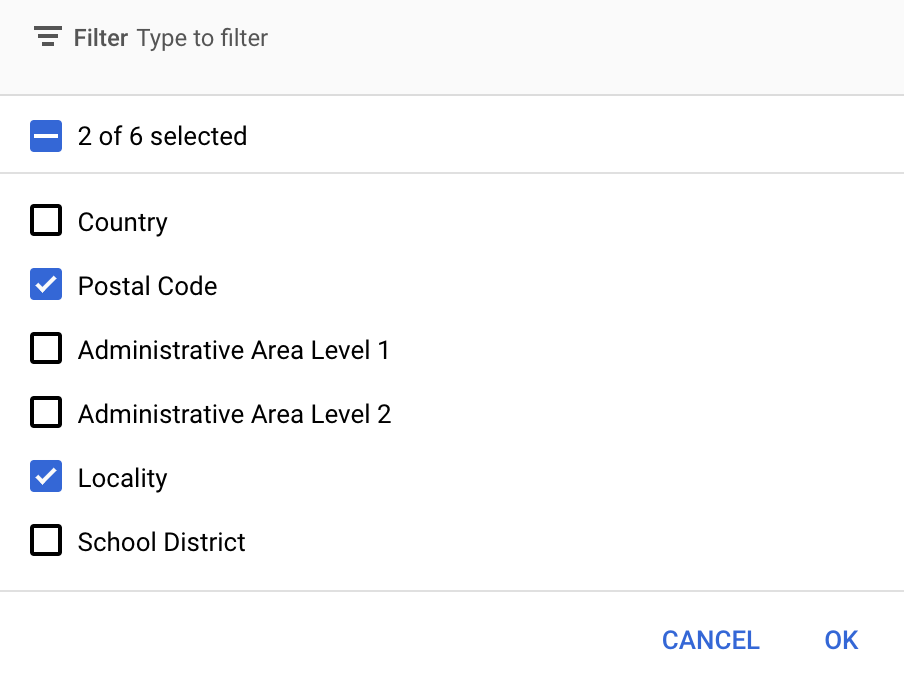
Dans la console Google Cloud, vous pouvez sélectionner les calques d'éléments à afficher. Cela permet de déterminer les types de limites qui s'afficheront sur la carte (par exemple, les localités, les États, etc.).
Cliquez sur le menu déroulant Calques d'éléments pour ajouter ou supprimer des calques.
Cliquez sur Enregistrer pour enregistrer vos modifications et les appliquer à vos cartes.
Modifier le code d'initialisation de la carte
Cette étape nécessite qu'un ID de carte soit associé à un style avec un ou plusieurs calques d'éléments activés. Pour vérifier que votre ID de carte est correctement configuré dans la console Cloud, vérifiez sa configuration sous Gestion des cartes.
Swift
// A map ID using a style with one or more feature layers enabledletmapID=GMSMapID(identifier:"YOUR_MAP_ID")letmapView=GMSMapView(frame:.zero,mapID:mapID,camera:GMSCameraPosition(latitude:40,longitude:-80,zoom:7))
Objective-C
// A map ID using a style with one or more feature layers enabledGMSMapID*mapID=[GMSMapIDmapIDWithIdentifier:@"MAP_ID"];GMSMapView*mapView=[GMSMapViewmapWithFrame:CGRectZeromapID:mapIDcamera:[GMSCameraPositioncameraWithLatitude:40longitude:-80zoom:7]];
Ajouter des calques d'éléments géographiques à une carte
Pour obtenir une référence à un calque d'éléments sur votre carte, appelez mapView.featureLayer(of:) lorsque la carte s'initialise :
Le style basé sur les données pour les limites nécessite des fonctionnalités activées dans la console Google Cloud et associées à un ID de carte. Les ID de carte étant susceptibles d'être modifiés, vous pouvez appeler mapView.mapCapabilities sur un GMSMapView pour vérifier si une fonctionnalité donnée (par exemple, les styles basés sur les données) est disponible avant de l'appeler.
Vous pouvez également détecter les modifications apportées aux fonctionnalités de la carte en vous abonnant à GMSViewDelegate. Cet exemple montre comment utiliser le protocole pour vérifier les exigences de style basées sur les données.
Swift
classSampleViewController:UIViewController{privatelazyvarmapView:GMSMapView=GMSMapView(frame:.zero,mapID:GMSMapID(identifier:"YOUR_MAP_ID"),camera:GMSCameraPosition(latitude:40,longitude:-80,zoom:7))overridefuncloadView(){self.view=mapViewmapView.delegate=self}}extensionSampleViewController:GMSMapViewDelegate{funcmapView(_mapView:GMSMapView,didChangemapCapabilities:GMSMapCapabilityFlags){if(!mapCapabilities.contains(.dataDrivenStyling)){// Data-driven styling is *not* available, add a fallback.// Existing feature layers are also unavailable.}}}
Objective-C
@interfaceSampleViewController: UIViewController<GMSMapViewDelegate>
@end@implementationSampleViewController-(void)loadView{GMSMapView*mapView=[GMSMapViewmapWithFrame:CGRectZeromapID:[GMSMapIDmapIDWithIdentifier:@"MAP_ID"]camera:[GMSCameraPositioncameraWithLatitude:40longitude:-80zoom:7]];mapView.delegete=self;self.view=mapView;}-(void)mapView:(GMSMapView*)mapViewdidChangeMapCapabilities:(GMSMapCapabilityFlags)mapCapabilities{if(!(mapCapabilities&GMSMapCapabilityFlagsDataDrivenStyling)){// Data-driven styling is *not* available, add a fallback.// Existing feature layers are also unavailable.}}@end
Sauf indication contraire, le contenu de cette page est régi par une licence Creative Commons Attribution 4.0, et les échantillons de code sont régis par une licence Apache 2.0. Pour en savoir plus, consultez les Règles du site Google Developers. Java est une marque déposée d'Oracle et/ou de ses sociétés affiliées.
Dernière mise à jour le 2025/09/05 (UTC).
[[["Facile à comprendre","easyToUnderstand","thumb-up"],["J'ai pu résoudre mon problème","solvedMyProblem","thumb-up"],["Autre","otherUp","thumb-up"]],[["Il n'y a pas l'information dont j'ai besoin","missingTheInformationINeed","thumb-down"],["Trop compliqué/Trop d'étapes","tooComplicatedTooManySteps","thumb-down"],["Obsolète","outOfDate","thumb-down"],["Problème de traduction","translationIssue","thumb-down"],["Mauvais exemple/Erreur de code","samplesCodeIssue","thumb-down"],["Autre","otherDown","thumb-down"]],["Dernière mise à jour le 2025/09/05 (UTC)."],[[["\u003cp\u003eData-driven styling for boundaries requires creating a map ID and associating it with a custom map style that includes selected feature layers.\u003c/p\u003e\n"],["\u003cp\u003eYou can manage feature layers, such as localities and states, in the Google Cloud console to control which boundaries are displayed.\u003c/p\u003e\n"],["\u003cp\u003eUpdate your map initialization code to use the map ID, ensuring data-driven styling is enabled for the map.\u003c/p\u003e\n"],["\u003cp\u003eUtilize \u003ccode\u003emapView.featureLayer(of:)\u003c/code\u003e to access specific feature layers on your map for further styling or interaction.\u003c/p\u003e\n"],["\u003cp\u003eVerify map capabilities, including data-driven styling, using \u003ccode\u003emapView.mapCapabilities\u003c/code\u003e or by subscribing to \u003ccode\u003eGMSViewDelegate\u003c/code\u003e to detect changes and implement fallbacks if needed.\u003c/p\u003e\n"]]],[],null,["Select platform: [Android](/maps/documentation/android-sdk/dds-boundaries/start \"View this page for the Android platform docs.\") [iOS](/maps/documentation/ios-sdk/dds-boundaries/start \"View this page for the iOS platform docs.\") [JavaScript](/maps/documentation/javascript/dds-boundaries/start \"View this page for the JavaScript platform docs.\")\n\n\u003cbr /\u003e\n\nTo use data-driven styling for boundaries you must create a map ID. Next, you\nmust create a new map style, select the needed boundary feature layers, and\nassociate the style with your map ID.\n\nCreate a map ID\n\nA [mapID](/maps/documentation/get-map-id) is a unique identifier that represents\na single instance of a Google Map. You can create map IDs and update a style\nassociated with a map ID at any time in the Google Cloud console.\n\nCreate a new map style\n\nTo create a new map style, follow the instructions in [Manage map\nstyles](/maps/documentation/ios-sdk/cloud-customization/map-styles) to create\nthe style. Once complete associate the style with the newly created map ID.\n| **Experimental:** This feature can only be set for light map styles. When you link a light map style that has this feature enabled to a [map\n| ID](../map-ids/mapid-over), the enabled layers are also available for the dark map style.\n\nSelect feature layers\n\nIn the Google Cloud console you can select which feature layers to display. This\ndetermines which kinds of boundaries appear on the map (for example localities,\nstates, and so on).\n| **Important:** For optimal performance, only select the layers you need.\n\nManage feature layers\n\n1. In the Google Cloud console, [go to the Map Styles\n page](https://console.cloud.google.com/project/_/google/maps-apis/studio/styles)\n\n2. Select a project if prompted.\n\n3. Select a map style.\n\n4. Click the **Feature layers** drop-down to add or remove layers.\n\n5. Click **Save** to save your changes and make them available to your maps.\n\nUpdate your map initialization code\n\nThis step requires a map ID be associated with a style with one or more feature\nlayers enabled. To verify your map ID is set up correctly in\nCloud console, review how it is configured under [Maps\nManagement](https://console.cloud.google.com/google/maps-apis/studio/maps). \n\nSwift \n\n```swift\n// A map ID using a style with one or more feature layers enabled\n\nlet mapID = GMSMapID(identifier: \"YOUR_MAP_ID\")\nlet mapView = GMSMapView(frame: .zero, mapID: mapID, camera: GMSCameraPosition(latitude: 40, longitude: -80, zoom: 7))\n```\n\nObjective-C \n\n```objective-c\n// A map ID using a style with one or more feature layers enabled\n\nGMSMapID *mapID = [GMSMapID mapIDWithIdentifier:@\"MAP_ID\"];\nGMSMapView *mapView = [GMSMapView mapWithFrame:CGRectZero mapID:mapID camera:[GMSCameraPosition cameraWithLatitude:40 longitude:-80 zoom:7]];\n```\n| **Important:** For testing, you can skip the step of creating and configuring a [map\n| ID](/maps/documentation/get-map-id), by using mapId: [`DEMO_MAP_ID`](/maps/documentation/ios-sdk/reference/objc/Classes/GMSMapID) in your app code. `DEMO_MAP_ID` is intended for testing purposes only. Don't use `DEMO_MAP_ID` in a production environment.\n\nAdd feature layers to a map\n\nTo get a reference to a feature layer on your map, call\n[`mapView.featureLayer(of:)`](/maps/documentation/ios-sdk/reference/objc/Classes/GMSMapView#-featurelayeroffeaturetype:)\nwhen the map initializes: \n\nSwift \n\n```swift\nlet layer = mapView.featureLayer(of: .locality)\n```\n\nObjective-C \n\n```objective-c\nGMSFeatureLayer *layer = [mapView featureLayerOfFeatureType:GMSFeatureTypeLocality];\n```\n\nCheck map capabilities\n\nData-driven styling for boundaries requires capabilities which are enabled in the\nGoogle Cloud console, and associated with a map ID. Because map IDs are subject to\nchange, you can call\n[`mapView.mapCapabilities`](/maps/documentation/ios-sdk/reference/objc/Classes/GMSMapView#mapcapabilities)\non a [`GMSMapView`](/maps/documentation/ios-sdk/reference/objc/Classes/GMSMapView) to verify whether a certain capability (for\nexample data-driven styling) is available prior to calling it.\n\nYou can also detect changes in map capabilities by subscribing to\n[`GMSViewDelegate`](/maps/documentation/ios-sdk/reference/objc/Protocols/GMSMapViewDelegate). This example shows how to use the\nprotocol to check for data-driven styling requirements. \n\nSwift \n\n```swift\nclass SampleViewController: UIViewController {\n\n private lazy var mapView: GMSMapView = GMSMapView(frame: .zero, mapID: GMSMapID(identifier: \"YOUR_MAP_ID\"), camera: GMSCameraPosition(latitude: 40, longitude: -80, zoom: 7))\n\n override func loadView() {\n self.view = mapView\n mapView.delegate = self\n }\n}\n\nextension SampleViewController: GMSMapViewDelegate {\n func mapView(_ mapView: GMSMapView, didChange mapCapabilities: GMSMapCapabilityFlags) {\n if (!mapCapabilities.contains(.dataDrivenStyling)) {\n // Data-driven styling is *not* available, add a fallback.\n // Existing feature layers are also unavailable.\n }\n }\n}\n```\n\nObjective-C \n\n```objective-c\n@interface SampleViewController: UIViewController \u003cGMSMapViewDelegate\u003e\n@end\n\n@implementation SampleViewController\n- (void)loadView {\n GMSMapView *mapView = [GMSMapView mapWithFrame:CGRectZero mapID:[GMSMapID mapIDWithIdentifier:@\"MAP_ID\"] camera:[GMSCameraPosition cameraWithLatitude:40 longitude:-80 zoom:7]];\n mapView.delegete = self;\n self.view = mapView;\n}\n\n- (void)mapView:(GMSMapView *)mapView didChangeMapCapabilities:(GMSMapCapabilityFlags)mapCapabilities {\n if (!(mapCapabilities & GMSMapCapabilityFlagsDataDrivenStyling)) {\n // Data-driven styling is *not* available, add a fallback.\n // Existing feature layers are also unavailable.\n }\n}\n@end\n```"]]