テーブル アセットのアップロード
アセット マネージャーまたはコマンドライン インターフェース(CLI)を使用して、シェープファイルまたは CSV 形式のデータセットをアップロードできます。(コードエディタまたは CLI を使用してラスター データをインポートする方法については、ラスターデータのインポートをご覧ください)。アップロードしたアセットは最初は非公開ですが、アセットの共有で説明されているように共有できます。
シェープファイルをアップロードする
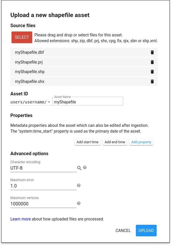
Code Editor からシェープファイルをアップロードするには、 ボタンをクリックし、[テーブルのアップロード] セクションで [シェープファイル] を選択します。図 1 のようなアップロード ダイアログが表示されます。[SELECT] ボタンをクリックし、ローカル ファイル システムにあるシェープファイルまたはシェープファイルを含む ZIP アーカイブに移動します。.shp ファイルを選択する際は、関連する .dbf、.shx、.prj ファイルも必ず選択してください。.prj ファイルが指定されていない場合、Earth Engine はデフォルトで WGS84(経度、緯度)座標を使用します。ZIP アーカイブをアップロードする場合は、シェープファイル(.shp、.dbf、.shx、.prj などのセット)が 1 つだけ含まれ、ファイル名が重複していないことを確認してください。ファイル名に余分なピリオドやドットが含まれていないことを確認します。(ファイル名の拡張子の前にピリオドが 1 つ付きます)。
ユーザー フォルダに、テーブルに適切なアセット ID(まだ存在しない ID)を指定します。[アップロード] をクリックしてアップロードを開始します。
CSV ファイルをアップロードする
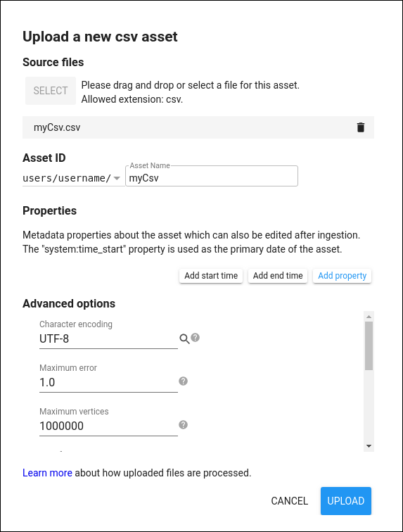
Code Editor から CSV をアップロードするには、[アセット] タブを有効にして ボタンをクリックし、[テーブルのアップロード] セクションで [CSV ファイル] を選択します。図 2 のようなアップロード ダイアログが表示されます。[SELECT] ボタンをクリックし、ローカル ファイル システムの .csv ファイルに移動します。テーブルに一意の関連するアセット ID 名を付けます。[OK] をクリックしてアップロードを開始します。
CSV ファイルには、特徴ごとに 1 行と、特徴セットのプロパティまたは変数の数と同じ数の列を含める必要があります。特徴が地理空間である場合は、ジオメトリ文字列(GeoJSON、WKT)または x と y の位置プロパティで定義された位置情報を指定する必要があります。CSV ファイルが GIS または GDAL/OGR などの地理空間データツールからエクスポートされたものである場合、適切な形式で名前が付けられたジオメトリ列がすでに存在している必要があります。または、スプレッドシート アプリケーションで、ポイントの位置を表す x 座標と y 座標の 2 つの列を定義し、他の変数とともに CSV 形式としてエクスポートすることもできます。
詳細オプション
アップロード ダイアログの [詳細オプション] セクションで、デフォルト設定を表示、変更します。頂点数の多いジオメトリを分割すると、Earth Engine のパフォーマンスを改善できます。Earth Engine では、100 万を超える頂点を持つ特徴は使用できません。テーブルのアップロード中に、100 万を超える頂点を持つジオメトリが自動的に分割されます。値を小さくすると、ベクター レンダリングのパフォーマンスが向上します。
Earth Engine はプライマリ ジオメトリ列の検出を試みます。特に指定しない限り、データ投影は WGS84 と見なされます。ジオメトリの測地線の状態は、指定された投影のデフォルトのエッジ解釈によって決まります(WGS84 では測地線ジオメトリが使用されます)。ただし、これは [詳細設定] メニューでオーバーライドできます。データのジオメトリが x 列と y 列で定義されたポイントの場合は、それぞれの列に「経度」と「緯度」という名前を付けるか、[詳細設定] で x 列と y 列の名前を指定してください。
アップロードの進行状況のトラッキング
テーブルのアップロードを開始すると、タスク マネージャーに「アセットの取り込み」タスクが追加されます。このタスク マネージャーは、Code Editor の右側にある [タスク] タブにあります。[?] をクリックしてアップロード ステータスを確認します。アイコンは、タスクにカーソルを合わせると表示されます。アップロードをキャンセルするには、タスクの横にある回転アイコン  をクリックします。取り込みが完了すると、タスクセルが青色に変わり、アセットがユーザー フォルダの [アセット] タブに アイコン付きで表示されます。
テーブルのアップロードの上限
テーブルをアップロードする場合、テーブル内の特徴の最大数は 1 億です。特徴のプロパティの最大数は 1,024 です。これらの上限により、生成されたアセットを効率的にクエリできます。また、各特徴には上限があります。上限については、上記の「詳細オプション」をご覧ください。
テーブル アセットをスクリプトに読み込む
テーブル アセットからスクリプトで FeatureCollection を作成するには、アセットの管理の説明に従ってインポートします。