Page Summary
-
The European Space Agency (ESA) and Copernicus program offer a variety of datasets related to land cover, agriculture, fire, and atmospheric composition.
-
Datasets include CORINE Land Cover inventory, Global Land Cover Layers, and ESA WorldCereal products focusing on crop maps and active cropland.
-
Atmospheric data from Sentinel-5P covers near real-time and offline measurements of aerosols, cloud properties, carbon monoxide, formaldehyde, nitrogen dioxide, ozone, and sulfur dioxide.
-
Satellite imagery from Sentinel-1 and Sentinel-2 is available, with harmonized collections for consistent data ranges and cloud probability products.
-
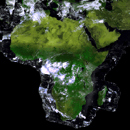
Global land cover maps are provided by ESA WorldCover at 10m resolution and GlobCover at 300m resolution.
-
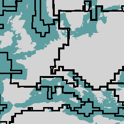
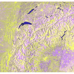
Copernicus CORINE Land Cover
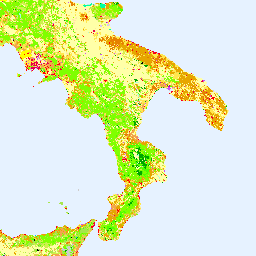
The CORINE (coordination of information on the environment) Land Cover (CLC) inventory was initiated in 1985 to standardize data collection on land in Europe to support environmental policy development. The project is coordinated by the European Environment Agency (EEA) in the frame of the EU … copernicus eea esa eu landcover landuse-landcover -
Copernicus Global Land Cover Layers: CGLS-LC100 Collection 3
The Copernicus Global Land Service (CGLS) is earmarked as a component of the Land service to operate a multi-purpose service component that provides a series of bio-geophysical products on the status and evolution of land surface at global scale. The Dynamic Land Cover map at … copernicus eea esa eu landcover landuse-landcover -
ESA CCI Above-Ground Biomass for 2007, 2010, 2015-2022 (v6.0)
This dataset updated to v6.0 provides estimates of forest above-ground biomass for the years 2007, 2010, 2015, 2016, 2017, 2018, 2019, 2020, 2021, and 2022. These estimates are derived from a combination of Earth observation data, depending on the year, obtained from the Copernicus Sentinel-1 … biomass cci ecosystems esa forest -
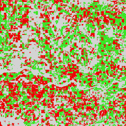
ESA WorldCereal 10 m v100
The European Space Agency (ESA) WorldCereal 10 m 2021 product suite consists of global-scale annual and seasonal crop maps and their related confidence. They were generated as part of the ESA-WorldCereal project. More information on the content of these products and the methodology used to … agriculture copernicus crop esa global landcover -
ESA WorldCereal AEZ v100
The European Space Agency (ESA) WorldCereal classification system aims for product generation within one month after the end of a particular growing season. Due to the dynamic nature of these growing seasons across the globe, a global stratification into Agro-Ecological Zones (AEZ) was performed based … agriculture boundaries crop esa global table -
ESA WorldCereal Active Cropland 10 m v100
The European Space Agency (ESA) WorldCereal Active Cropland 10 m 2021 product suite contains global-scale seasonal active cropland markers. They were generated as part of the ESA-WorldCereal project. The active cropland products indicate whether or not a pixel identified as temporary crops has been actively … agriculture copernicus crop esa global landcover -
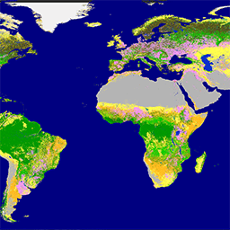
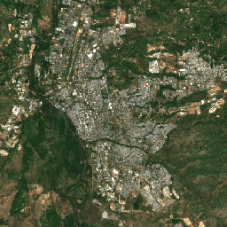
ESA WorldCover 10m v100
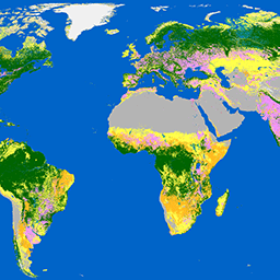
The European Space Agency (ESA) WorldCover 10 m 2020 product provides a global land cover map for 2020 at 10 m resolution based on Sentinel-1 and Sentinel-2 data. The WorldCover product comes with 11 land cover classes and has been generated in the framework of … esa landcover landuse landuse-landcover sentinel1-derived sentinel2-derived -
ESA WorldCover 10m v200

The European Space Agency (ESA) WorldCover 10 m 2021 product provides a global land cover map for 2021 at 10 m resolution based on Sentinel-1 and Sentinel-2 data. The WorldCover product comes with 11 land cover classes and has been generated in the framework of … esa landcover landuse landuse-landcover sentinel1-derived sentinel2-derived -
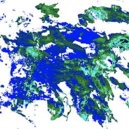
FireCCI51: MODIS Fire_cci Burned Area Pixel Product, Version 5.1
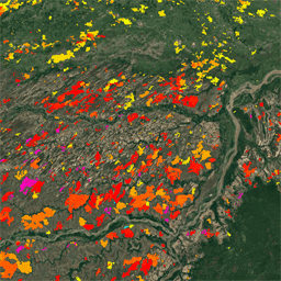
The MODIS Fire_cci Burned Area pixel product version 5.1 (FireCCI51) is a monthly global ~250m spatial resolution dataset containing information on burned area as well as ancillary data. It is based on surface reflectance in the Near Infrared (NIR) band from the MODIS instrument onboard … burn cci climate-change copernicus esa fire -
GlobCover: Global Land Cover Map
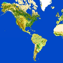
GlobCover 2009 is a global land cover map based on ENVISAT's Medium Resolution Imaging Spectrometer (MERIS) Level 1B data acquired in full resolution mode with a spatial resolution of approximately 300 meters. esa landcover landuse-landcover -
Harmonized Sentinel-2 MSI: MultiSpectral Instrument, Level-1C (TOA)
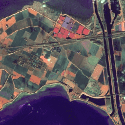
After 2022-01-25, Sentinel-2 scenes with PROCESSING_BASELINE '04.00' or above have their DN (value) range shifted by 1000. The HARMONIZED collection shifts data in newer scenes to be in the same range as in older scenes. Sentinel-2 is a wide-swath, high-resolution, multi-spectral imaging mission supporting Copernicus … copernicus esa eu msi radiance satellite-imagery -
Harmonized Sentinel-2 MSI: MultiSpectral Instrument, Level-2A (SR)
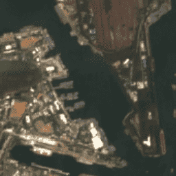
After 2022-01-25, Sentinel-2 scenes with PROCESSING_BASELINE '04.00' or above have their DN (value) range shifted by 1000. The HARMONIZED collection shifts data in newer scenes to be in the same range as in older scenes. Sentinel-2 is a wide-swath, high-resolution, multi-spectral imaging mission supporting Copernicus … copernicus esa eu msi reflectance satellite-imagery -
PROBA-V C1 Top Of Canopy Daily Synthesis 100m
Proba-V is a satellite mission tasked to map land cover and vegetation growth. It was designed to provide continuity for the VGT optical instrument from the SPOT-4 and SPOT-5 missions. The sensor collects data in three VNIR (visible and near-infrared) bands and one SWIR (short-wave … esa multispectral nir proba probav satellite-imagery -
PROBA-V C1 Top Of Canopy Daily Synthesis 333m

Proba-V is a satellite mission tasked to map land cover and vegetation growth. It was designed to provide continuity for the VGT optical instrument from the SPOT-4 and SPOT-5 missions. The sensor collects data in three VNIR (visible and near-infrared) bands and one SWIR (short-wave … esa multispectral nir proba probav satellite-imagery -
Sentinel-1 SAR GRD: C-band Synthetic Aperture Radar Ground Range Detected, log scaling
The Sentinel-1 mission provides data from a dual-polarization C-band Synthetic Aperture Radar (SAR) instrument at 5.405GHz (C band). This collection includes the S1 Ground Range Detected (GRD) scenes, processed using the Sentinel-1 Toolbox to generate a calibrated, ortho-corrected product. The collection is updated daily. New … backscatter copernicus esa eu polarization radar -
Sentinel-2: Cloud Probability
The S2 cloud probability is created with the sentinel2-cloud-detector library (using LightGBM). All bands are upsampled using bilinear interpolation to 10m resolution before the gradient boost base algorithm is applied. The resulting 0..1 floating point probability is scaled to 0..100 and stored as an UINT8. … cloud copernicus esa eu msi radiance -
Sentinel-3 OLCI EFR: Ocean and Land Color Instrument Earth Observation Full Resolution
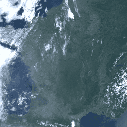
The Ocean and Land Color Instrument (OLCI) Earth Observation Full Resolution (EFR) dataset contains top of atmosphere radiances at 21 spectral bands with center wavelengths ranging between 0.4µm and 1.02µm at spatial resolution of 300m with worldwide coverage every ~2 days. OLCI is one of … copernicus esa eu radiance satellite-imagery sentinel -
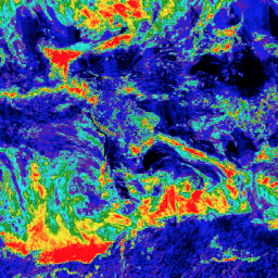
Sentinel-5P NRTI AER AI: Near Real-Time UV Aerosol Index

NRTI/L3_AER_AI This dataset provides near real-time high-resolution imagery of the UV Aerosol Index (UVAI), also called the Absorbing Aerosol Index (AAI). The AAI is based on wavelength-dependent changes in Rayleigh scattering in the UV spectral range for a pair of wavelengths. The difference between observed … aai aerosol air-quality atmosphere copernicus esa -
Sentinel-5P NRTI AER LH: Near Real-Time UV Aerosol Layer Height
NRTI/L3_AER_LH This dataset provides offline high-resolution imagery of the UV Aerosol Index (UVAI), also called the Absorbing Layer Height (ALH). The ALH is very sensitive to cloud contamination. However, aerosols and clouds can be difficult to distinguish, and ALH is computed for all FRESCO effective … aerosol air-quality alh atmosphere copernicus esa -
Sentinel-5P NRTI CLOUD: Near Real-Time Cloud Properties

NRTI/L3_CLOUD This dataset provides near real-time high-resolution imagery of cloud parameters. The TROPOMI/S5P cloud properties retrieval is based on the OCRA and ROCINN algorithms currently being used in the operational GOME and GOME-2 products. OCRA retrieves the cloud fraction using measurements in the UV/VIS spectral … atmosphere cloud copernicus dlr esa eu -
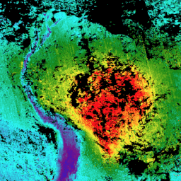
Sentinel-5P NRTI CO: Near Real-Time Carbon Monoxide
NRTI/L3_CO This dataset provides near real-time high-resolution imagery of CO concentrations. Carbon monoxide (CO) is an important atmospheric trace gas for understanding tropospheric chemistry. In certain urban areas, it is a major atmospheric pollutant. Main sources of CO are combustion of fossil fuels, biomass burning, … air-quality atmosphere carbon-monoxide copernicus esa eu -
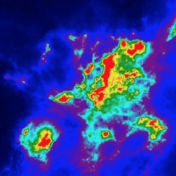
Sentinel-5P NRTI HCHO: Near Real-Time Formaldehyde
NRTI/L3_HCHO This dataset provides near real-time high-resolution imagery of atmospheric formaldehyde (HCHO) concentrations. Formaldehyde is an intermediate gas in almost all oxidation chains of non-methane volatile organic compounds (NMVOC), leading eventually to CO2. Non-Methane Volatile Organic Compounds (NMVOCs) are, together with NOx, CO and CH4, … air-quality atmosphere bira copernicus dlr esa -
Sentinel-5P NRTI NO2: Near Real-Time Nitrogen Dioxide
NRTI/L3_NO2 This dataset provides near real-time high-resolution imagery of NO2 concentrations. Nitrogen oxides (NO2 and NO) are important trace gases in the Earth's atmosphere, present in both the troposphere and the stratosphere. They enter the atmosphere as a result of anthropogenic activities (notably fossil fuel … air-quality atmosphere copernicus esa eu knmi -
Sentinel-5P NRTI O3: Near Real-Time Ozone
NRTI/L3_O3 This dataset provides near-real-time high-resolution imagery of total column ozone concentrations. See also COPERNICUS/S5P/OFFL/L3_O3_TCL for the tropospheric column data. In the stratosphere, the ozone layer shields the biosphere from dangerous solar ultraviolet radiation. In the troposphere, it acts as an efficient cleansing agent, but … air-quality atmosphere copernicus esa eu o3 -
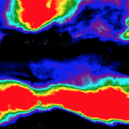
Sentinel-5P NRTI SO2: Near Real-Time Sulfur Dioxide
NRTI/L3_SO2 This dataset provides near real-time high-resolution imagery of atmospheric sulfur dioxide (SO2) concentrations. Sulfur dioxide (SO2) enters the Earth's atmosphere through both natural and anthropogenic processes. It plays a role in chemistry on a local and global scale and its impact ranges from short-term … air-quality atmosphere bira copernicus dlr esa -
Sentinel-5P OFFL AER AI: Offline UV Aerosol Index
OFFL/L3_AER_AI This dataset provides offline high-resolution imagery of the UV Aerosol Index (UVAI), also called the Absorbing Aerosol Index (AAI). The AAI is based on wavelength-dependent changes in Rayleigh scattering in the UV spectral range for a pair of wavelengths. The difference between observed and … aai aerosol air-quality atmosphere copernicus esa -
Sentinel-5P OFFL AER LH: Offline UV Aerosol Layer Height
OFFL/L3_AER_LH This dataset provides offline high-resolution imagery of the UV Aerosol Index (UVAI), also called the Absorbing Layer Height (ALH). The ALH is very sensitive to cloud contamination. However, aerosols and clouds can be difficult to distinguish, and ALH is computed for all FRESCO effective … aerosol air-quality alh atmosphere copernicus esa -
Sentinel-5P OFFL CH4: Offline Methane
OFFL/L3_CH4 This dataset provides offline high-resolution imagery of methane concentrations. Methane (CH4) is, after carbon dioxide (CO2), the most important contributor to the anthropogenically enhanced greenhouse effect. Roughly three-quarters of methane emissions are anthropogenic and as such, it is important to continue the record of … atmosphere climate copernicus esa eu knmi -
Sentinel-5P OFFL CLOUD: Offline Cloud Properties
OFFL/L3_CLOUD This dataset provides offline high-resolution imagery of cloud parameters. The TROPOMI/S5P cloud properties retrieval is based on the OCRA and ROCINN algorithms currently being used in the operational GOME and GOME-2 products. OCRA retrieves the cloud fraction using measurements in the UV/VIS spectral regions … atmosphere cloud copernicus dlr esa eu -
Sentinel-5P OFFL CO: Offline Carbon Monoxide
OFFL/L3_CO This dataset provides offline high-resolution imagery of CO concentrations. Carbon monoxide (CO) is an important atmospheric trace gas for understanding tropospheric chemistry. In certain urban areas, it is a major atmospheric pollutant. Main sources of CO are combustion of fossil fuels, biomass burning, and … air-quality atmosphere carbon-monoxide copernicus esa eu -
Sentinel-5P OFFL HCHO: Offline Formaldehyde

OFFL/L3_HCHO This dataset provides offline high-resolution imagery of atmospheric formaldehyde (HCHO) concentrations. Formaldehyde is an intermediate gas in almost all oxidation chains of non-methane volatile organic compounds (NMVOC), leading eventually to CO2. Non-Methane Volatile Organic Compounds (NMVOCs) are, together with NOx, CO and CH4, among … air-quality atmosphere bira copernicus dlr esa -
Sentinel-5P OFFL NO2: Offline Nitrogen Dioxide
OFFL/L3_NO2 This dataset provides offline high-resolution imagery of NO2 concentrations. Nitrogen oxides (NO2 and NO) are important trace gases in the Earth's atmosphere, present in both the troposphere and the stratosphere. They enter the atmosphere as a result of anthropogenic activities (notably fossil fuel combustion … air-quality atmosphere copernicus esa eu knmi -
Sentinel-5P OFFL O3 TCL: Offline Tropospheric Ozone

OFFL/L3_O3_TCL This dataset provides offline tropospheric high-resolution imagery of ozone concentrations between 20N and 20S. See also COPERNICUS/S5P/OFFL/L3_O3 and COPERNICUS/S5P/NRTI/L3_O3 for the total column data. In the stratosphere, the ozone layer shields the biosphere from dangerous solar ultraviolet radiation. In the troposphere, it acts as … air-quality atmosphere copernicus esa eu o3 -
Sentinel-5P OFFL O3: Offline Ozone
OFFL/L3_O3 This dataset provides offline high-resolution imagery of total column ozone concentrations. See also COPERNICUS/S5P/OFFL/L3_O3_TCL for the tropospheric column data. In the stratosphere, the ozone layer shields the biosphere from dangerous solar ultraviolet radiation. In the troposphere, it acts as an efficient cleansing agent, but … air-quality atmosphere copernicus esa eu o3 -
Sentinel-5P OFFL SO2: Offline Sulfur Dioxide
OFFL/L3_SO2 This dataset provides offline high-resolution imagery of atmospheric sulfur dioxide (SO2) concentrations. Sulfur dioxide (SO2) enters the Earth's atmosphere through both natural and anthropogenic processes. It plays a role in chemistry on a local and global scale and its impact ranges from short-term pollution … air-quality atmosphere bira copernicus dlr esa