Page Summary
-
The ESA WorldCereal Active Cropland 10 m 2021 dataset provides global-scale seasonal active cropland markers.
-
This dataset identifies if a pixel designated as temporary crops was actively cultivated within a specific growing season.
-
The active marker is determined by detecting a full crop growth cycle using a growing season detection algorithm applied to Sentinel-2 derived enhanced vegetation index (EVI).
-
The collection includes images for various agro-ecological zones and specific crop seasons like winter cereals, spring cereals, and maize.
-
Each product in the collection has a binary classification band indicating inactive (0) or active (100) cropland.
- Dataset Availability
- 2020-01-01T00:00:00Z–2021-12-31T23:59:59Z
- Dataset Producer
- ESA WorldCereal Consortium
- Tags
Description
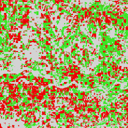
The European Space Agency (ESA) WorldCereal Active Cropland 10 m 2021 product suite contains global-scale seasonal active cropland markers. They were generated as part of the ESA-WorldCereal project. The active cropland products indicate whether or not a pixel identified as temporary crops has been actively cultivated during a specific growing season. In order for a pixel to be labeled as “active” during a particular growing season, a full crop growth cycle (sowing, growing, senescence and harvesting) needs to take place within the designated time period. Note that this active marker is not crop-type specific. Any crop grown (slightly) outside the predefined growing seasons will not be flagged as active cropland in any of the seasons covered by the WorldCereal system. The active marker results from running a growing season detection algorithm [1] on the Sentinel-2 derived enhanced vegetation index (EVI). More information on the methodology used to generate these products is described in [2].
This collection contains up to 106 agro-ecological zone (AEZ) images per crop season, where each AEZ has its own seasonality. The seasons for which the active cropland marker is available are described in the list below and were developed in [3] as part of the project.
WorldCereal seasons description:
- tc-wintercereals: the main cereals season defined in an AEZ
- tc-springcereals: optional springcereals season, only defined in certain AEZ
- tc-maize-main: the main maize season defined in an AEZ
- tc-maize-second: optional second maize season, only defined in certain AEZ
Each product (image) has a binary classification band where value 0 corresponds to inactive cropland and value 100 corresponds to active cropland.
The collection should be filtered using one or more of the following image properties:
- aez_id, holding the ID of the AEZ to which the image belongs
- season, describing the season for which the image is valid.
References:
- [1] Bolton, D. K., Gray, J. M., Melaas, E. K., Moon, M., Eklundh, L., and Friedl, M. A.: Continental-scale land surface phenology from harmonized Landsat 8 and Sentinel-2 imagery, Remote Sens. Environ., 240, 111685, https://doi.org/10.1016/j.rse.2020.111685, 2020.
- [2] WorldCereal methodology and products paper
- [3] WorldCereal global seasonality paper
WorldCereal datasets:
- Version 100 for year 2021
Bands
Bands
Pixel size: 10 meters (all bands)
| Name | Min | Max | Pixel Size | Description |
|---|---|---|---|---|
classification |
0 | 100 | 10 meters | Classification: 0 or 100 |
Image Properties
Image Properties
| Name | Type | Description |
|---|---|---|
| aez_id | INT | ID of the agro-ecological zone (AEZ) to which the product belongs. |
| product | STRING | WorldCereal product name. |
| season | STRING | Season for which the product is valid. |
Terms of Use
Terms of Use
Citations
Van Tricht, K., Degerickx, J., Gilliams, S., Zanaga, D., Battude, M., Grosu, A., Brombacher, J., Lesiv, M., Bayas, J. C. L., Karanam, S., Fritz, S., Becker-Reshef, I., Franch, B., Mollà-Bononad, B., Boogaard, H., Pratihast, A. K., and Szantoi, Z.: WorldCereal: a dynamic open-source system for global-scale, seasonal, and reproducible crop and irrigation mapping, Earth Syst. Sci. Data Discuss. [preprint], doi:10.5194/essd-2023-184, in review, 2023.,
DOIs
Explore with Earth Engine
Code Editor (JavaScript)
var dataset = ee.ImageCollection('ESA/WorldCereal/2021/MARKERS/v100')

// Filter on AEZ
var aez_46173 = dataset.filter('aez_id == 46173');

// Get the active cropland marker for the different seasons
var activemarker_summerseason = aez_46173.filter('season == "tc-maize-main"');
var activemarker_winterseason = aez_46173.filter('season == "tc-wintercereals"');

// Visualization specifics: red is inactive, green is active cropland
var visualization = {
  bands: ['classification'],
  max: 100,
  palette: ['eb0000', '37e622']
};

// Show active cropland in two major growing seasons in US.
Map.addLayer(activemarker_summerseason, visualization, 'Active cropland tc-maize-main');
Map.addLayer(activemarker_winterseason, visualization, 'Active cropland tc-wintercereals');

Map.setCenter(-98.987, 38.0454, 11)