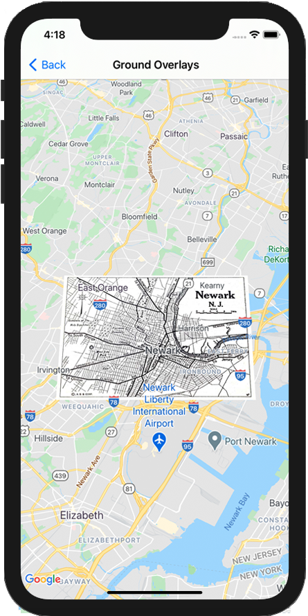
區域疊加層是指地圖上與經緯度座標連動的疊加層,因此會隨著您拖曳或縮放地圖而移動。

簡介
區域疊加層是指固定於地圖上的圖片。不同於標記,區域疊加層顯示方向的依據是實際地表而非裝置螢幕,因此旋轉、傾斜或縮放地圖時,圖片的方向也會隨之改變。
如要新增地面疊加層,請建立 GMSGroundOverlay 物件,定義圖示和邊界。如果未指定其中一項,地圖上就不會顯示區域疊加層。您可以視需要指定額外設定,影響地圖上圖片的位置。定義必要的選項後,請設定這個物件的 map 屬性,即可新增疊加層。
新增疊加層
- 將新的
GMSGroundOverlay物件執行個體化 - 將
icon屬性設為UIImage的例項。 - 將
bounds屬性設為GMSCoordinateBounds的例項。邊界代表圖片的西南角和東北角。 - 視需要設定選用屬性,例如
bearing和zoomLevel。 - 設定
map屬性,地圖上就會顯示圖片。
以下範例說明如何將區域疊加層加到現有的 GMSMapView 物件。
Swift
let southWest = CLLocationCoordinate2D(latitude: 40.712216, longitude: -74.22655)
let northEast = CLLocationCoordinate2D(latitude: 40.773941, longitude: -74.12544)
let overlayBounds = GMSCoordinateBounds(coordinate: southWest, coordinate: northEast)

// Image from http://www.lib.utexas.edu/maps/historical/newark_nj_1922.jpg
let icon = UIImage(named: "newark_nj_1922")

let overlay = GMSGroundOverlay(bounds: overlayBounds, icon: icon)
overlay.bearing = 0
overlay.map = mapView
Objective-C
CLLocationCoordinate2D southWest = CLLocationCoordinate2DMake(40.712216,-74.22655);
CLLocationCoordinate2D northEast = CLLocationCoordinate2DMake(40.773941,-74.12544);
GMSCoordinateBounds *overlayBounds = [[GMSCoordinateBounds alloc] initWithCoordinate:southWest
                                                                        coordinate:northEast];

// Image from http://www.lib.utexas.edu/maps/historical/newark_nj_1922.jpg
UIImage *icon = [UIImage imageNamed:@"newark_nj_1922"];
GMSGroundOverlay *overlay = [GMSGroundOverlay groundOverlayWithBounds:overlayBounds icon:icon];
overlay.bearing = 0;
overlay.map = mapView;
移除疊加層
如要從地圖中移除區域疊加層,請將 GMSGroundOverlay 的 map 屬性設為 nil。或者,您也可以呼叫 GMSMapView clear 方法,移除所有疊加層 (包括目前地圖上的區域疊加層)。
Swift
mapView.clear()
Objective-C
[mapView clear];
如果您在區域疊加層加到地圖中之後,想要予以修改,請務必保留 GMSGroundOverlay 物件,這樣稍後您只要變更這個物件,就可以修改地面疊加層。
Swift
let overlay = GMSGroundOverlay(bounds: overlayBounds, icon: icon)
overlay.bearing = 0
overlay.map = mapView

// ...

overlay.isTappable = true
Objective-C
GMSGroundOverlay *overlay = [GMSGroundOverlay groundOverlayWithBounds:overlayBounds icon:icon];
overlay.bearing = 0;
overlay.map = mapView;

// ...
overlay.tappable = YES;
事件
您可以監聽地圖上發生的事件,例如使用者輕觸疊加層。如要監聽事件,請導入 GMSMapViewDelegate 通訊協定。請參閱事件指南和 GMSMapViewDelegate 中的方法清單。
