São sobreposições no mapa vinculadas a coordenadas de latitude/longitude. Portanto, elas se movimentam quando você arrasta o mapa ou aplica zoom a ele.
Introdução
Uma sobreposição de solo é uma imagem fixa em um mapa. Diferentemente dos marcadores, as sobreposições de solo são orientadas contra a superfície da Terra e não da tela. Portanto, girar, inclinar ou aplicar zoom no mapa muda a orientação da imagem.
Para adicionar uma sobreposição de solo, crie um objeto GMSGroundOverlay que defina um ícone e limites. Se você não especificar nenhum dos dois, a sobreposição de solo não vai aparecer no mapa. Também é possível especificar configurações adicionais que afetam o posicionamento da imagem no mapa.
Depois de definir as opções necessárias, defina a propriedade map desse objeto para adicionar a sobreposição.
Adicionar uma sobreposição
Instancie um novo objeto GMSGroundOverlay.
Defina a propriedade icon como uma instância de UIImage.
Defina a propriedade bounds como uma instância de GMSCoordinateBounds. Os limites representam os cantos sudoeste e nordeste da imagem.
Defina propriedades opcionais, como bearing e zoomLevel, conforme necessário.
Defina a propriedade map. A imagem vai aparecer no mapa.
O exemplo abaixo demonstra como incluir uma sobreposição de solo em um objeto GMSMapView.
Swift
letsouthWest=CLLocationCoordinate2D(latitude:40.712216,longitude:-74.22655)letnorthEast=CLLocationCoordinate2D(latitude:40.773941,longitude:-74.12544)letoverlayBounds=GMSCoordinateBounds(coordinate:southWest,coordinate:northEast)// Image from http://www.lib.utexas.edu/maps/historical/newark_nj_1922.jpgleticon=UIImage(named:"newark_nj_1922")letoverlay=GMSGroundOverlay(bounds:overlayBounds,icon:icon)overlay.bearing=0overlay.map=mapView
Objective-C
CLLocationCoordinate2DsouthWest=CLLocationCoordinate2DMake(40.712216,-74.22655);CLLocationCoordinate2DnorthEast=CLLocationCoordinate2DMake(40.773941,-74.12544);GMSCoordinateBounds*overlayBounds=[[GMSCoordinateBoundsalloc]initWithCoordinate:southWestcoordinate:northEast];// Image from http://www.lib.utexas.edu/maps/historical/newark_nj_1922.jpgUIImage*icon=[UIImageimageNamed:@"newark_nj_1922"];GMSGroundOverlay*overlay=[GMSGroundOverlaygroundOverlayWithBounds:overlayBoundsicon:icon];overlay.bearing=0;overlay.map=mapView;
Remover uma sobreposição
Para remover uma sobreposição de solo do mapa, defina a propriedade map do GMSGroundOverlay como nil. Como alternativa, você pode remover todas as sobreposições (incluindo as de solo atualmente no mapa) chamando o método GMSMapViewclear.
Swift
mapView.clear()
Objective-C
[mapViewclear];
Para mudar uma sobreposição de solo depois de adicioná-la ao mapa, mantenha o objeto GMSGroundOverlay. Você pode modificar a sobreposição de solo mais tarde fazendo alterações nesse objeto.
É possível detectar eventos que ocorrem no mapa, como quando um usuário toca em uma
sobreposição. Para detectar eventos, é necessário implementar o protocolo
GMSMapViewDelegate. Consulte o guia de eventos e a lista de métodos em GMSMapViewDelegate.
[[["Fácil de entender","easyToUnderstand","thumb-up"],["Meu problema foi resolvido","solvedMyProblem","thumb-up"],["Outro","otherUp","thumb-up"]],[["Não contém as informações de que eu preciso","missingTheInformationINeed","thumb-down"],["Muito complicado / etapas demais","tooComplicatedTooManySteps","thumb-down"],["Desatualizado","outOfDate","thumb-down"],["Problema na tradução","translationIssue","thumb-down"],["Problema com as amostras / o código","samplesCodeIssue","thumb-down"],["Outro","otherDown","thumb-down"]],["Última atualização 2025-09-05 UTC."],[[["\u003cp\u003eGround overlays are images fixed to a map, oriented to the Earth's surface, and change orientation with map interactions.\u003c/p\u003e\n"],["\u003cp\u003eTo add a ground overlay, create a \u003ccode\u003eGMSGroundOverlay\u003c/code\u003e object, define its icon, bounds, and optional settings, then set its \u003ccode\u003emap\u003c/code\u003e property.\u003c/p\u003e\n"],["\u003cp\u003eGround overlays can be removed by setting the \u003ccode\u003emap\u003c/code\u003e property to \u003ccode\u003enil\u003c/code\u003e or using the \u003ccode\u003eclear\u003c/code\u003e method on the \u003ccode\u003eGMSMapView\u003c/code\u003e.\u003c/p\u003e\n"],["\u003cp\u003eModifications to existing ground overlays can be made by accessing and updating the \u003ccode\u003eGMSGroundOverlay\u003c/code\u003e object directly.\u003c/p\u003e\n"],["\u003cp\u003eImplement the \u003ccode\u003eGMSMapViewDelegate\u003c/code\u003e protocol to listen to events like user taps on the overlay.\u003c/p\u003e\n"]]],["Ground overlays, images fixed to a map using latitude/longitude, are added by creating a `GMSGroundOverlay` object. This requires setting both the `icon` (an image) and `bounds` (southwest/northeast coordinates). Optionally, set properties like `bearing` and `zoomLevel`. To display, assign the object's `map` property. Overlays are removed by setting `map` to `nil` or using the `clear` method. Modifications require retaining the `GMSGroundOverlay` object and to listen for events, you must implement `GMSMapViewDelegate`.\n"],null,["Select platform: [Android](/maps/documentation/android-sdk/groundoverlay \"View this page for the Android platform docs.\") [iOS](/maps/documentation/ios-sdk/overlays \"View this page for the iOS platform docs.\") [JavaScript](/maps/documentation/javascript/groundoverlays \"View this page for the JavaScript platform docs.\")\n\n\u003cbr /\u003e\n\nGround overlays are overlays on the map that are tied to latitude/longitude\ncoordinates, so they move when you drag or zoom the map.\n\nIntroduction\n\nA ground overlay is an image that is fixed to a map. Unlike\n[markers](/maps/documentation/ios-sdk/marker), ground overlays are oriented against the Earth's surface\nrather than the screen, so rotating, tilting or zooming the map will change\nthe orientation of the image.\n\nTo add a ground overlay, create a\n[`GMSGroundOverlay`](/maps/documentation/ios-sdk/reference/objc/Classes/GMSGroundOverlay)\nobject that defines both an icon and a bounds. Failing to specify either will\ncause the ground overlay to not appear on the map. You can optionally specify\nadditional settings that will affect the positioning of the image on the map.\nOnce you've defined the necessary options, set this object's `map` property to\nadd the overlay.\n\nAdding an overlay\n\n1. Instantiate a new `GMSGroundOverlay` object\n2. Set the `icon` property to an instance of `UIImage`.\n3. Set the `bounds` property to an instance of `GMSCoordinateBounds`. The bounds represent the south west, and north east corners of the image.\n4. Set optional properties, such as `bearing` and `zoomLevel`, as desired.\n5. Set the `map` property - the image appears on the map.\n\nThe below example demonstrates how to add a ground overlay to an existing\n`GMSMapView` object.\n\n\nSwift \n\n```swift\n
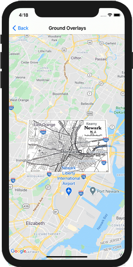
let southWest = CLLocationCoordinate2D(latitude: 40.712216, longitude: -74.22655)\nlet northEast = CLLocationCoordinate2D(latitude: 40.773941, longitude: -74.12544)\nlet overlayBounds = GMSCoordinateBounds(coordinate: southWest, coordinate: northEast)\n\n// Image from http://www.lib.utexas.edu/maps/historical/newark_nj_1922.jpg\nlet icon = UIImage(named: \"newark_nj_1922\")\n\nlet overlay = GMSGroundOverlay(bounds: overlayBounds, icon: icon)\noverlay.bearing = 0\noverlay.map = mapView\n \n```\n\nObjective-C \n\n```objective-c\nCLLocationCoordinate2D southWest = CLLocationCoordinate2DMake(40.712216,-74.22655);\nCLLocationCoordinate2D northEast = CLLocationCoordinate2DMake(40.773941,-74.12544);\nGMSCoordinateBounds *overlayBounds = [[GMSCoordinateBounds alloc] initWithCoordinate:southWest\n coordinate:northEast];\n\n// Image from http://www.lib.utexas.edu/maps/historical/newark_nj_1922.jpg\nUIImage *icon = [UIImage imageNamed:@\"newark_nj_1922\"];\nGMSGroundOverlay *overlay = [GMSGroundOverlay groundOverlayWithBounds:overlayBounds icon:icon];\noverlay.bearing = 0;\noverlay.map = mapView;\n \n```\n\n\u003cbr /\u003e\n\nRemoving an overlay\n\nYou can remove a ground overlay from the map by setting your\n`GMSGroundOverlay`'s `map` property to `nil`. Alternately, you can remove all\nof the overlays (including ground overlays currently on the map by calling the\n`GMSMapView` `clear` method.\n\n\nSwift \n\n```swift\nmapView.clear()\n \n```\n\nObjective-C \n\n```objective-c\n[mapView clear];\n \n```\n\n\u003cbr /\u003e\n\nIf you wish to make modifications to a ground overlay after you've added it to\nthe map, ensure that you keep hold of the `GMSGroundOverlay` object. You can\nmodify the ground overlay later by making changes to this object.\n\n\nSwift \n\n```swift\nlet overlay = GMSGroundOverlay(bounds: overlayBounds, icon: icon)\noverlay.bearing = 0\noverlay.map = mapView\n\n// ...\n\noverlay.isTappable = true\n \n```\n\nObjective-C \n\n```objective-c\nGMSGroundOverlay *overlay = [GMSGroundOverlay groundOverlayWithBounds:overlayBounds icon:icon];\noverlay.bearing = 0;\noverlay.map = mapView;\n\n// ...\noverlay.tappable = YES;\n \n```\n\n\u003cbr /\u003e\n\nEvents\n\nYou can listen to events that occur on the map, such as when a user taps an\noverlay. To listen to events, you must implement the\n[`GMSMapViewDelegate`](/maps/documentation/ios-sdk/reference/objc/Protocols/GMSMapViewDelegate) protocol. See the\n[guide to events](/maps/documentation/ios-sdk/events) and the list of methods on the\n[`GMSMapViewDelegate`](/maps/documentation/ios-sdk/reference/objc/Protocols/GMSMapViewDelegate)."]]