
Nakładki na mapie są powiązane z współrzędnymi geograficznymi, dlatego poruszają się, gdy przeciągasz mapę lub ją powiększasz.
Wprowadzenie
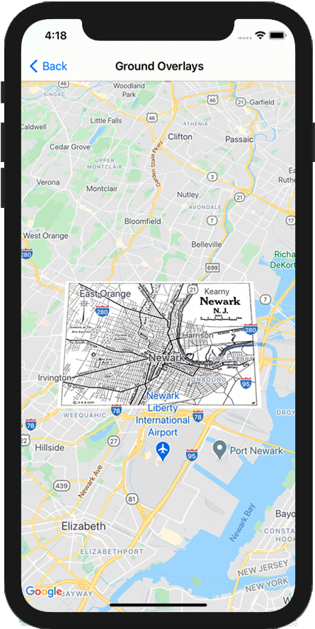
Nakładka naziemna to obraz przymocowany do mapy. W odróżnieniu od znaczników nakładki na mapie są zorientowane względem powierzchni Ziemi, a nie ekranu, więc obracanie, przechylanie i powiększanie mapy powoduje zmianę orientacji obrazu.
Aby dodać nakładkę na ziemię, utwórz obiekt GMSGroundOverlay, który definiuje ikonę i granice. Jeśli nie określisz żadnej z tych wartości, nakładka terenu nie będzie widoczna na mapie. Opcjonalnie możesz określić dodatkowe ustawienia, które wpłyną na pozycjonowanie obrazu na mapie.
Po zdefiniowaniu niezbędnych opcji ustaw właściwość map tego obiektu, aby dodać nakładkę.
Dodawanie nakładki
- Utwórz instancję nowego obiektu
GMSGroundOverlay. - Ustaw właściwość
iconna instancjęUIImage. - Ustaw właściwość
boundsna instancjęGMSCoordinateBounds. Granice te odpowiadają narożnikom południowo-zachodniemu i północno-wschodniemu obrazu. - W razie potrzeby ustaw właściwości opcjonalne, takie jak
bearingizoomLevel. - Ustaw właściwość
map– obraz pojawi się na mapie.
W tym przykładzie pokazujemy, jak dodać nakładkę na ziemię do istniejącego obiektu GMSMapView.
Swift
let southWest = CLLocationCoordinate2D(latitude: 40.712216, longitude: -74.22655)
let northEast = CLLocationCoordinate2D(latitude: 40.773941, longitude: -74.12544)
let overlayBounds = GMSCoordinateBounds(coordinate: southWest, coordinate: northEast)

// Image from http://www.lib.utexas.edu/maps/historical/newark_nj_1922.jpg
let icon = UIImage(named: "newark_nj_1922")

let overlay = GMSGroundOverlay(bounds: overlayBounds, icon: icon)
overlay.bearing = 0
overlay.map = mapView
Objective-C
CLLocationCoordinate2D southWest = CLLocationCoordinate2DMake(40.712216,-74.22655);
CLLocationCoordinate2D northEast = CLLocationCoordinate2DMake(40.773941,-74.12544);
GMSCoordinateBounds *overlayBounds = [[GMSCoordinateBounds alloc] initWithCoordinate:southWest
                                                                        coordinate:northEast];

// Image from http://www.lib.utexas.edu/maps/historical/newark_nj_1922.jpg
UIImage *icon = [UIImage imageNamed:@"newark_nj_1922"];
GMSGroundOverlay *overlay = [GMSGroundOverlay groundOverlayWithBounds:overlayBounds icon:icon];
overlay.bearing = 0;
overlay.map = mapView;
Usuwanie nakładki
Możesz usunąć nakładkę terenu z mapy, ustawiając w elementach GMSGroundOverlay map wartość nil. Możesz też usunąć wszystkie nakładki (w tym nakładki naziemne widoczne na mapie), wywołując metodę GMSMapView clear.
Swift
mapView.clear()
Objective-C
[mapView clear];
Jeśli chcesz wprowadzić zmiany w nakładce na grunt po dodaniu jej do mapy, pamiętaj, aby nie zwalniać obiektu GMSGroundOverlay. Możesz zmodyfikować nakładkę na ziemię, wprowadzając zmiany w tym obiekcie.
Swift
let overlay = GMSGroundOverlay(bounds: overlayBounds, icon: icon)
overlay.bearing = 0
overlay.map = mapView

// ...

overlay.isTappable = true
Objective-C
GMSGroundOverlay *overlay = [GMSGroundOverlay groundOverlayWithBounds:overlayBounds icon:icon];
overlay.bearing = 0;
overlay.map = mapView;

// ...
overlay.tappable = YES;
Wydarzenia
Możesz nasłuchiwać zdarzeń, które występują na mapie, np. gdy użytkownik kliknie nakładkę. Aby nasłuchiwać zdarzeń, musisz zaimplementować protokół GMSMapViewDelegate. Zapoznaj się z przewodnikiem po zdarzeniach i listą metod na stronie GMSMapViewDelegate.