Boden-Overlays sind Overlays auf der Karte, die an Breiten- und Längengrad gebunden sind, sodass sie sich beim Ziehen und Zoomen der Karte mitbewegen.
Einführung
Ein Boden-Overlay ist ein Bild, das auf einer Karte fixiert ist. Im Unterschied zu Markierungen sind Boden-Overlays an der Erdoberfläche und nicht am Bildschirm ausgerichtet. Deshalb wirkt sich das Drehen, Neigen oder Zoomen der Karte auch auf die Ausrichtung des Overlay-Bildes aus.
Um ein Boden-Overlay hinzuzufügen, erstellen Sie ein GMSGroundOverlay-Objekt, das sowohl ein Symbol als auch Grenzen definiert. Wenn Sie keine der beiden Angaben machen, wird das Boden-Overlay nicht auf der Karte angezeigt. Sie können außerdem zusätzliche Einstellungen angeben, die die Positionierung des Bilds auf der Karte beeinflussen.
Nachdem Sie die erforderlichen Optionen definiert haben, legen Sie die map-Eigenschaft dieses Objekts fest, um das Overlay hinzuzufügen.
Overlay hinzufügen
Instanziieren Sie ein neues GMSGroundOverlay-Objekt.
Legen Sie die icon-Eigenschaft auf eine Instanz von UIImage fest.
Legen Sie die bounds-Eigenschaft auf eine Instanz von GMSCoordinateBounds fest. Die Grenzen stellen die Südwest- und Nordostecken des Bildes dar.
Legen Sie bei Bedarf optionale Eigenschaften wie bearing und zoomLevel fest.
Legen Sie die map-Eigenschaft fest. Das Bild wird auf der Karte angezeigt.
Im folgenden Beispiel sehen Sie, wie ein Boden-Overlay einem vorhandenen GMSMapView-Objekt hinzugefügt wird:
Swift
letsouthWest=CLLocationCoordinate2D(latitude:40.712216,longitude:-74.22655)letnorthEast=CLLocationCoordinate2D(latitude:40.773941,longitude:-74.12544)letoverlayBounds=GMSCoordinateBounds(coordinate:southWest,coordinate:northEast)// Image from http://www.lib.utexas.edu/maps/historical/newark_nj_1922.jpgleticon=UIImage(named:"newark_nj_1922")letoverlay=GMSGroundOverlay(bounds:overlayBounds,icon:icon)overlay.bearing=0overlay.map=mapView
Objective-C
CLLocationCoordinate2DsouthWest=CLLocationCoordinate2DMake(40.712216,-74.22655);CLLocationCoordinate2DnorthEast=CLLocationCoordinate2DMake(40.773941,-74.12544);GMSCoordinateBounds*overlayBounds=[[GMSCoordinateBoundsalloc]initWithCoordinate:southWestcoordinate:northEast];// Image from http://www.lib.utexas.edu/maps/historical/newark_nj_1922.jpgUIImage*icon=[UIImageimageNamed:@"newark_nj_1922"];GMSGroundOverlay*overlay=[GMSGroundOverlaygroundOverlayWithBounds:overlayBoundsicon:icon];overlay.bearing=0;overlay.map=mapView;
Overlay entfernen
Sie können ein Boden-Overlay von der Karte entfernen, indem Sie die map-Eigenschaft von GMSGroundOverlay auf nil setzen. Alternativ können Sie alle Overlays (einschließlich der Boden-Overlays, die sich derzeit auf der Karte befinden) entfernen, indem Sie die Methode GMSMapViewclear aufrufen.
Swift
mapView.clear()
Objective-C
[mapViewclear];
Wenn Sie ein Boden-Overlay ändern möchten, nachdem Sie es der Karte hinzugefügt haben, muss das Objekt GMSGroundOverlay beibehalten werden. Sie können das Boden-Overlay später über dieses Objekt ändern.
Sie können auf Ereignisse warten, die auf der Karte auftreten, z. B. wenn ein Nutzer auf ein Overlay tippt. Damit auf Ereignisse gewartet werden kann, müssen Sie das Protokoll GMSMapViewDelegate implementieren. Weitere Informationen finden Sie im Leitfaden zu Ereignissen und in der Liste der Methoden für GMSMapViewDelegate.
[[["Leicht verständlich","easyToUnderstand","thumb-up"],["Mein Problem wurde gelöst","solvedMyProblem","thumb-up"],["Sonstiges","otherUp","thumb-up"]],[["Benötigte Informationen nicht gefunden","missingTheInformationINeed","thumb-down"],["Zu umständlich/zu viele Schritte","tooComplicatedTooManySteps","thumb-down"],["Nicht mehr aktuell","outOfDate","thumb-down"],["Problem mit der Übersetzung","translationIssue","thumb-down"],["Problem mit Beispielen/Code","samplesCodeIssue","thumb-down"],["Sonstiges","otherDown","thumb-down"]],["Zuletzt aktualisiert: 2025-09-05 (UTC)."],[[["\u003cp\u003eGround overlays are images fixed to a map, oriented to the Earth's surface, and change orientation with map interactions.\u003c/p\u003e\n"],["\u003cp\u003eTo add a ground overlay, create a \u003ccode\u003eGMSGroundOverlay\u003c/code\u003e object, define its icon, bounds, and optional settings, then set its \u003ccode\u003emap\u003c/code\u003e property.\u003c/p\u003e\n"],["\u003cp\u003eGround overlays can be removed by setting the \u003ccode\u003emap\u003c/code\u003e property to \u003ccode\u003enil\u003c/code\u003e or using the \u003ccode\u003eclear\u003c/code\u003e method on the \u003ccode\u003eGMSMapView\u003c/code\u003e.\u003c/p\u003e\n"],["\u003cp\u003eModifications to existing ground overlays can be made by accessing and updating the \u003ccode\u003eGMSGroundOverlay\u003c/code\u003e object directly.\u003c/p\u003e\n"],["\u003cp\u003eImplement the \u003ccode\u003eGMSMapViewDelegate\u003c/code\u003e protocol to listen to events like user taps on the overlay.\u003c/p\u003e\n"]]],["Ground overlays, images fixed to a map using latitude/longitude, are added by creating a `GMSGroundOverlay` object. This requires setting both the `icon` (an image) and `bounds` (southwest/northeast coordinates). Optionally, set properties like `bearing` and `zoomLevel`. To display, assign the object's `map` property. Overlays are removed by setting `map` to `nil` or using the `clear` method. Modifications require retaining the `GMSGroundOverlay` object and to listen for events, you must implement `GMSMapViewDelegate`.\n"],null,["Select platform: [Android](/maps/documentation/android-sdk/groundoverlay \"View this page for the Android platform docs.\") [iOS](/maps/documentation/ios-sdk/overlays \"View this page for the iOS platform docs.\") [JavaScript](/maps/documentation/javascript/groundoverlays \"View this page for the JavaScript platform docs.\")\n\n\u003cbr /\u003e\n\nGround overlays are overlays on the map that are tied to latitude/longitude\ncoordinates, so they move when you drag or zoom the map.\n\nIntroduction\n\nA ground overlay is an image that is fixed to a map. Unlike\n[markers](/maps/documentation/ios-sdk/marker), ground overlays are oriented against the Earth's surface\nrather than the screen, so rotating, tilting or zooming the map will change\nthe orientation of the image.\n\nTo add a ground overlay, create a\n[`GMSGroundOverlay`](/maps/documentation/ios-sdk/reference/objc/Classes/GMSGroundOverlay)\nobject that defines both an icon and a bounds. Failing to specify either will\ncause the ground overlay to not appear on the map. You can optionally specify\nadditional settings that will affect the positioning of the image on the map.\nOnce you've defined the necessary options, set this object's `map` property to\nadd the overlay.\n\nAdding an overlay\n\n1. Instantiate a new `GMSGroundOverlay` object\n2. Set the `icon` property to an instance of `UIImage`.\n3. Set the `bounds` property to an instance of `GMSCoordinateBounds`. The bounds represent the south west, and north east corners of the image.\n4. Set optional properties, such as `bearing` and `zoomLevel`, as desired.\n5. Set the `map` property - the image appears on the map.\n\nThe below example demonstrates how to add a ground overlay to an existing\n`GMSMapView` object.\n\n\nSwift \n\n```swift\n
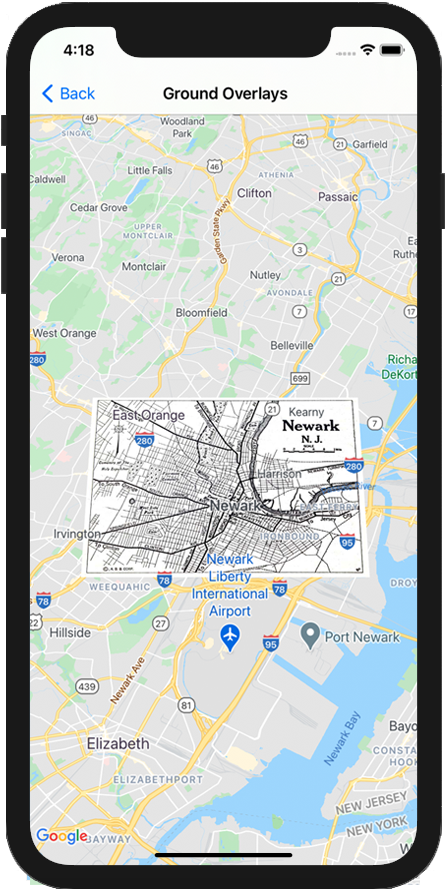
let southWest = CLLocationCoordinate2D(latitude: 40.712216, longitude: -74.22655)\nlet northEast = CLLocationCoordinate2D(latitude: 40.773941, longitude: -74.12544)\nlet overlayBounds = GMSCoordinateBounds(coordinate: southWest, coordinate: northEast)\n\n// Image from http://www.lib.utexas.edu/maps/historical/newark_nj_1922.jpg\nlet icon = UIImage(named: \"newark_nj_1922\")\n\nlet overlay = GMSGroundOverlay(bounds: overlayBounds, icon: icon)\noverlay.bearing = 0\noverlay.map = mapView\n \n```\n\nObjective-C \n\n```objective-c\nCLLocationCoordinate2D southWest = CLLocationCoordinate2DMake(40.712216,-74.22655);\nCLLocationCoordinate2D northEast = CLLocationCoordinate2DMake(40.773941,-74.12544);\nGMSCoordinateBounds *overlayBounds = [[GMSCoordinateBounds alloc] initWithCoordinate:southWest\n coordinate:northEast];\n\n// Image from http://www.lib.utexas.edu/maps/historical/newark_nj_1922.jpg\nUIImage *icon = [UIImage imageNamed:@\"newark_nj_1922\"];\nGMSGroundOverlay *overlay = [GMSGroundOverlay groundOverlayWithBounds:overlayBounds icon:icon];\noverlay.bearing = 0;\noverlay.map = mapView;\n \n```\n\n\u003cbr /\u003e\n\nRemoving an overlay\n\nYou can remove a ground overlay from the map by setting your\n`GMSGroundOverlay`'s `map` property to `nil`. Alternately, you can remove all\nof the overlays (including ground overlays currently on the map by calling the\n`GMSMapView` `clear` method.\n\n\nSwift \n\n```swift\nmapView.clear()\n \n```\n\nObjective-C \n\n```objective-c\n[mapView clear];\n \n```\n\n\u003cbr /\u003e\n\nIf you wish to make modifications to a ground overlay after you've added it to\nthe map, ensure that you keep hold of the `GMSGroundOverlay` object. You can\nmodify the ground overlay later by making changes to this object.\n\n\nSwift \n\n```swift\nlet overlay = GMSGroundOverlay(bounds: overlayBounds, icon: icon)\noverlay.bearing = 0\noverlay.map = mapView\n\n// ...\n\noverlay.isTappable = true\n \n```\n\nObjective-C \n\n```objective-c\nGMSGroundOverlay *overlay = [GMSGroundOverlay groundOverlayWithBounds:overlayBounds icon:icon];\noverlay.bearing = 0;\noverlay.map = mapView;\n\n// ...\noverlay.tappable = YES;\n \n```\n\n\u003cbr /\u003e\n\nEvents\n\nYou can listen to events that occur on the map, such as when a user taps an\noverlay. To listen to events, you must implement the\n[`GMSMapViewDelegate`](/maps/documentation/ios-sdk/reference/objc/Protocols/GMSMapViewDelegate) protocol. See the\n[guide to events](/maps/documentation/ios-sdk/events) and the list of methods on the\n[`GMSMapViewDelegate`](/maps/documentation/ios-sdk/reference/objc/Protocols/GMSMapViewDelegate)."]]