
تكون التراكبات الأرضية عبارة عن تراكبات على الخريطة مرتبطة بإحداثيات خطوط الطول والعرض، وبالتالي تتحرك عند سحب الخريطة أو تكبيرها أو تصغيرها.
مقدمة
تراكب الأرضية هو صورة ثابتة على الخريطة. على عكس العلامات، يتم توجيه الصور المتراكبة على الأرض مقابل سطح الأرض بدلاً من الشاشة، لذا سيؤدي تدوير الخريطة أو إمالتها أو تكبيرها إلى تغيير اتجاه الصورة.
لإضافة تراكب أرضي، أنشئ عنصر
GMSGroundOverlay
يحدّد كلاً من الأيقونة والحدود. سيؤدي عدم تحديد أي منهما إلى عدم ظهور الطبقة الأرضية على الخريطة. يمكنك اختياريًا تحديد إعدادات إضافية تؤثر في موضع الصورة على الخريطة.
بعد تحديد الخيارات اللازمة، اضبط السمة map لهذا العنصر لإضافة التراكب.
إضافة تراكب
- إنشاء مثيل لعنصر
GMSGroundOverlayجديد - اضبط السمة
iconعلى مثيل منUIImage. - اضبط السمة
boundsعلى مثيل منGMSCoordinateBounds. تمثّل الحدود الزاويتين الجنوبية الغربية والشمالية الشرقية للصورة. - اضبط الخصائص الاختيارية، مثل
bearingوzoomLevel، على النحو المطلوب. - اضبط السمة
map- ستظهر الصورة على الخريطة.
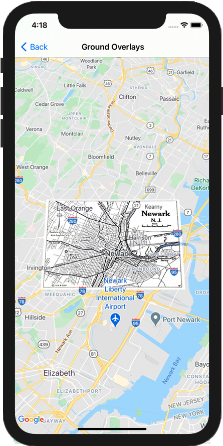
يوضّح المثال أدناه كيفية إضافة تراكب أرضي إلى عنصر GMSMapView حالي.
Swift
let southWest = CLLocationCoordinate2D(latitude: 40.712216, longitude: -74.22655)
let northEast = CLLocationCoordinate2D(latitude: 40.773941, longitude: -74.12544)
let overlayBounds = GMSCoordinateBounds(coordinate: southWest, coordinate: northEast)

// Image from http://www.lib.utexas.edu/maps/historical/newark_nj_1922.jpg
let icon = UIImage(named: "newark_nj_1922")

let overlay = GMSGroundOverlay(bounds: overlayBounds, icon: icon)
overlay.bearing = 0
overlay.map = mapView
Objective-C
CLLocationCoordinate2D southWest = CLLocationCoordinate2DMake(40.712216,-74.22655);
CLLocationCoordinate2D northEast = CLLocationCoordinate2DMake(40.773941,-74.12544);
GMSCoordinateBounds *overlayBounds = [[GMSCoordinateBounds alloc] initWithCoordinate:southWest
                                                                        coordinate:northEast];

// Image from http://www.lib.utexas.edu/maps/historical/newark_nj_1922.jpg
UIImage *icon = [UIImage imageNamed:@"newark_nj_1922"];
GMSGroundOverlay *overlay = [GMSGroundOverlay groundOverlayWithBounds:overlayBounds icon:icon];
overlay.bearing = 0;
overlay.map = mapView;
إزالة تراكب
يمكنك إزالة طبقة أرضية من الخريطة من خلال ضبط قيمة السمة map الخاصة بالعنصر GMSGroundOverlay على nil. بدلاً من ذلك، يمكنك إزالة جميع التراكبات (بما في ذلك التراكبات الأرضية المعروضة حاليًا على الخريطة) من خلال استدعاء الطريقة GMSMapView clear.
Swift
mapView.clear()
Objective-C
[mapView clear];
إذا أردت إجراء تعديلات على صورة طبقية أرضية بعد إضافتها إلى الخريطة، احرص على الاحتفاظ بكائن GMSGroundOverlay. يمكنك تعديل التراكب الأرضي لاحقًا من خلال إجراء تغييرات على هذا العنصر.
Swift
let overlay = GMSGroundOverlay(bounds: overlayBounds, icon: icon)
overlay.bearing = 0
overlay.map = mapView

// ...

overlay.isTappable = true
Objective-C
GMSGroundOverlay *overlay = [GMSGroundOverlay groundOverlayWithBounds:overlayBounds icon:icon];
overlay.bearing = 0;
overlay.map = mapView;

// ...
overlay.tappable = YES;
الفعاليات
يمكنك الاستماع إلى الأحداث التي تقع على الخريطة، مثل عندما ينقر المستخدم على تراكب. للاستماع إلى الأحداث، يجب تنفيذ البروتوكول
GMSMapViewDelegate. يمكنك الاطّلاع على
دليل الأحداث وقائمة الطرق في
GMSMapViewDelegate.