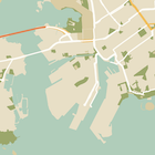
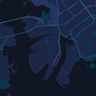
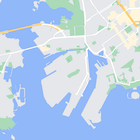
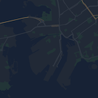
Además de cambiar el diseño de los componentes del mapa, puedes ocultarlos por completo. En este ejemplo, se muestra cómo ocultar en el mapa los lugares de interés comerciales y los íconos de transporte público.
El diseño solo funciona en el tipo de mapa kGMSTypeNormal.
Cómo aplicar diseños a tu mapa
Para aplicar diseños de mapa personalizados a un mapa, llama a GMSMapStyle(...) para crear una instancia de GMSMapStyle y pasa una URL para un archivo JSON local o una cadena JSON que contenga definiciones de diseño. Asigna la instancia de GMSMapStyle a la propiedad mapStyle del mapa.
Usa un archivo JSON
En los siguientes ejemplos, se muestra cómo llamar a GMSMapStyle(...) y pasar una URL para un archivo local:
La siguiente muestra de código presupone que tu proyecto contiene un archivo llamado style.json:
Swift
importGoogleMapsclassMapStyling:UIViewController{// Set the status bar style to complement night-mode.overridevarpreferredStatusBarStyle:UIStatusBarStyle{return.lightContent}overridefuncloadView(){letcamera=GMSCameraPosition.camera(withLatitude:-33.86,longitude:151.20,zoom:14.0)letmapView=GMSMapView.map(withFrame:CGRect.zero,camera:camera)do{// Set the map style by passing the URL of the local file.ifletstyleURL=Bundle.main.url(forResource:"style",withExtension:"json"){mapView.mapStyle=tryGMSMapStyle(contentsOfFileURL:styleURL)}else{NSLog("Unable to find style.json")}}catch{NSLog("One or more of the map styles failed to load. \(error)")}self.view=mapView}}
Objective-C
#import "MapStyling.h"@importGoogleMaps;@interfaceMapStyling()@end@implementationMapStyling// Set the status bar style to complement night-mode.-(UIStatusBarStyle)preferredStatusBarStyle{returnUIStatusBarStyleLightContent;}-(void)loadView{GMSCameraPosition*camera=[GMSCameraPositioncameraWithLatitude:-33.86longitude:151.20zoom:12];GMSMapView*mapView=[GMSMapViewmapWithFrame:CGRectZerocamera:camera];mapView.myLocationEnabled=YES;NSBundle*mainBundle=[NSBundlemainBundle];NSURL*styleUrl=[mainBundleURLForResource:@"style"withExtension:@"json"];NSError*error;// Set the map style by passing the URL for style.json.GMSMapStyle*style=[GMSMapStylestyleWithContentsOfFileURL:styleUrlerror:&error];if(!style){NSLog(@"The style definition could not be loaded: %@",error);}mapView.mapStyle=style;self.view=mapView;}@end
Para definir las opciones de diseño, agrega un archivo nuevo a tu proyecto llamado style.json y pega la siguiente declaración de diseño JSON para ocultar los lugares de interés comerciales y los íconos de transporte público:
En los siguientes ejemplos, se muestra cómo llamar a GMSMapStyle() y pasar un recurso de cadena:
Swift
classMapStylingStringResource:UIViewController{letMapStyle="JSON_STYLE_GOES_HERE"// Set the status bar style to complement night-mode.overridevarpreferredStatusBarStyle:UIStatusBarStyle{return.lightContent}overridefuncloadView(){letcamera=GMSCameraPosition.camera(withLatitude:-33.86,longitude:151.20,zoom:14.0)letmapView=GMSMapView.map(withFrame:CGRect.zero,camera:camera)do{// Set the map style by passing a valid JSON string.mapView.mapStyle=tryGMSMapStyle(jsonString:MapStyle)}catch{NSLog("One or more of the map styles failed to load. \(error)")}self.view=mapView}}
Objective-C
@implementationMapStylingStringResource// Paste the JSON string to use.staticNSString*constkMapStyle=@"JSON_STYLE_GOES_HERE";// Set the status bar style to complement night-mode.-(UIStatusBarStyle)preferredStatusBarStyle{returnUIStatusBarStyleLightContent;}-(void)loadView{GMSCameraPosition*camera=[GMSCameraPositioncameraWithLatitude:-33.86longitude:151.20zoom:12];GMSMapView*mapView=[GMSMapViewmapWithFrame:CGRectZerocamera:camera];mapView.myLocationEnabled=YES;NSError*error;// Set the map style by passing a valid JSON string.GMSMapStyle*style=[GMSMapStylestyleWithJSONString:kMapStyleerror:&error];if(!style){NSLog(@"The style definition could not be loaded: %@",error);}mapView.mapStyle=style;self.view=mapView;}@end
La siguiente declaración de diseño oculta los lugares de interés comerciales y los íconos de transporte público. Pega la siguiente cadena de estilo como el valor de la variable kMapStyle:
En los mapas con diseños, se utilizan dos conceptos para aplicar colores y otros cambios de diseño a un mapa:
Los selectores especifican los componentes geográficos a los que puedes ajustarles el diseño en el mapa. Estos componentes incluyen rutas, parques y masas de agua, entre otros, así como sus respectivas etiquetas. Los selectores incluyen componentes y elementos, que se especifican como propiedades featureType y elementType.
Los parámetros de diseño son propiedades de color y visibilidad que puedes aplicar a los elementos del mapa. Definen el color de visualización a través de una combinación de valores de tonalidad, color y luminosidad o gamma.
Consulta la referencia de diseño para acceder a una descripción detallada de las opciones de diseño del objeto JSON.
Utiliza el Asistente de diseño de Maps Platform como una forma rápida de generar un objeto de diseño JSON. El SDK de Maps para iOS admite las mismas declaraciones de diseño que la API de Maps JavaScript.
Muestras de código completas
El repositorio ApiDemos en GitHub incluye ejemplos que muestran el uso de los ajustes de diseño.
[[["Fácil de comprender","easyToUnderstand","thumb-up"],["Resolvió mi problema","solvedMyProblem","thumb-up"],["Otro","otherUp","thumb-up"]],[["Falta la información que necesito","missingTheInformationINeed","thumb-down"],["Muy complicado o demasiados pasos","tooComplicatedTooManySteps","thumb-down"],["Desactualizado","outOfDate","thumb-down"],["Problema de traducción","translationIssue","thumb-down"],["Problema con las muestras o los códigos","samplesCodeIssue","thumb-down"],["Otro","otherDown","thumb-down"]],["Última actualización: 2025-09-05 (UTC)"],[[["\u003cp\u003eLearn how to hide map features like business POIs and transit icons using the Google Maps SDK for iOS.\u003c/p\u003e\n"],["\u003cp\u003eApply custom styles by providing a local JSON file or a JSON string containing style definitions to the \u003ccode\u003emapStyle\u003c/code\u003e property of your map.\u003c/p\u003e\n"],["\u003cp\u003eUtilize the \u003ccode\u003efeatureType\u003c/code\u003e and \u003ccode\u003eelementType\u003c/code\u003e properties in your JSON to select the specific map components you want to style.\u003c/p\u003e\n"],["\u003cp\u003eControl the visibility and color of map elements through \u003ccode\u003estylers\u003c/code\u003e in your JSON style declaration.\u003c/p\u003e\n"],["\u003cp\u003eExplore the Maps Platform Styling Wizard for a user-friendly way to generate JSON styling objects for your map.\u003c/p\u003e\n"]]],["To style maps, you can hide features like business POIs and transit icons. Apply styles using `GMSMapStyle`, either with a local JSON file URL or a JSON string. Create a `style.json` file, and use selectors (features and elements) and stylers (visibility) to define map styles. Use the `mapStyle` property on the map to apply styles. Alternatively, you can define a JSON string with the same style options. You can utilize the [Maps Platform Styling Wizard](https://mapstyle.withgoogle.com) for an efficient JSON style object creation.\n"],null,["Select platform: [Android](/maps/documentation/android-sdk/hiding-features \"View this page for the Android platform docs.\") [iOS](/maps/documentation/ios-sdk/hiding-features \"View this page for the iOS platform docs.\") [JavaScript](/maps/documentation/javascript/json-styling-overview \"View this page for the JavaScript platform docs.\")\n\n\u003cbr /\u003e\n\nAs well as changing the style of features on the map, you can also hide them\nentirely. This example shows you how to hide business points of interest (POIs)\nand public transit icons on your map.\n\nStyling works only on the `kGMSTypeNormal` map type.\n\nApplying styles to your map\n\nTo apply custom map styles to a map, call `GMSMapStyle(...)` to create a\n`GMSMapStyle` instance, passing in a URL for a local JSON file, or a JSON\nstring containing style definitions. Assign the `GMSMapStyle` instance to the\n`mapStyle` property of the map.\n\nUsing a JSON file\n\nThe following examples show calling `GMSMapStyle(...)` and passing a URL for a\nlocal file:\n\nThe following code sample assumes your project contains a file named\n`style.json`:\n\n\nSwift \n\n```swift\nimport GoogleMaps\n\nclass MapStyling: UIViewController {\n\n // Set the status bar style to complement night-mode.\n override var preferredStatusBarStyle: UIStatusBarStyle {\n return .lightContent\n }\n\n override func loadView() {\n let camera = GMSCameraPosition.camera(withLatitude: -33.86, longitude: 151.20, zoom: 14.0)\n let mapView = GMSMapView.map(withFrame: CGRect.zero, camera: camera)\n\n do {\n // Set the map style by passing the URL of the local file.\n if let styleURL = Bundle.main.url(forResource: \"style\", withExtension: \"json\") {\n mapView.mapStyle = try GMSMapStyle(contentsOfFileURL: styleURL)\n } else {\n NSLog(\"Unable to find style.json\")\n }\n } catch {\n NSLog(\"One or more of the map styles failed to load. \\(error)\")\n }\n\n self.view = mapView\n }\n}\n \n```\n\nObjective-C \n\n```objective-c\n#import \"MapStyling.h\"\n@import GoogleMaps;\n\n@interface MapStyling ()\n\n@end\n\n@implementation MapStyling\n\n// Set the status bar style to complement night-mode.\n- (UIStatusBarStyle)preferredStatusBarStyle {\n return UIStatusBarStyleLightContent;\n}\n\n- (void)loadView {\n GMSCameraPosition *camera = [GMSCameraPosition cameraWithLatitude:-33.86\n longitude:151.20\n zoom:12];\n GMSMapView *mapView = [GMSMapView mapWithFrame:CGRectZero camera:camera];\n mapView.myLocationEnabled = YES;\n\n NSBundle *mainBundle = [NSBundle mainBundle];\n NSURL *styleUrl = [mainBundle URLForResource:@\"style\" withExtension:@\"json\"];\n NSError *error;\n\n // Set the map style by passing the URL for style.json.\n GMSMapStyle *style = [GMSMapStyle styleWithContentsOfFileURL:styleUrl error:&error];\n\n if (!style) {\n NSLog(@\"The style definition could not be loaded: %@\", error);\n }\n\n mapView.mapStyle = style;\n self.view = mapView;\n}\n\n@end\n \n```\n\n\u003cbr /\u003e\n\nTo define the style options, add a new file to your project named `style.json`,\nand paste the following JSON style declaration to hide business points of\ninterest (POIs) and public transit icons:\nShow/Hide the JSON. \n\n```text\n[\n {\n \"featureType\": \"poi.business\",\n \"elementType\": \"all\",\n \"stylers\": [\n {\n \"visibility\": \"off\"\n }\n ]\n },\n {\n \"featureType\": \"transit\",\n \"elementType\": \"labels.icon\",\n \"stylers\": [\n {\n \"visibility\": \"off\"\n }\n ]\n }\n]\n```\n\nUsing a string resource\n\nThe following examples show calling `GMSMapStyle()` and passing a string\nresource:\n\n\nSwift \n\n```swift\nclass MapStylingStringResource: UIViewController {\n\n let MapStyle = \"JSON_STYLE_GOES_HERE\"\n\n // Set the status bar style to complement night-mode.\n override var preferredStatusBarStyle: UIStatusBarStyle {\n return .lightContent\n }\n\n override func loadView() {\n let camera = GMSCameraPosition.camera(withLatitude: -33.86, longitude: 151.20, zoom: 14.0)\n let mapView = GMSMapView.map(withFrame: CGRect.zero, camera: camera)\n\n do {\n // Set the map style by passing a valid JSON string.\n mapView.mapStyle = try GMSMapStyle(jsonString: MapStyle)\n } catch {\n NSLog(\"One or more of the map styles failed to load. \\(error)\")\n }\n\n self.view = mapView\n }\n}\n \n```\n\nObjective-C \n\n```objective-c\n@implementation MapStylingStringResource\n\n// Paste the JSON string to use.\nstatic NSString *const kMapStyle = @\"JSON_STYLE_GOES_HERE\";\n\n// Set the status bar style to complement night-mode.\n- (UIStatusBarStyle)preferredStatusBarStyle {\n return UIStatusBarStyleLightContent;\n}\n\n- (void)loadView {\n GMSCameraPosition *camera = [GMSCameraPosition cameraWithLatitude:-33.86\n longitude:151.20\n zoom:12];\n GMSMapView *mapView = [GMSMapView mapWithFrame:CGRectZero camera:camera];\n mapView.myLocationEnabled = YES;\n\n NSError *error;\n\n // Set the map style by passing a valid JSON string.\n GMSMapStyle *style = [GMSMapStyle styleWithJSONString:kMapStyle error:&error];\n\n if (!style) {\n NSLog(@\"The style definition could not be loaded: %@\", error);\n }\n\n mapView.mapStyle = style;\n self.view = mapView;\n}\n\n@end\n \n```\n\n\u003cbr /\u003e\n\nThe following style declaration hides business points of interest (POIs) and\npublic transit icons. Paste the following style string as the value of\nthe `kMapStyle` variable:\nShow/Hide the JSON. \n\n```objective-c\n@\"[\"\n@\" {\"\n@\" \\\"featureType\\\": \\\"poi.business\\\",\"\n@\" \\\"elementType\\\": \\\"all\\\",\"\n@\" \\\"stylers\\\": [\"\n@\" {\"\n@\" \\\"visibility\\\": \\\"off\\\"\"\n@\" }\"\n@\" ]\"\n@\" },\"\n@\" {\"\n@\" \\\"featureType\\\": \\\"transit\\\",\"\n@\" \\\"elementType\\\": \\\"labels.icon\\\",\"\n@\" \\\"stylers\\\": [\"\n@\" {\"\n@\" \\\"visibility\\\": \\\"off\\\"\"\n@\" }\"\n@\" ]\"\n@\" }\"\n@\"]\"\n```\n\nJSON style declarations\n\nStyled maps use two concepts to apply colors and other style changes to a\nmap:\n\n- **Selectors** specify the geographic components that you can style on the map. These include roads, parks, bodies of water, and more, as well as their labels. The selectors include *features* and *elements* , specified as `featureType` and `elementType` properties.\n- **Stylers** are color and visibility properties that you can apply to map elements. They define the displayed color through a combination of hue, color, and lightness/gamma values.\n\nSee the [style reference](/maps/documentation/ios-sdk/style-reference) for a detailed description of the\nJSON styling options.\n\nMaps Platform Styling Wizard \n[](https://mapstyle.withgoogle.com) \n[](https://mapstyle.withgoogle.com) \n[](https://mapstyle.withgoogle.com)[](https://mapstyle.withgoogle.com/) \n[](https://mapstyle.withgoogle.com/) \n[](https://mapstyle.withgoogle.com/) \n[](https://mapstyle.withgoogle.com/) \n[](https://mapstyle.withgoogle.com/) \n[](https://mapstyle.withgoogle.com/) \n[Create\ncustom styles for the Google Maps Platform APIs](https://mapstyle.withgoogle.com)\n\nUse the [Maps Platform Styling Wizard](https://mapstyle.withgoogle.com) as a quick way\nto generate a JSON styling object. The Maps SDK for iOS supports the\nsame style declarations as the Maps JavaScript API.\n\nFull code samples\n\nThe [ApiDemos repository](https://github.com/googlemaps-samples/maps-sdk-for-ios-samples) on GitHub includes\nsamples that demonstrate the use of styling."]]