

لاستخدام التنسيق المستند إلى البيانات للحدود، يجب إنشاء معرّف خريطة. بعد ذلك، عليك إنشاء نمط خريطة جديد واختيار طبقات معالم الحدود المطلوبة وربط النمط بمعرّف الخريطة.
إنشاء رقم تعريف خريطة
mapID هو معرّف فريد يمثّل نسخة واحدة من "خرائط Google". يمكنك إنشاء معرّفات خرائط وتعديل نمط مرتبط بمعرّف خريطة في أي وقت في Google Cloud Console.
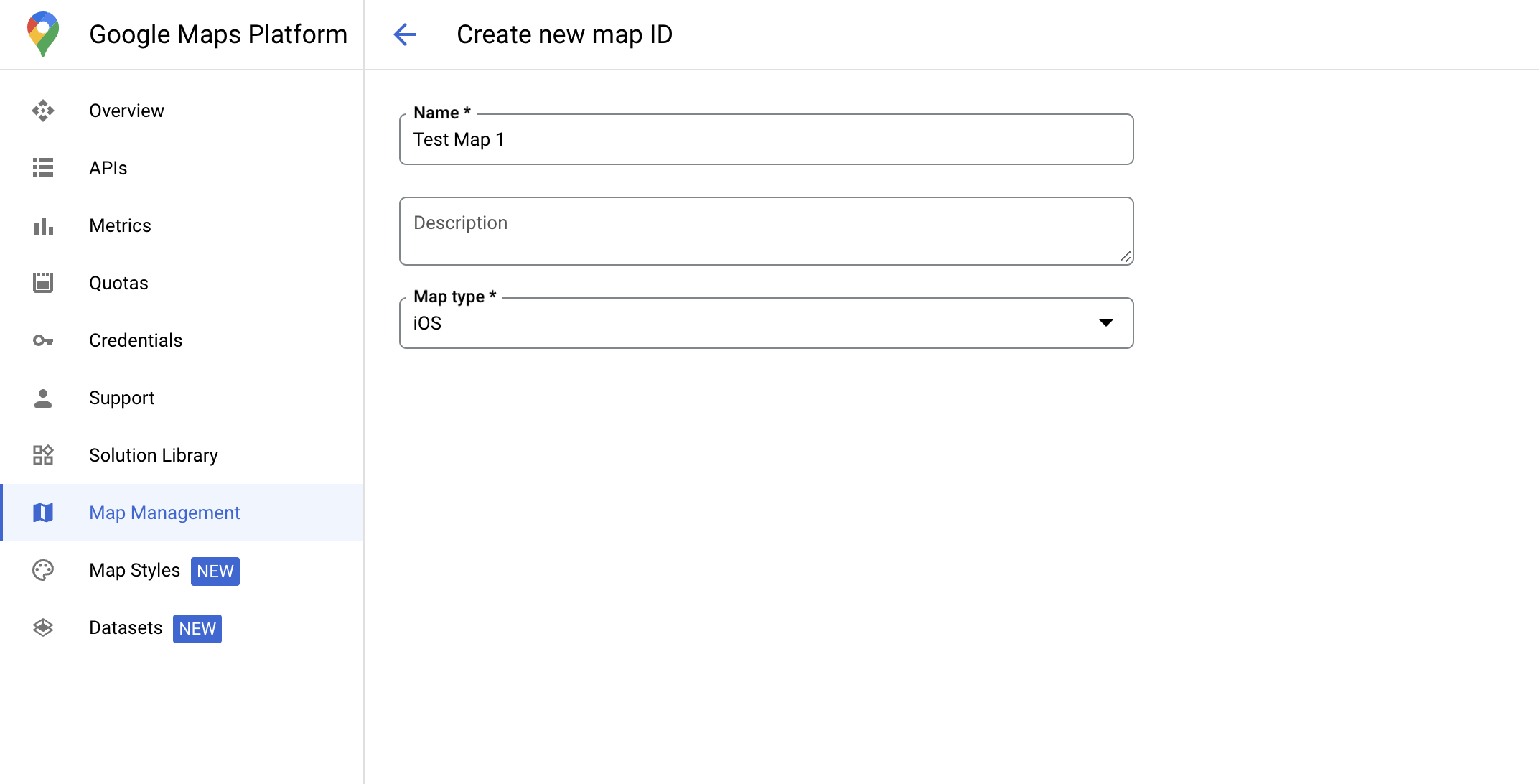
إنشاء نمط خريطة جديد
لإنشاء نمط خريطة جديد، اتّبِع التعليمات الواردة في إدارة أنماط الخرائط لإنشاء النمط. بعد اكتمال العملية، اربط النمط بمعرّف الخريطة الذي تم إنشاؤه حديثًا.
اختيار طبقات المعالم
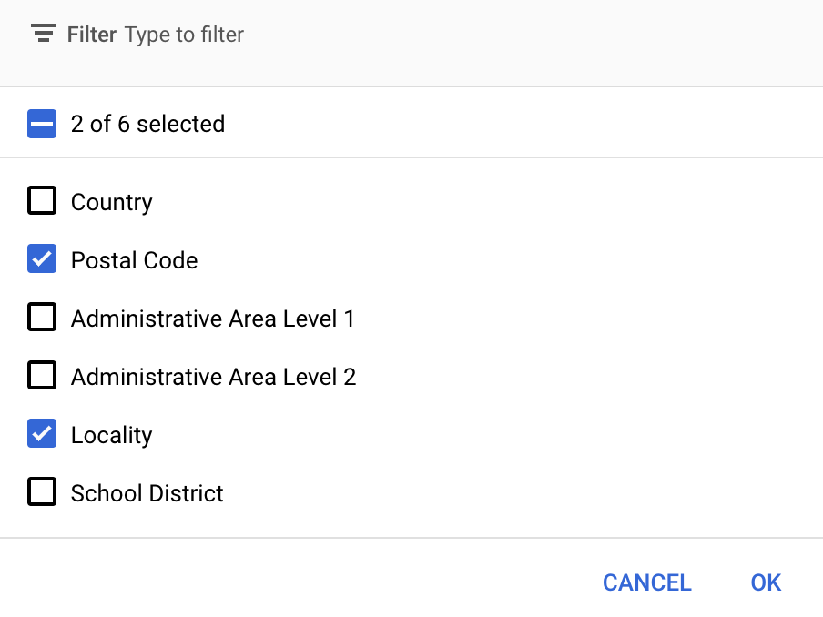
في Google Cloud Console، يمكنك اختيار طبقات الميزات التي تريد عرضها. يحدّد هذا النوع الحدود التي تظهر على الخريطة (مثل المناطق المحلية والولايات وما إلى ذلك).
إدارة طبقات المعالم
في Google Cloud Console، انتقِل إلى صفحة "أنماط الخرائط".
اختَر مشروعًا إذا طُلب منك ذلك.
اختَر نمط خريطة.
انقر على القائمة المنسدلة طبقات الميزات لإضافة طبقات أو إزالتها.
انقر على حفظ لحفظ التغييرات وإتاحتها في خرائطك.
تعديل رمز تهيئة الخريطة
تتطلّب هذه الخطوة ربط معرّف خريطة بنمط يتضمّن طبقة واحدة أو أكثر من طبقات الميزات المفعّلة. للتأكّد من إعداد معرّف الخريطة بشكل صحيح في Cloud Console، راجِع طريقة إعداده ضمن إدارة الخرائط.
Swift
// A map ID using a style with one or more feature layers enabled

let mapID = GMSMapID(identifier: "YOUR_MAP_ID")
let camera = GMSCameraPosition(latitude: 40, longitude: -80, zoom: 7)
let options = GMSMapViewOptions()
options.camera = camera
options.mapID = mapID
let mapView = GMSMapView(options: options)
Objective-C
// A map ID using a style with one or more feature layers enabled

GMSMapID *mapID = [GMSMapID mapIDWithIdentifier:@"MAP_ID"];
GMSCameraPosition *camera = [GMSCameraPosition cameraWithLatitude:40 longitude:-80 zoom:7];
GMSMapViewOptions *options = [[GMSMapViewOptions alloc] init];
options.camera = camera;
options.mapID = mapID;
GMSMapView *mapView = [[GMSMapView alloc] initWithOptions:options];
إضافة طبقات معالم إلى خريطة
للحصول على مرجع إلى طبقة معالم على خريطتك، استدعِ
mapView.featureLayer(of:)
عندما يتم تهيئة الخريطة:
Swift
let layer = mapView.featureLayer(of: .locality)
Objective-C
GMSFeatureLayer*layer = [mapView featureLayerOfFeatureType:GMSFeatureTypeLocality];
التحقّق من إمكانات الخريطة
تتطلّب ميزة "تصميم مستند إلى البيانات" للحدود إمكانات يتم تفعيلها في Google Cloud Console، ويتم ربطها بمعرّف خريطة. بما أنّ معرّفات الخرائط قابلة للتغيير، يمكنك طلب mapView.mapCapabilities على GMSMapView للتحقّق مما إذا كانت إمكانية معيّنة (مثل التنسيق المستند إلى البيانات) متاحة قبل طلبها.
يمكنك أيضًا رصد التغييرات في إمكانات الخريطة من خلال الاشتراك في
GMSViewDelegate. يوضّح هذا المثال كيفية استخدام البروتوكول للتحقّق من متطلبات التنسيق المستند إلى البيانات.
Swift
class SampleViewController: UIViewController {

  private lazy var mapView: GMSMapView = {
    let options = GMSMapViewOptions()
    options.mapID = GMSMapID(identifier: "YOUR_MAP_ID")
    options.camera = GMSCameraPosition(latitude: 40, longitude: -80, zoom: 7)
    return GMSMapView(options: options)
  }()

  override func loadView() {
    self.view = mapView
    mapView.delegate = self
  }
}

extension SampleViewController: GMSMapViewDelegate {
  func mapView(_ mapView: GMSMapView, didChange mapCapabilities: GMSMapCapabilityFlags) {
    if (!mapCapabilities.contains(.dataDrivenStyling)) {
      // Data-driven styling is *not* available, add a fallback.
      // Existing feature layers are also unavailable.
    }
  }
}
Objective-C
@interface SampleViewController: UIViewController <GMSMapViewDelegate>
@end

@implementation SampleViewController
- (void)loadView {
  GMSCameraPosition *camera = [GMSCameraPosition cameraWithLatitude:40 longitude:-80 zoom:7];
  GMSMapViewOptions *options = [[GMSMapViewOptions alloc] init];
  options.camera = camera;
  options.mapID = [GMSMapID mapIDWithIdentifier:@"MAP_ID"];
  GMSMapView *mapView = [[GMSMapView alloc] initWithOptions:options];
  mapView.delegate = self;
  self.view = mapView;
}

- (void)mapView:(GMSMapView *)mapView didChangeMapCapabilities:(GMSMapCapabilityFlags)mapCapabilities {
  if (!(mapCapabilities & GMSMapCapabilityFlagsDataDrivenStyling)) {
    // Data-driven styling is *not* available, add a fallback.
    // Existing feature layers are also unavailable.
  }
}
@end