
Page Summary
-
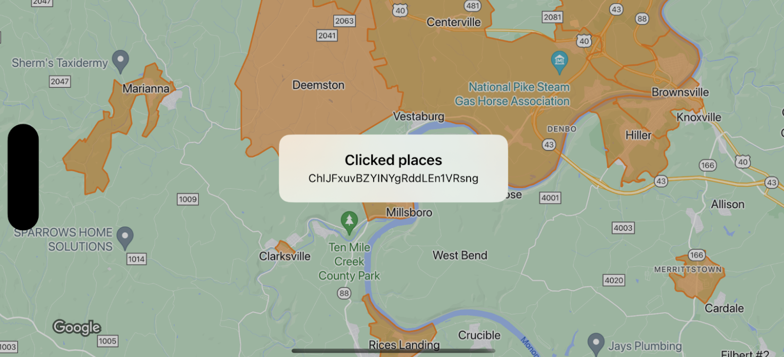
This documentation demonstrates handling click events on map boundaries, specifically using
GMSFeatureTypeLocalityfor the example. -
When a boundary is clicked, an info window appears displaying event data, such as the place IDs of the clicked features.
-
It's crucial to note that map boundaries need a minimum alpha value for click events to register, ensuring they are tappable.
-
Sample code snippets in Swift and Objective-C are provided for implementation guidance on setting up and responding to click events on map boundaries.
This example shows map boundaries for
GMSFeatureTypeLocality, and implements the
delegate function that styles the clicked
polygon. The result displays an info alert window with the event data.
Swift
class SampleViewController: UIViewController {

  private lazy var mapView: GMSMapView = GMSMapView(frame: .zero, mapID: GMSMapID(identifier: "YOUR_MAP_ID"), camera: GMSCameraPosition(latitude: 40, longitude: -80, zoom: 12))

  override func loadView() {
    view = mapView
    let style = FeatureStyle(fill: .orange.withAlphaComponent(0.5), stroke: .orange, strokeWidth: 2)
    mapView.featureLayer(of: .locality).style = { _ in style }
    mapView.delegate = self
  }
}

extension SampleViewController: GMSMapViewDelegate {
  func mapView(_ mapView: GMSMapView, didTap features: [Feature], in featureLayer: FeatureLayer<Feature>, atLocation: CLLocationCoordinate2D) {
    let toast = UIAlertController(title: "Clicked places", message: (features.compactMap { ($0 as? PlaceFeature)?.placeID }).joined(separator: ", "), preferredStyle: .alert)
    present(toast, animated: true, completion: nil)
  }
}
Objective-C
@interface SampleViewController: UIViewController <GMSMapViewDelegate>
@end

@implementation SampleViewController
- (void)loadView {
    GMSMapView *mapView = [GMSMapView mapWithFrame:CGRectZero mapID:[GMSMapID mapIDWithIdentifier:@"YOUR_MAP_ID"] camera:[GMSCameraPosition cameraWithLatitude:40 longitude:-80 zoom:12]];
    mapView.delegete = self;

    GMSFeatureStyle *style = [GMSFeatureStyle styleWithFillColor:[[UIColor orangeColor] colorWithAlphaComponent:0.5] strokeColor:[UIColor orangeColor] strokeWidth:2.0];
    [mapView featureLayerOfFeatureType:GMSFeatureTypeLocality].style = ^(GMSPlaceFeature *feature) { return style; };

    self.view = mapView;
}

- (void)mapView:(GMSMapView *)mapView didTapFeatures:(NSArray<id<GMSFeature>> *)features inFeatureLayer:(GMSFeatureLayer *)featureLayer atLocation:(CLLocationCoordinate2D)location {
  NSMutableArray<NSString *> *places = [NSMutableArray array];

  for (id<GMSFeature> feature in features) {
    if (![feature isKindOfClass:[GMSPlaceFeature class]]) { continue; }
    NSString *placeID = ((GMSPlaceFeature *)feature).placeID;
    [places addObject:placeID];
  }

  UIAlertController *toast = [UIAlertController alertControllerWithTitle:@"Clicked places" message:[places componentsJoinedByString:@", "] preferredStyle:UIAlertControllerStyleAlert];
  [self presentViewController:toast animated:YES completion:nil];
}