
Page Summary
-
Map features are arranged hierarchically, allowing customization by inheriting styles from the base map, parent features, or overriding them for specific features or zoom levels.
-
You can customize the visibility, fill color, stroke color, stroke width, icon color, text fill color, and text stroke color of various map features.
-
Some features like political boundaries and 3D buildings have limited styling options to maintain their meaning or visual representation.
-
The platform provides styling options for various categories like points of interest, political boundaries, infrastructure, and natural elements.
-
Customization options are available for specific elements within each category, for example, under "Points of Interest," you can customize styles for "Emergency," "Entertainment," and other subcategories.
The map features you can customize are arranged in a hierarchy, and each map feature has one or more style elements that you can customize. Most top-level features have one or more child map features. You have several options when customizing map styles:
Inherit from the base map style: If you don't customize a style element for a map feature, it inherits the default style from the base map.
Inherit from parents: Customize a style element on a parent map feature, to have all un-customized child map features below inherit the styles from their parent.
Override the parent style: Customize a style element on a child map feature to override the parent style for that element.
Customize zoom levels: For some map features, you can customize style elements for different zoom levels. For details, see Style zoom levels.
What you can style for each map feature
Map features can have one or more of the following style elements that you can customize, depending on the type of map feature:
Visibility: Whether to show or hide this feature on the map.
Fill color: Fill color for polygons and polylines.
Stroke color: Outline color for polygons and polylines.
Stroke width: Thickness of the outline for polygons and polylines. Results may vary depending on the zoom level. If you don't want an outline, set the Stroke color to be the same as the Fill color, or set the Stroke width to 0.
Icon color: Fill color for non-POI icons.
Pin outline color: Outline color for the Point of interest pins.
Pin fill color: Fill color for the Point of interest pins.
Pin glyph color: Glyph color for the Point of interest pins.
Text fill color: Fill color for text labels.
Text stroke color: Outline color for text labels.
Map feature visibility
When you hide map features or make them transparent, you may expose boundary inaccuracies. Map feature boundaries are not always precise, but are adjusted to look correct when all layers are visible. To learn more about how map layers affect each other, see Manage styles that overlap.
There are two ways to show or hide map features: visibility and opacity.
Visibility
To either display or hide a map feature on your map, use the Visibility style element. For more details, see Filter which map features to display.
Opacity
You can also make a map feature transparent by adjusting the opacity of the following style elements: Fill color, Stroke color, Text fill color, and Text stroke color.


When you adjust the opacity of a map feature, its appearance depends on the map features underneath. To avoid unexpected style changes, set a custom style for all overlapping features.
Polygons and Polylines
For map feature types that are represented with a shape, such as Beach, Country, and Town square, or a line, such as Railway track, Highway, and Trail, you can typically style the following elements: Visibility, Fill color, Stroke color, and Stroke width.
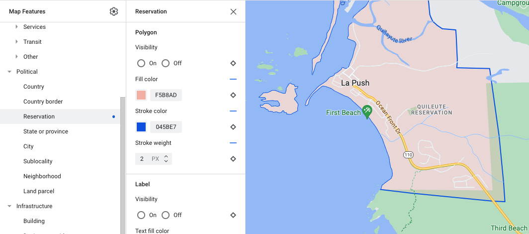
Polygon styling customization example - for Reservation feature type
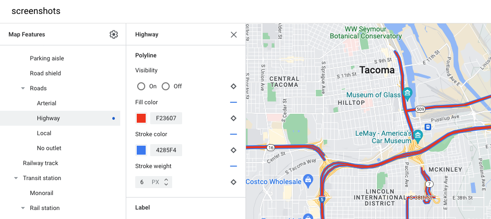
Polyline styling customization example - for Highway feature type
Stroke color and Stroke width customizations are not available for the following map features:
Political map features: Their style conveys meaning on the map, such as indicating the type of territory. The political map features are Country, Border, State or province, and Sublocality.
3D style buildings.
Icons and Text Labels
For map feature types that are fully or partially represented with a label, such as Transportation and other non-Point of interest types, you can usually style the following elements: Visibility, Icon color, Text fill color, and Text stroke color.
![]()
Icon styling and label text customizations example
Pins
You can style Point of interest map feature types with the following elements: Visibility, Pin outline color, Pin fill color, Pin glyph color, Text fill color, and Text stroke color.
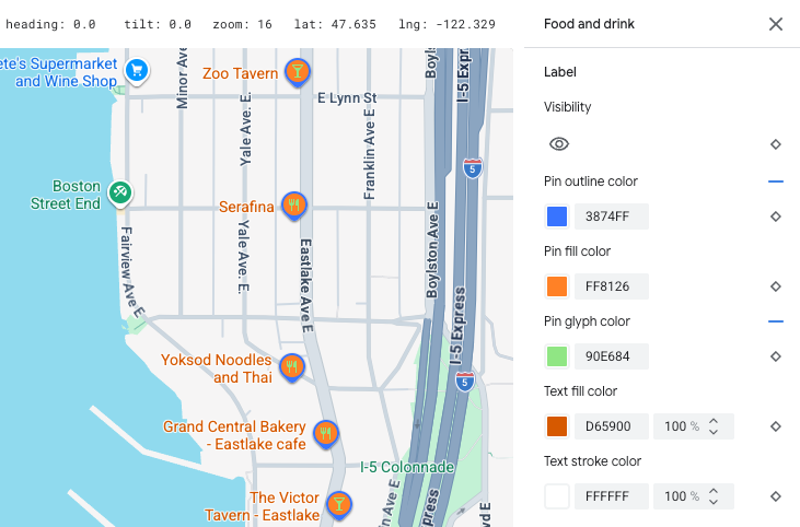
Pin styling and label text customizations example
Map feature hierarchy
These tables for the top level map features show what child map features are available under each.
Point of interest |
||
|---|---|---|
| Emergency | Fire Hospital Pharmacy Police |
|
| Entertainment | Arts Casino Cinema Historic Museum Theme park Tourist attraction |
|
| Food and drink | Bar Cafe Restaurant Winery |
|
| Landmark | ||
| Lodging | ||
| Recreation | Beach Boating Fishing Golf course Hot spring Nature reserve Park Peak Sports complex Sports field Trailhead Zoo |
|
| Retail | Grocery Shopping |
|
| Service | ATM Bank Car rental EV charging Gas station Parking lot Post office Rest stop Restroom |
|
| Transit | Airport | |
| Other | Bridge | |
| Cemetery | ||
| Government | ||
| Library | ||
| Military | ||
| Place of worship | Buddhist Christian Hindu Islamic Jain Jewish Shinto Sikh |
|
| School | ||
| Town square | ||
Political |
|
|---|---|
| Country | |
| Border | |
| Reservation | |
| State or province | |
| City | |
| Sublocality | |
| Neighborhood | |
| Land parcel | |
Infrastructure |
|||
|---|---|---|---|
| * Road detail map features are only available on Google Maps Platform products that have road level details enabled. For more information, see Road level details for Google Maps Platform. | |||
| Building | Commercial Indoor |
||
| Business corridor | |||
| Road network | No traffic | Pedestrian mall | |
| Trail | Paved Unpaved |
||
| Parking aisle | |||
| Ramp | |||
| Road shield | |||
| Road sign | |||
| Road | Arterial Highway Local No outlet |
||
| Road detail* | Surface Crosswalk Sidewalk Intersection Direction arrow |
||
| Railway track | Commercial Commuter |
||
| Transit station | Bicycle share | ||
| Bus station | |||
| Ferry terminal | |||
| Funicular station | |||
| Gondola station | |||
| Monorail | |||
| Rail station | Subway station Tram station |
||
| Urban area | |||
Natural |
||
|---|---|---|
| † Land cover map features are rough approximations based on satellite imagery colors and may not accurately reflect real-world conditions. | ||
| Continent | ||
| Archipelago | ||
| Island | ||
| Land | Land cover† | Crops Dry crops Forest Ice Sand Shrub Tundra |
| Water | Ocean Lake River Other |
|
| Base | ||