Наземные наложения — это наложения на карте, привязанные к координатам широты/долготы, поэтому они перемещаются при перетаскивании или масштабировании карты.
Введение
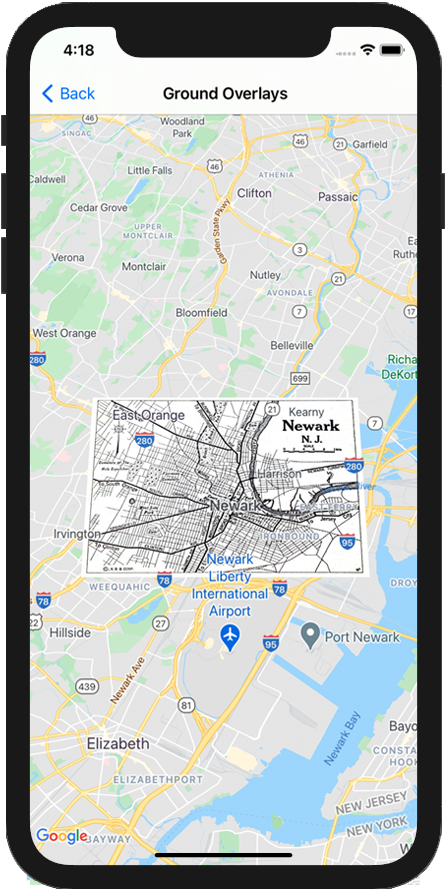
Наземное наложение — это изображение, закреплённое на карте. В отличие от маркеров , наземные наложения ориентированы относительно поверхности Земли, а не экрана, поэтому поворот, наклон или масштабирование карты изменят ориентацию изображения.
Чтобы добавить наложение земной поверхности, создайте объект GMSGroundOverlay , который определяет как значок, так и границы. Если не указать ни один из этих параметров, наложение земной поверхности не будет отображаться на карте. При желании вы можете указать дополнительные параметры, которые повлияют на расположение изображения на карте. После определения необходимых параметров настройте свойство map этого объекта, чтобы добавить наложение.
Добавление наложения
Создать новый объект GMSGroundOverlay
Установите свойство icon для экземпляра UIImage .
Установите свойство bounds для экземпляра GMSCoordinateBounds . Границы представляют юго-западный и северо-восточный углы изображения.
При необходимости задайте дополнительные свойства, такие как bearing и zoomLevel .
Установите свойство map — изображение появится на карте.
В примере ниже показано, как добавить наложение земной поверхности к существующему объекту GMSMapView .
Быстрый
letsouthWest=CLLocationCoordinate2D(latitude:40.712216,longitude:-74.22655)letnorthEast=CLLocationCoordinate2D(latitude:40.773941,longitude:-74.12544)letoverlayBounds=GMSCoordinateBounds(coordinate:southWest,coordinate:northEast)// Image from http://www.lib.utexas.edu/maps/historical/newark_nj_1922.jpgleticon=UIImage(named:"newark_nj_1922")letoverlay=GMSGroundOverlay(bounds:overlayBounds,icon:icon)overlay.bearing=0overlay.map=mapView
Objective-C
CLLocationCoordinate2DsouthWest=CLLocationCoordinate2DMake(40.712216,-74.22655);CLLocationCoordinate2DnorthEast=CLLocationCoordinate2DMake(40.773941,-74.12544);GMSCoordinateBounds*overlayBounds=[[GMSCoordinateBoundsalloc]initWithCoordinate:southWestcoordinate:northEast];// Image from http://www.lib.utexas.edu/maps/historical/newark_nj_1922.jpgUIImage*icon=[UIImageimageNamed:@"newark_nj_1922"];GMSGroundOverlay*overlay=[GMSGroundOverlaygroundOverlayWithBounds:overlayBoundsicon:icon];overlay.bearing=0;overlay.map=mapView;
Удаление наложения
Вы можете удалить наземное наложение с карты, установив свойство map объекта GMSGroundOverlay в значение nil . Кроме того, вы можете удалить все наложения (включая наземные наложения, которые в данный момент находятся на карте), вызвав метод clear объекта GMSMapView .
Быстрый
mapView.clear()
Objective-C
[mapViewclear];
Если вы хотите внести изменения в наземное покрытие после его добавления на карту, убедитесь, что у вас сохранился объект GMSGroundOverlay . Вы сможете изменить наземное покрытие позже, внеся изменения в этот объект.
[[["Прост для понимания","easyToUnderstand","thumb-up"],["Помог мне решить мою проблему","solvedMyProblem","thumb-up"],["Другое","otherUp","thumb-up"]],[["Отсутствует нужная мне информация","missingTheInformationINeed","thumb-down"],["Слишком сложен/слишком много шагов","tooComplicatedTooManySteps","thumb-down"],["Устарел","outOfDate","thumb-down"],["Проблема с переводом текста","translationIssue","thumb-down"],["Проблемы образцов/кода","samplesCodeIssue","thumb-down"],["Другое","otherDown","thumb-down"]],["Последнее обновление: 2025-09-04 UTC."],[[["\u003cp\u003eGround overlays are images fixed to a map, oriented to the Earth's surface, and change orientation with map interactions.\u003c/p\u003e\n"],["\u003cp\u003eTo add a ground overlay, create a \u003ccode\u003eGMSGroundOverlay\u003c/code\u003e object, define its icon, bounds, and optional settings, then set its \u003ccode\u003emap\u003c/code\u003e property.\u003c/p\u003e\n"],["\u003cp\u003eGround overlays can be removed by setting the \u003ccode\u003emap\u003c/code\u003e property to \u003ccode\u003enil\u003c/code\u003e or using the \u003ccode\u003eclear\u003c/code\u003e method on the \u003ccode\u003eGMSMapView\u003c/code\u003e.\u003c/p\u003e\n"],["\u003cp\u003eModifications to existing ground overlays can be made by accessing and updating the \u003ccode\u003eGMSGroundOverlay\u003c/code\u003e object directly.\u003c/p\u003e\n"],["\u003cp\u003eImplement the \u003ccode\u003eGMSMapViewDelegate\u003c/code\u003e protocol to listen to events like user taps on the overlay.\u003c/p\u003e\n"]]],["Ground overlays, images fixed to a map using latitude/longitude, are added by creating a `GMSGroundOverlay` object. This requires setting both the `icon` (an image) and `bounds` (southwest/northeast coordinates). Optionally, set properties like `bearing` and `zoomLevel`. To display, assign the object's `map` property. Overlays are removed by setting `map` to `nil` or using the `clear` method. Modifications require retaining the `GMSGroundOverlay` object and to listen for events, you must implement `GMSMapViewDelegate`.\n"],null,["Select platform: [Android](/maps/documentation/android-sdk/groundoverlay \"View this page for the Android platform docs.\") [iOS](/maps/documentation/ios-sdk/overlays \"View this page for the iOS platform docs.\") [JavaScript](/maps/documentation/javascript/groundoverlays \"View this page for the JavaScript platform docs.\")\n\n\u003cbr /\u003e\n\nGround overlays are overlays on the map that are tied to latitude/longitude\ncoordinates, so they move when you drag or zoom the map.\n\nIntroduction\n\nA ground overlay is an image that is fixed to a map. Unlike\n[markers](/maps/documentation/ios-sdk/marker), ground overlays are oriented against the Earth's surface\nrather than the screen, so rotating, tilting or zooming the map will change\nthe orientation of the image.\n\nTo add a ground overlay, create a\n[`GMSGroundOverlay`](/maps/documentation/ios-sdk/reference/objc/Classes/GMSGroundOverlay)\nobject that defines both an icon and a bounds. Failing to specify either will\ncause the ground overlay to not appear on the map. You can optionally specify\nadditional settings that will affect the positioning of the image on the map.\nOnce you've defined the necessary options, set this object's `map` property to\nadd the overlay.\n\nAdding an overlay\n\n1. Instantiate a new `GMSGroundOverlay` object\n2. Set the `icon` property to an instance of `UIImage`.\n3. Set the `bounds` property to an instance of `GMSCoordinateBounds`. The bounds represent the south west, and north east corners of the image.\n4. Set optional properties, such as `bearing` and `zoomLevel`, as desired.\n5. Set the `map` property - the image appears on the map.\n\nThe below example demonstrates how to add a ground overlay to an existing\n`GMSMapView` object.\n\n\nSwift \n\n```swift\nlet southWest = CLLocationCoordinate2D(latitude: 40.712216, longitude: -74.22655)\nlet northEast = CLLocationCoordinate2D(latitude: 40.773941, longitude: -74.12544)\nlet overlayBounds = GMSCoordinateBounds(coordinate: southWest, coordinate: northEast)\n\n// Image from http://www.lib.utexas.edu/maps/historical/newark_nj_1922.jpg\nlet icon = UIImage(named: \"newark_nj_1922\")\n\nlet overlay = GMSGroundOverlay(bounds: overlayBounds, icon: icon)\noverlay.bearing = 0\noverlay.map = mapView\n \n```\n\nObjective-C \n\n```objective-c\nCLLocationCoordinate2D southWest = CLLocationCoordinate2DMake(40.712216,-74.22655);\nCLLocationCoordinate2D northEast = CLLocationCoordinate2DMake(40.773941,-74.12544);\nGMSCoordinateBounds *overlayBounds = [[GMSCoordinateBounds alloc] initWithCoordinate:southWest\n coordinate:northEast];\n\n// Image from http://www.lib.utexas.edu/maps/historical/newark_nj_1922.jpg\nUIImage *icon = [UIImage imageNamed:@\"newark_nj_1922\"];\nGMSGroundOverlay *overlay = [GMSGroundOverlay groundOverlayWithBounds:overlayBounds icon:icon];\noverlay.bearing = 0;\noverlay.map = mapView;\n \n```\n\n\u003cbr /\u003e\n\nRemoving an overlay\n\nYou can remove a ground overlay from the map by setting your\n`GMSGroundOverlay`'s `map` property to `nil`. Alternately, you can remove all\nof the overlays (including ground overlays currently on the map by calling the\n`GMSMapView` `clear` method.\n\n\nSwift \n\n```swift\nmapView.clear()\n \n```\n\nObjective-C \n\n```objective-c\n[mapView clear];\n \n```\n\n\u003cbr /\u003e\n\nIf you wish to make modifications to a ground overlay after you've added it to\nthe map, ensure that you keep hold of the `GMSGroundOverlay` object. You can\nmodify the ground overlay later by making changes to this object.\n\n\nSwift \n\n```swift\nlet overlay = GMSGroundOverlay(bounds: overlayBounds, icon: icon)\noverlay.bearing = 0\noverlay.map = mapView\n\n// ...\n\noverlay.isTappable = true\n \n```\n\nObjective-C \n\n```objective-c\nGMSGroundOverlay *overlay = [GMSGroundOverlay groundOverlayWithBounds:overlayBounds icon:icon];\noverlay.bearing = 0;\noverlay.map = mapView;\n\n// ...\noverlay.tappable = YES;\n \n```\n\n\u003cbr /\u003e\n\nEvents\n\nYou can listen to events that occur on the map, such as when a user taps an\noverlay. To listen to events, you must implement the\n[`GMSMapViewDelegate`](/maps/documentation/ios-sdk/reference/objc/Protocols/GMSMapViewDelegate) protocol. See the\n[guide to events](/maps/documentation/ios-sdk/events) and the list of methods on the\n[`GMSMapViewDelegate`](/maps/documentation/ios-sdk/reference/objc/Protocols/GMSMapViewDelegate)."]]