Overlay bumi adalah overlay di peta yang terikat dengan koordinat garis lintang/bujur, sehingga akan bergerak saat Anda menarik atau melakukan zoom pada peta.
Pengantar
Overlay bumi adalah gambar yang disematkan pada peta. Tidak seperti
penanda, overlay bumi berorientasi pada permukaan Bumi, bukan layar, sehingga memutar, memiringkan, atau melakukan zoom pada peta akan mengubah orientasi gambar.
Untuk menambahkan overlay tanah, buat objek
GMSGroundOverlay yang menentukan ikon dan batas. Jika tidak menentukan salah satunya, overlay bumi tidak akan muncul di peta. Secara opsional, Anda dapat menentukan setelan tambahan yang akan memengaruhi pemosisian gambar pada peta.
Setelah menentukan opsi yang diperlukan, tetapkan properti map objek ini untuk menambahkan overlay.
Menambahkan overlay
Membuat instance objek GMSGroundOverlay baru
Tetapkan properti icon ke instance UIImage.
Tetapkan properti bounds ke instance GMSCoordinateBounds. Batas
mewakili sudut barat daya dan timur laut gambar.
Tetapkan properti opsional, seperti bearing dan zoomLevel, sesuai keinginan.
Tetapkan properti map - gambar akan muncul di peta.
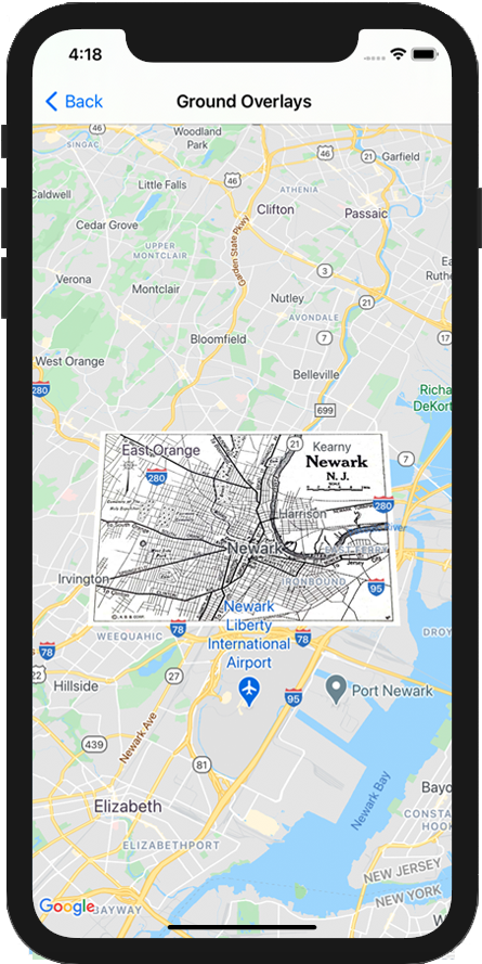
Contoh di bawah menunjukkan cara menambahkan overlay bumi ke objek
GMSMapView yang ada.
Swift
letsouthWest=CLLocationCoordinate2D(latitude:40.712216,longitude:-74.22655)letnorthEast=CLLocationCoordinate2D(latitude:40.773941,longitude:-74.12544)letoverlayBounds=GMSCoordinateBounds(coordinate:southWest,coordinate:northEast)// Image from http://www.lib.utexas.edu/maps/historical/newark_nj_1922.jpgleticon=UIImage(named:"newark_nj_1922")letoverlay=GMSGroundOverlay(bounds:overlayBounds,icon:icon)overlay.bearing=0overlay.map=mapView
Objective-C
CLLocationCoordinate2DsouthWest=CLLocationCoordinate2DMake(40.712216,-74.22655);CLLocationCoordinate2DnorthEast=CLLocationCoordinate2DMake(40.773941,-74.12544);GMSCoordinateBounds*overlayBounds=[[GMSCoordinateBoundsalloc]initWithCoordinate:southWestcoordinate:northEast];// Image from http://www.lib.utexas.edu/maps/historical/newark_nj_1922.jpgUIImage*icon=[UIImageimageNamed:@"newark_nj_1922"];GMSGroundOverlay*overlay=[GMSGroundOverlaygroundOverlayWithBounds:overlayBoundsicon:icon];overlay.bearing=0;overlay.map=mapView;
Menghapus overlay
Anda dapat menghapus overlay bumi dari peta dengan menyetel properti mapGMSGroundOverlay ke nil. Atau, Anda dapat menghapus semua overlay (termasuk overlay bumi yang saat ini ada di peta) dengan memanggil metode GMSMapViewclear.
Swift
mapView.clear()
Objective-C
[mapViewclear];
Jika ingin mengubah overlay bumi setelah menambahkannya ke peta, pastikan Anda tetap mempertahankan objek GMSGroundOverlay. Anda dapat
memodifikasi overlay bumi nanti dengan membuat perubahan pada objek ini.
Anda dapat memproses peristiwa yang terjadi di peta, seperti saat pengguna mengetuk overlay. Untuk memproses peristiwa, Anda harus menerapkan protokol
GMSMapViewDelegate. Lihat
panduan peristiwa dan daftar metode di
GMSMapViewDelegate.
[[["Mudah dipahami","easyToUnderstand","thumb-up"],["Memecahkan masalah saya","solvedMyProblem","thumb-up"],["Lainnya","otherUp","thumb-up"]],[["Informasi yang saya butuhkan tidak ada","missingTheInformationINeed","thumb-down"],["Terlalu rumit/langkahnya terlalu banyak","tooComplicatedTooManySteps","thumb-down"],["Sudah usang","outOfDate","thumb-down"],["Masalah terjemahan","translationIssue","thumb-down"],["Masalah kode / contoh","samplesCodeIssue","thumb-down"],["Lainnya","otherDown","thumb-down"]],["Terakhir diperbarui pada 2025-09-05 UTC."],[[["\u003cp\u003eGround overlays are images fixed to a map, oriented to the Earth's surface, and change orientation with map interactions.\u003c/p\u003e\n"],["\u003cp\u003eTo add a ground overlay, create a \u003ccode\u003eGMSGroundOverlay\u003c/code\u003e object, define its icon, bounds, and optional settings, then set its \u003ccode\u003emap\u003c/code\u003e property.\u003c/p\u003e\n"],["\u003cp\u003eGround overlays can be removed by setting the \u003ccode\u003emap\u003c/code\u003e property to \u003ccode\u003enil\u003c/code\u003e or using the \u003ccode\u003eclear\u003c/code\u003e method on the \u003ccode\u003eGMSMapView\u003c/code\u003e.\u003c/p\u003e\n"],["\u003cp\u003eModifications to existing ground overlays can be made by accessing and updating the \u003ccode\u003eGMSGroundOverlay\u003c/code\u003e object directly.\u003c/p\u003e\n"],["\u003cp\u003eImplement the \u003ccode\u003eGMSMapViewDelegate\u003c/code\u003e protocol to listen to events like user taps on the overlay.\u003c/p\u003e\n"]]],["Ground overlays, images fixed to a map using latitude/longitude, are added by creating a `GMSGroundOverlay` object. This requires setting both the `icon` (an image) and `bounds` (southwest/northeast coordinates). Optionally, set properties like `bearing` and `zoomLevel`. To display, assign the object's `map` property. Overlays are removed by setting `map` to `nil` or using the `clear` method. Modifications require retaining the `GMSGroundOverlay` object and to listen for events, you must implement `GMSMapViewDelegate`.\n"],null,["Select platform: [Android](/maps/documentation/android-sdk/groundoverlay \"View this page for the Android platform docs.\") [iOS](/maps/documentation/ios-sdk/overlays \"View this page for the iOS platform docs.\") [JavaScript](/maps/documentation/javascript/groundoverlays \"View this page for the JavaScript platform docs.\")\n\n\u003cbr /\u003e\n\nGround overlays are overlays on the map that are tied to latitude/longitude\ncoordinates, so they move when you drag or zoom the map.\n\nIntroduction\n\nA ground overlay is an image that is fixed to a map. Unlike\n[markers](/maps/documentation/ios-sdk/marker), ground overlays are oriented against the Earth's surface\nrather than the screen, so rotating, tilting or zooming the map will change\nthe orientation of the image.\n\nTo add a ground overlay, create a\n[`GMSGroundOverlay`](/maps/documentation/ios-sdk/reference/objc/Classes/GMSGroundOverlay)\nobject that defines both an icon and a bounds. Failing to specify either will\ncause the ground overlay to not appear on the map. You can optionally specify\nadditional settings that will affect the positioning of the image on the map.\nOnce you've defined the necessary options, set this object's `map` property to\nadd the overlay.\n\nAdding an overlay\n\n1. Instantiate a new `GMSGroundOverlay` object\n2. Set the `icon` property to an instance of `UIImage`.\n3. Set the `bounds` property to an instance of `GMSCoordinateBounds`. The bounds represent the south west, and north east corners of the image.\n4. Set optional properties, such as `bearing` and `zoomLevel`, as desired.\n5. Set the `map` property - the image appears on the map.\n\nThe below example demonstrates how to add a ground overlay to an existing\n`GMSMapView` object.\n\n\nSwift \n\n```swift\nlet southWest = CLLocationCoordinate2D(latitude: 40.712216, longitude: -74.22655)\nlet northEast = CLLocationCoordinate2D(latitude: 40.773941, longitude: -74.12544)\nlet overlayBounds = GMSCoordinateBounds(coordinate: southWest, coordinate: northEast)\n\n// Image from http://www.lib.utexas.edu/maps/historical/newark_nj_1922.jpg\nlet icon = UIImage(named: \"newark_nj_1922\")\n\nlet overlay = GMSGroundOverlay(bounds: overlayBounds, icon: icon)\noverlay.bearing = 0\noverlay.map = mapView\n \n```\n\nObjective-C \n\n```objective-c\nCLLocationCoordinate2D southWest = CLLocationCoordinate2DMake(40.712216,-74.22655);\nCLLocationCoordinate2D northEast = CLLocationCoordinate2DMake(40.773941,-74.12544);\nGMSCoordinateBounds *overlayBounds = [[GMSCoordinateBounds alloc] initWithCoordinate:southWest\n coordinate:northEast];\n\n// Image from http://www.lib.utexas.edu/maps/historical/newark_nj_1922.jpg\nUIImage *icon = [UIImage imageNamed:@\"newark_nj_1922\"];\nGMSGroundOverlay *overlay = [GMSGroundOverlay groundOverlayWithBounds:overlayBounds icon:icon];\noverlay.bearing = 0;\noverlay.map = mapView;\n \n```\n\n\u003cbr /\u003e\n\nRemoving an overlay\n\nYou can remove a ground overlay from the map by setting your\n`GMSGroundOverlay`'s `map` property to `nil`. Alternately, you can remove all\nof the overlays (including ground overlays currently on the map by calling the\n`GMSMapView` `clear` method.\n\n\nSwift \n\n```swift\nmapView.clear()\n \n```\n\nObjective-C \n\n```objective-c\n[mapView clear];\n \n```\n\n\u003cbr /\u003e\n\nIf you wish to make modifications to a ground overlay after you've added it to\nthe map, ensure that you keep hold of the `GMSGroundOverlay` object. You can\nmodify the ground overlay later by making changes to this object.\n\n\nSwift \n\n```swift\nlet overlay = GMSGroundOverlay(bounds: overlayBounds, icon: icon)\noverlay.bearing = 0\noverlay.map = mapView\n\n// ...\n\noverlay.isTappable = true\n \n```\n\nObjective-C \n\n```objective-c\nGMSGroundOverlay *overlay = [GMSGroundOverlay groundOverlayWithBounds:overlayBounds icon:icon];\noverlay.bearing = 0;\noverlay.map = mapView;\n\n// ...\noverlay.tappable = YES;\n \n```\n\n\u003cbr /\u003e\n\nEvents\n\nYou can listen to events that occur on the map, such as when a user taps an\noverlay. To listen to events, you must implement the\n[`GMSMapViewDelegate`](/maps/documentation/ios-sdk/reference/objc/Protocols/GMSMapViewDelegate) protocol. See the\n[guide to events](/maps/documentation/ios-sdk/events) and the list of methods on the\n[`GMSMapViewDelegate`](/maps/documentation/ios-sdk/reference/objc/Protocols/GMSMapViewDelegate)."]]