Las superposiciones de suelo son superposiciones en el mapa que están vinculadas a coordenadas de latitud y longitud, por lo que se mueven cuando arrastras el mapa o haces zoom.
Introducción
Una superposición de suelo es una imagen que se fija a un mapa. A diferencia de los marcadores, las superposiciones de suelo se orientan respecto de la superficie de la Tierra en lugar de la pantalla, por lo que la orientación de la imagen cambiará al rotar, inclinar o acercar o alejar el mapa.
Para agregar una superposición de tierra, crea un objeto GMSGroundOverlay que defina un ícono y límites. Si no se especifica ninguno de los dos, la superposición de suelo no aparecerá en el mapa. Si lo deseas, puedes especificar otras opciones de configuración que afectarán la posición de la imagen en el mapa.
Una vez que hayas definido las opciones necesarias, establece la propiedad map de este objeto para agregar la superposición.
Cómo agregar una superposición
Crea una instancia de un objeto GMSGroundOverlay nuevo.
Establece la propiedad icon en una instancia de UIImage.
Establece la propiedad bounds en una instancia de GMSCoordinateBounds. Los límites representan las esquinas suroeste y noreste de la imagen.
Configura las propiedades opcionales, como bearing y zoomLevel, según lo desees.
Establece la propiedad map. La imagen aparecerá en el mapa.
En el siguiente ejemplo, se muestra cómo agregar una superposición de suelo a un objeto GMSMapView existente:
Swift
letsouthWest=CLLocationCoordinate2D(latitude:40.712216,longitude:-74.22655)letnorthEast=CLLocationCoordinate2D(latitude:40.773941,longitude:-74.12544)letoverlayBounds=GMSCoordinateBounds(coordinate:southWest,coordinate:northEast)// Image from http://www.lib.utexas.edu/maps/historical/newark_nj_1922.jpgleticon=UIImage(named:"newark_nj_1922")letoverlay=GMSGroundOverlay(bounds:overlayBounds,icon:icon)overlay.bearing=0overlay.map=mapView
Objective-C
CLLocationCoordinate2DsouthWest=CLLocationCoordinate2DMake(40.712216,-74.22655);CLLocationCoordinate2DnorthEast=CLLocationCoordinate2DMake(40.773941,-74.12544);GMSCoordinateBounds*overlayBounds=[[GMSCoordinateBoundsalloc]initWithCoordinate:southWestcoordinate:northEast];// Image from http://www.lib.utexas.edu/maps/historical/newark_nj_1922.jpgUIImage*icon=[UIImageimageNamed:@"newark_nj_1922"];GMSGroundOverlay*overlay=[GMSGroundOverlaygroundOverlayWithBounds:overlayBoundsicon:icon];overlay.bearing=0;overlay.map=mapView;
Cómo quitar una superposición
Para quitar una superposición de suelo del mapa, establece la propiedad map de tu GMSGroundOverlay en nil. Como alternativa, puedes quitar todas las superposiciones (incluidas las de suelo que se encuentran actualmente en el mapa) llamando al método GMSMapViewclear.
Swift
mapView.clear()
Objective-C
[mapViewclear];
Si deseas modificar una superposición de suelo tras agregarla al mapa, asegúrate de conservar el objeto GMSGroundOverlay. Para modificar la superposición en el suelo en otro momento, realiza cambios a este objeto.
Puedes escuchar los eventos que ocurren en el mapa, como cuando un usuario presiona una superposición. Para escuchar eventos, debes implementar el protocolo GMSMapViewDelegate. Consulta la guía de eventos y la lista de métodos en GMSMapViewDelegate.
[[["Fácil de comprender","easyToUnderstand","thumb-up"],["Resolvió mi problema","solvedMyProblem","thumb-up"],["Otro","otherUp","thumb-up"]],[["Falta la información que necesito","missingTheInformationINeed","thumb-down"],["Muy complicado o demasiados pasos","tooComplicatedTooManySteps","thumb-down"],["Desactualizado","outOfDate","thumb-down"],["Problema de traducción","translationIssue","thumb-down"],["Problema con las muestras o los códigos","samplesCodeIssue","thumb-down"],["Otro","otherDown","thumb-down"]],["Última actualización: 2025-08-31 (UTC)"],[[["\u003cp\u003eGround overlays are images fixed to a map, oriented to the Earth's surface, and change orientation with map interactions.\u003c/p\u003e\n"],["\u003cp\u003eTo add a ground overlay, create a \u003ccode\u003eGMSGroundOverlay\u003c/code\u003e object, define its icon, bounds, and optional settings, then set its \u003ccode\u003emap\u003c/code\u003e property.\u003c/p\u003e\n"],["\u003cp\u003eGround overlays can be removed by setting the \u003ccode\u003emap\u003c/code\u003e property to \u003ccode\u003enil\u003c/code\u003e or using the \u003ccode\u003eclear\u003c/code\u003e method on the \u003ccode\u003eGMSMapView\u003c/code\u003e.\u003c/p\u003e\n"],["\u003cp\u003eModifications to existing ground overlays can be made by accessing and updating the \u003ccode\u003eGMSGroundOverlay\u003c/code\u003e object directly.\u003c/p\u003e\n"],["\u003cp\u003eImplement the \u003ccode\u003eGMSMapViewDelegate\u003c/code\u003e protocol to listen to events like user taps on the overlay.\u003c/p\u003e\n"]]],["Ground overlays, images fixed to a map using latitude/longitude, are added by creating a `GMSGroundOverlay` object. This requires setting both the `icon` (an image) and `bounds` (southwest/northeast coordinates). Optionally, set properties like `bearing` and `zoomLevel`. To display, assign the object's `map` property. Overlays are removed by setting `map` to `nil` or using the `clear` method. Modifications require retaining the `GMSGroundOverlay` object and to listen for events, you must implement `GMSMapViewDelegate`.\n"],null,["Select platform: [Android](/maps/documentation/android-sdk/groundoverlay \"View this page for the Android platform docs.\") [iOS](/maps/documentation/ios-sdk/overlays \"View this page for the iOS platform docs.\") [JavaScript](/maps/documentation/javascript/groundoverlays \"View this page for the JavaScript platform docs.\")\n\n\u003cbr /\u003e\n\nGround overlays are overlays on the map that are tied to latitude/longitude\ncoordinates, so they move when you drag or zoom the map.\n\nIntroduction\n\nA ground overlay is an image that is fixed to a map. Unlike\n[markers](/maps/documentation/ios-sdk/marker), ground overlays are oriented against the Earth's surface\nrather than the screen, so rotating, tilting or zooming the map will change\nthe orientation of the image.\n\nTo add a ground overlay, create a\n[`GMSGroundOverlay`](/maps/documentation/ios-sdk/reference/objc/Classes/GMSGroundOverlay)\nobject that defines both an icon and a bounds. Failing to specify either will\ncause the ground overlay to not appear on the map. You can optionally specify\nadditional settings that will affect the positioning of the image on the map.\nOnce you've defined the necessary options, set this object's `map` property to\nadd the overlay.\n\nAdding an overlay\n\n1. Instantiate a new `GMSGroundOverlay` object\n2. Set the `icon` property to an instance of `UIImage`.\n3. Set the `bounds` property to an instance of `GMSCoordinateBounds`. The bounds represent the south west, and north east corners of the image.\n4. Set optional properties, such as `bearing` and `zoomLevel`, as desired.\n5. Set the `map` property - the image appears on the map.\n\nThe below example demonstrates how to add a ground overlay to an existing\n`GMSMapView` object.\n\n\nSwift \n\n```swift\n
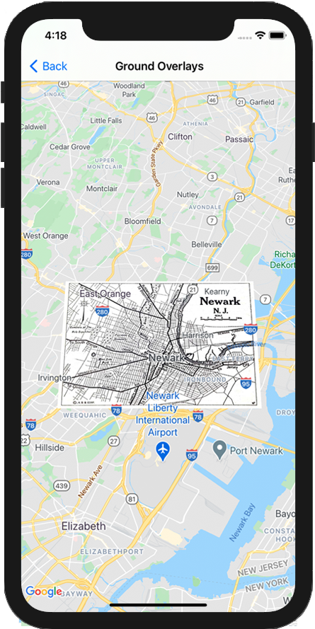
let southWest = CLLocationCoordinate2D(latitude: 40.712216, longitude: -74.22655)\nlet northEast = CLLocationCoordinate2D(latitude: 40.773941, longitude: -74.12544)\nlet overlayBounds = GMSCoordinateBounds(coordinate: southWest, coordinate: northEast)\n\n// Image from http://www.lib.utexas.edu/maps/historical/newark_nj_1922.jpg\nlet icon = UIImage(named: \"newark_nj_1922\")\n\nlet overlay = GMSGroundOverlay(bounds: overlayBounds, icon: icon)\noverlay.bearing = 0\noverlay.map = mapView\n \n```\n\nObjective-C \n\n```objective-c\nCLLocationCoordinate2D southWest = CLLocationCoordinate2DMake(40.712216,-74.22655);\nCLLocationCoordinate2D northEast = CLLocationCoordinate2DMake(40.773941,-74.12544);\nGMSCoordinateBounds *overlayBounds = [[GMSCoordinateBounds alloc] initWithCoordinate:southWest\n coordinate:northEast];\n\n// Image from http://www.lib.utexas.edu/maps/historical/newark_nj_1922.jpg\nUIImage *icon = [UIImage imageNamed:@\"newark_nj_1922\"];\nGMSGroundOverlay *overlay = [GMSGroundOverlay groundOverlayWithBounds:overlayBounds icon:icon];\noverlay.bearing = 0;\noverlay.map = mapView;\n \n```\n\n\u003cbr /\u003e\n\nRemoving an overlay\n\nYou can remove a ground overlay from the map by setting your\n`GMSGroundOverlay`'s `map` property to `nil`. Alternately, you can remove all\nof the overlays (including ground overlays currently on the map by calling the\n`GMSMapView` `clear` method.\n\n\nSwift \n\n```swift\nmapView.clear()\n \n```\n\nObjective-C \n\n```objective-c\n[mapView clear];\n \n```\n\n\u003cbr /\u003e\n\nIf you wish to make modifications to a ground overlay after you've added it to\nthe map, ensure that you keep hold of the `GMSGroundOverlay` object. You can\nmodify the ground overlay later by making changes to this object.\n\n\nSwift \n\n```swift\nlet overlay = GMSGroundOverlay(bounds: overlayBounds, icon: icon)\noverlay.bearing = 0\noverlay.map = mapView\n\n// ...\n\noverlay.isTappable = true\n \n```\n\nObjective-C \n\n```objective-c\nGMSGroundOverlay *overlay = [GMSGroundOverlay groundOverlayWithBounds:overlayBounds icon:icon];\noverlay.bearing = 0;\noverlay.map = mapView;\n\n// ...\noverlay.tappable = YES;\n \n```\n\n\u003cbr /\u003e\n\nEvents\n\nYou can listen to events that occur on the map, such as when a user taps an\noverlay. To listen to events, you must implement the\n[`GMSMapViewDelegate`](/maps/documentation/ios-sdk/reference/objc/Protocols/GMSMapViewDelegate) protocol. See the\n[guide to events](/maps/documentation/ios-sdk/events) and the list of methods on the\n[`GMSMapViewDelegate`](/maps/documentation/ios-sdk/reference/objc/Protocols/GMSMapViewDelegate)."]]