
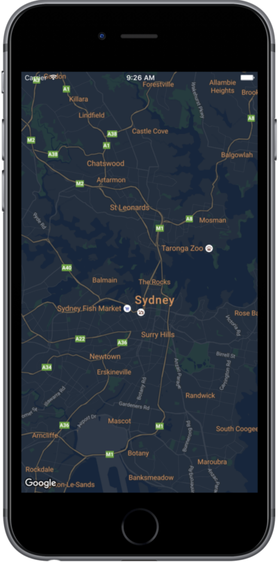
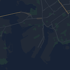
本頁提供快速指南,以夜間模式為例,說明如何設定地圖樣式。
總覽
您可以利用樣式選項,自訂標準 Google 地圖樣式的呈現方式,以不同的視覺效果顯示道路、公園、商家及其他搜尋點等地圖項目。這表示您可以凸顯地圖的特定元件,也能依自己的應用程式樣式,設定地圖元件。
樣式僅適用 kGMSTypeNormal 地圖類型。
將樣式套用至地圖
如要將自訂地圖樣式套用至地圖,請呼叫 GMSMapStyle(...) 建立 GMSMapStyle 例項,並傳遞本機 JSON 檔案的網址,或包含樣式定義的 JSON 字串。將 GMSMapStyle 執行個體指派給地圖的 mapStyle 屬性。
使用 JSON 檔案
以下範例顯示如何呼叫 GMSMapStyle(...),並傳遞本機檔案的網址:
Swift
import GoogleMaps

class MapStyling: UIViewController {

  // Set the status bar style to complement night-mode.
  override var preferredStatusBarStyle: UIStatusBarStyle {
    return .lightContent
  }

  override func loadView() {
    let camera = GMSCameraPosition.camera(withLatitude: -33.86, longitude: 151.20, zoom: 14.0)
    let mapView = GMSMapView.map(withFrame: CGRect.zero, camera: camera)

    do {
      // Set the map style by passing the URL of the local file.
      if let styleURL = Bundle.main.url(forResource: "style", withExtension: "json") {
        mapView.mapStyle = try GMSMapStyle(contentsOfFileURL: styleURL)
      } else {
        NSLog("Unable to find style.json")
      }
    } catch {
      NSLog("One or more of the map styles failed to load. \(error)")
    }

    self.view = mapView
  }
}
Objective-C
#import "MapStyling.h"
@import GoogleMaps;

@interface MapStyling ()

@end

@implementation MapStyling

// Set the status bar style to complement night-mode.
- (UIStatusBarStyle)preferredStatusBarStyle {
  return UIStatusBarStyleLightContent;
}

- (void)loadView {
  GMSCameraPosition *camera = [GMSCameraPosition cameraWithLatitude:-33.86
                                                          longitude:151.20
                                                               zoom:12];
  GMSMapView *mapView = [GMSMapView mapWithFrame:CGRectZero camera:camera];
  mapView.myLocationEnabled = YES;

  NSBundle *mainBundle = [NSBundle mainBundle];
  NSURL *styleUrl = [mainBundle URLForResource:@"style" withExtension:@"json"];
  NSError *error;

  // Set the map style by passing the URL for style.json.
  GMSMapStyle *style = [GMSMapStyle styleWithContentsOfFileURL:styleUrl error:&error];

  if (!style) {
    NSLog(@"The style definition could not be loaded: %@", error);
  }

  mapView.mapStyle = style;
  self.view = mapView;
}

@end
如要定義樣式選項,請在專案中新增名為 style.json 的檔案,然後貼上下列夜間模式樣式的 JSON 樣式宣告:
使用字串資源
以下範例說明如何呼叫 GMSMapStyle(...) 並傳遞字串資源:
Swift
class MapStylingStringResource: UIViewController {

  let MapStyle = "JSON_STYLE_GOES_HERE"

  // Set the status bar style to complement night-mode.
  override var preferredStatusBarStyle: UIStatusBarStyle {
    return .lightContent
  }

  override func loadView() {
    let camera = GMSCameraPosition.camera(withLatitude: -33.86, longitude: 151.20, zoom: 14.0)
    let mapView = GMSMapView.map(withFrame: CGRect.zero, camera: camera)

    do {
      // Set the map style by passing a valid JSON string.
      mapView.mapStyle = try GMSMapStyle(jsonString: MapStyle)
    } catch {
      NSLog("One or more of the map styles failed to load. \(error)")
    }

    self.view = mapView
  }
}
Objective-C
@implementation MapStylingStringResource

// Paste the JSON string to use.
static NSString *const kMapStyle = @"JSON_STYLE_GOES_HERE";

// Set the status bar style to complement night-mode.
- (UIStatusBarStyle)preferredStatusBarStyle {
  return UIStatusBarStyleLightContent;
}

- (void)loadView {
  GMSCameraPosition *camera = [GMSCameraPosition cameraWithLatitude:-33.86
                                                          longitude:151.20
                                                               zoom:12];
  GMSMapView *mapView = [GMSMapView mapWithFrame:CGRectZero camera:camera];
  mapView.myLocationEnabled = YES;

  NSError *error;

  // Set the map style by passing a valid JSON string.
  GMSMapStyle *style = [GMSMapStyle styleWithJSONString:kMapStyle error:&error];

  if (!style) {
    NSLog(@"The style definition could not be loaded: %@", error);
  }

  mapView.mapStyle = style;
  self.view = mapView;
}

@end
如要定義樣式選項,請將下列樣式字串貼到 kMapStyle 變數的值中:
JSON 樣式宣告
樣式化地圖使用以下兩種概念,將顏色和其他樣式變更套用至地圖:
- 選取器程式碼是用來指定可在地圖上設定樣式的地理元件,包括道路、公園、水域等等,以及這些地點的標籤。選取器程式碼包含「地圖項目」和「元素」,分別以
featureType和elementType屬性表示。 - 樣式函數是可套用至地圖元素的顏色和能見度屬性;這類屬性會透過色調、色彩及亮度/Gamma 值搭配,定義顯示的顏色。
如需 JSON 樣式選項詳細說明,請參閱樣式參考資料。
地圖平台樣式精靈


使用地圖平台樣式精靈快速產生 JSON 樣式物件。Maps SDK for iOS 支援與 Maps JavaScript API 相同的樣式宣告。
完整程式碼範例
GitHub 上的 ApiDemos 存放區包含說明如何使用樣式設定的範例。
下一步
瞭解如何透過樣式設定在地圖上隱藏地圖項目。