
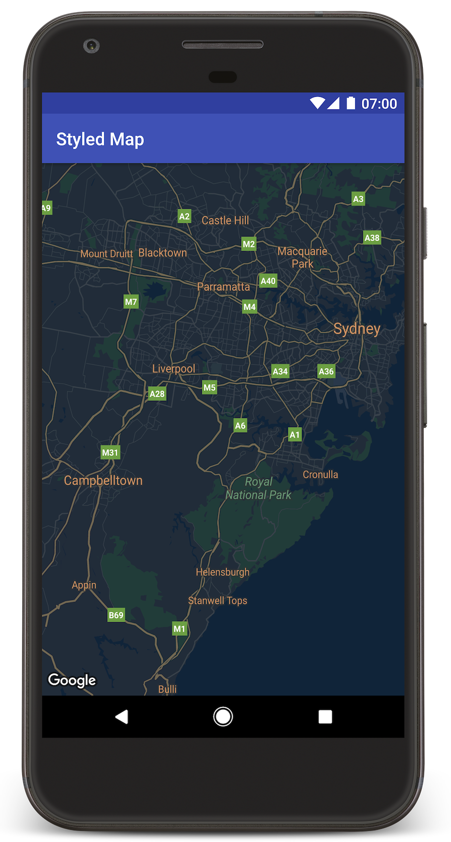
本教學課程以「夜間模式」為自訂樣式範例,說明如何在 Android 應用程式中加入包含自訂樣式的地圖。
您可以利用樣式選項來自訂標準 Google 地圖樣式的呈現方式,以不同的視覺效果顯示道路、公園、商家及其他搜尋點等地圖項目。這表示您可以凸顯地圖的特定元件,也能依自己的應用程式樣式,設定地圖元件。
樣式僅適用 normal 地圖類型,並不影響室內地圖。
取得程式碼
從 GitHub 複製或下載 Google Maps Android API 第 2 版範例存放區。
設定開發專案
如要在 Android Studio 中建立教學課程專案,請按照下列步驟操作。
- 下載並安裝 Android Studio。
- 將 Google Play 服務套件加入 Android Studio。
- 如果您尚未複製或下載 Google Maps Android API 第 2 版範例存放區,請先複製或下載。
匯入教學課程專案:
- 在 Android Studio 中,選取「File」(檔案) >「New」(新增) >「Import Project」(匯入專案)。
- 下載完成後,請前往您儲存 Google Maps Android API 第 2 版範例存放區的位置。
- 在這個位置找到 StyledMap 專案:
PATH-TO-SAVED-REPO/android-samples/tutorials/StyledMap - 選取專案目錄,然後按一下「OK」(確定)。Android Studio 現在會使用 Gradle 建構工具來建立您的專案。
取得 API 金鑰並啟用必要的 API
如想完成本教學課程,請取得具備 Maps SDK for Android 使用授權的 Google API 金鑰。
點選下方按鈕即可取得金鑰並啟用 API。
詳情請參閱取得 API 金鑰指南。
在應用程式中加入 API 金鑰
- 編輯專案的
gradle.properties檔案。 將 API 金鑰貼到
GOOGLE_MAPS_API_KEY屬性值。在您建構應用程式時,Gradle 會將 API 金鑰複製到應用程式的 Android 資訊清單中。GOOGLE_MAPS_API_KEY=PASTE-YOUR-API-KEY-HERE
建構並執行應用程式
- 將 Android 裝置連接到電腦。按照操作說明為 Android 裝置啟用開發人員選項,並將系統設定為偵測裝置 (您也可以使用 Android 虛擬裝置管理工具 (AVD Manager) 來設定虛擬裝置。選擇模擬器時,請務必挑選包含 Google API 的映像檔。詳情請參閱入門指南)。
- 在 Android Studio 中,按一下「Run」(執行) 選單選項 (或播放按鈕圖示), 然後按照系統提示選擇裝置。
Android Studio 會叫用 Gradle 來建構應用程式,然後在裝置或模擬器上執行應用程式。您應該會看到一個顏色較深的地圖 (夜間模式),類似本頁的圖片。
疑難排解:
- 如未看到地圖,請檢查您是否已按照上述步驟取得 API 金鑰,並加到應用程式。在 Android Studio 的 Android Monitor 查看記錄檔,檢視是否有關於 API 金鑰的錯誤訊息。
- 使用 Android Studio 偵錯工具查看記錄檔並為應用程式偵錯。
瞭解程式碼
本段將說明 StyledMap 應用程式最重要的部分,協助您瞭解如何建構類似的應用程式。
新增包含 JSON 樣式物件的資源
在開發專案中新增資源,包含 JSON 格式的樣式宣告。您可以使用原始資源或字串,如下方範例所示。
原始資源
在 /res/raw/style_json.json 中定義原始資源,包含夜間模式樣式的 JSON 樣式宣告:
字串資源
在 /res/values/style_strings.xml 中定義字串資源,包含夜間模式樣式的 JSON 樣式宣告。本教學課程使用 style_json 這個字串名稱。在這個檔案中,請使用反斜線逸出引號:
將 JSON 樣式物件傳遞至地圖
設定地圖樣式時,請呼叫 GoogleMap.setMapStyle(),並傳遞包含 JSON 格式樣式宣告的 MapStyleOptions 物件。
原始資源
下列程式碼範例假設您的專案含有名為 style_json 的原始資源:
// Copyright 2020 Google LLC
//
// Licensed under the Apache License, Version 2.0 (the "License");
// you may not use this file except in compliance with the License.
// You may obtain a copy of the License at
//
//      http://www.apache.org/licenses/LICENSE-2.0
//
// Unless required by applicable law or agreed to in writing, software
// distributed under the License is distributed on an "AS IS" BASIS,
// WITHOUT WARRANTIES OR CONDITIONS OF ANY KIND, either express or implied.
// See the License for the specific language governing permissions and
// limitations under the License.

package com.example.styledmap;

import android.content.res.Resources;
import android.os.Bundle;
import android.util.Log;
import androidx.appcompat.app.AppCompatActivity;

import com.google.android.gms.maps.CameraUpdateFactory;
import com.google.android.gms.maps.GoogleMap;
import com.google.android.gms.maps.OnMapReadyCallback;
import com.google.android.gms.maps.SupportMapFragment;
import com.google.android.gms.maps.model.LatLng;
import com.google.android.gms.maps.model.MapStyleOptions;

/**
 * A styled map using JSON styles from a raw resource.
 */
public class MapsActivityRaw extends AppCompatActivity
        implements OnMapReadyCallback {

    private static final String TAG = MapsActivityRaw.class.getSimpleName();

    @Override
    protected void onCreate(Bundle savedInstanceState) {
        super.onCreate(savedInstanceState);
        // Retrieve the content view that renders the map.
        setContentView(R.layout.activity_maps_raw);

        // Get the SupportMapFragment and register for the callback
        // when the map is ready for use.
        SupportMapFragment mapFragment =
                (SupportMapFragment) getSupportFragmentManager()
                        .findFragmentById(R.id.map);
        mapFragment.getMapAsync(this);
    }

    /**
     * Manipulates the map when it's available.
     * The API invokes this callback when the map is ready for use.
     */
    @Override
    public void onMapReady(GoogleMap googleMap) {

        try {
            // Customise the styling of the base map using a JSON object defined
            // in a raw resource file.
            boolean success = googleMap.setMapStyle(
                    MapStyleOptions.loadRawResourceStyle(
                            this, R.raw.style_json));

            if (!success) {
                Log.e(TAG, "Style parsing failed.");
            }
        } catch (Resources.NotFoundException e) {
            Log.e(TAG, "Can't find style. Error: ", e);
        }
        // Position the map's camera near Sydney, Australia.
        googleMap.moveCamera(CameraUpdateFactory.newLatLng(new LatLng(-34, 151)));
    }
}
版面配置 (activity_maps_raw.xml) 如下所示:
字串資源
下列程式碼範例假設您的專案含有名為 style_json 的字串資源:
package com.example.styledmap;

import android.os.Bundle;
import android.support.v7.app.AppCompatActivity;
import android.util.Log;

import com.google.android.gms.maps.CameraUpdateFactory;
import com.google.android.gms.maps.GoogleMap;
import com.google.android.gms.maps.OnMapReadyCallback;
import com.google.android.gms.maps.SupportMapFragment;
import com.google.android.gms.maps.model.LatLng;
import com.google.android.gms.maps.model.MapStyleOptions;

/**
 * A styled map using JSON styles from a string resource.
 */
public class MapsActivityString extends AppCompatActivity
        implements OnMapReadyCallback {

    private static final String TAG = MapsActivityString.class.getSimpleName();

    @Override
    protected void onCreate(Bundle savedInstanceState) {
        super.onCreate(savedInstanceState);
        // Retrieve the content view that renders the map.
        setContentView(R.layout.activity_maps_string);

        // Get the SupportMapFragment and register for the callback
        // when the map is ready for use.
        SupportMapFragment mapFragment =
                (SupportMapFragment) getSupportFragmentManager()
                        .findFragmentById(R.id.map);
        mapFragment.getMapAsync(this);
    }

    /**
     * Manipulates the map when it's available.
     * The API invokes this callback when the map is ready for use.
     */
    @Override
    public void onMapReady(GoogleMap googleMap) {

        // Customise the styling of the base map using a JSON object defined
        // in a string resource file. First create a MapStyleOptions object
        // from the JSON styles string, then pass this to the setMapStyle
        // method of the GoogleMap object.
        boolean success = googleMap.setMapStyle(new MapStyleOptions(getResources()
                .getString(R.string.style_json)));

        if (!success) {
            Log.e(TAG, "Style parsing failed.");
        }
        // Position the map's camera near Sydney, Australia.
        googleMap.moveCamera(CameraUpdateFactory.newLatLng(new LatLng(-34, 151)));
    }
}
版面配置 (activity_maps_string.xml) 如下所示:
其他 JSON 樣式宣告相關資訊
樣式化地圖使用以下兩種概念,將顏色和其他樣式變更套用至地圖:
- 選取器程式碼是用來指定可在地圖上設定樣式的地理元件,包括道路、公園、水域等等,以及這些地點的標籤。選取器程式碼包含「地圖項目」和「元素」,分別以
featureType和elementType屬性表示。 - 樣式函數是可套用至地圖元素的顏色和能見度屬性;這類屬性會透過色調、色彩及亮度/Gamma 值搭配,定義顯示的顏色。
如需 JSON 樣式選項詳細說明,請參閱樣式參考資料。
地圖平台樣式精靈


使用地圖平台樣式精靈快速產生 JSON 樣式物件。Maps SDK for Android 支援與 Maps JavaScript API 相同的樣式宣告。
後續步驟
瞭解如何透過樣式設定在地圖上隱藏地圖項目。