
หากต้องการใช้การจัดรูปแบบตามข้อมูลที่ระบุขอบเขต คุณต้องสร้างรหัสแผนที่ ถัดไปคุณต้องสร้างรูปแบบแผนที่ใหม่ เลือกเลเยอร์องค์ประกอบขอบเขตที่จำเป็น และเชื่อมโยงรูปแบบกับรหัสแผนที่
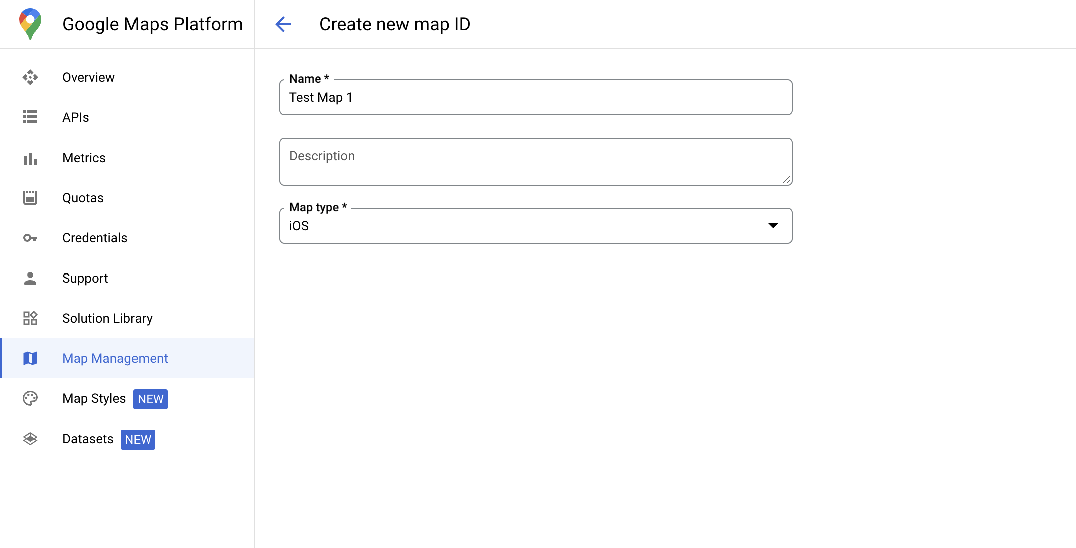
สร้างรหัสแผนที่
mapID คือตัวระบุที่ไม่ซ้ำกันซึ่งแสดงถึงอินสแตนซ์เดียวของ Google Map คุณสร้างรหัสแผนที่และอัปเดตรูปแบบที่เชื่อมโยงกับรหัสแผนที่ได้ทุกเมื่อในคอนโซล Google Cloud
สร้างรูปแบบแผนที่ใหม่
หากต้องการสร้างรูปแบบแผนที่ใหม่ ให้ทำตามวิธีการในจัดการรูปแบบแผนที่เพื่อสร้างรูปแบบ เมื่อเสร็จแล้ว ให้เชื่อมโยงรูปแบบกับรหัสแผนที่ที่สร้างขึ้นใหม่
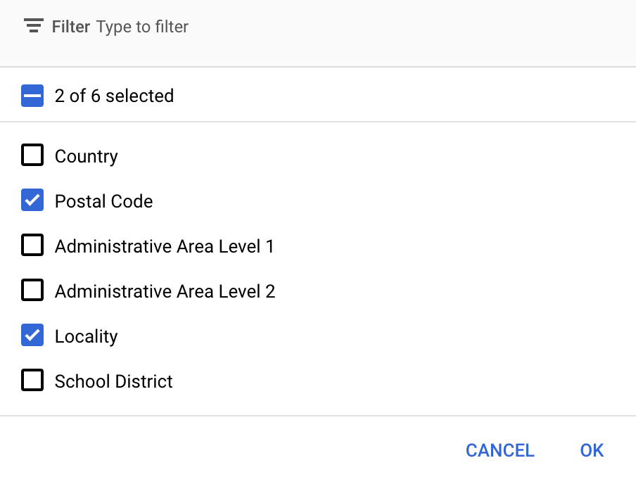
เลือกเลเยอร์องค์ประกอบ
คุณเลือกเลเยอร์ฟีเจอร์ที่จะแสดงได้ในคอนโซล Google Cloud ซึ่งจะเป็นตัวกำหนดขอบเขตประเภทใดที่จะปรากฏบนแผนที่ (เช่น ท้องถิ่น รัฐ และอื่นๆ)
จัดการเลเยอร์ฟีเจอร์
ในคอนโซล Google Cloud ให้ไปที่หน้าสไตล์แผนที่
เลือกโปรเจ็กต์หากได้รับข้อความแจ้ง
เลือกรูปแบบแผนที่
คลิกเมนูแบบเลื่อนลงเลเยอร์องค์ประกอบเพื่อเพิ่มหรือนำเลเยอร์ออก
คลิกบันทึกเพื่อบันทึกการเปลี่ยนแปลงและทำให้แผนที่พร้อมใช้งาน
อัปเดตโค้ดการเริ่มต้นแผนที่
ขั้นตอนนี้กำหนดให้ต้องเชื่อมโยงรหัสแผนที่กับรูปแบบที่เปิดใช้เลเยอร์ฟีเจอร์อย่างน้อย 1 เลเยอร์ หากต้องการยืนยันว่ารหัสแผนที่ได้รับการตั้งค่าอย่างถูกต้องในคอนโซลระบบคลาวด์ ให้ตรวจสอบวิธีกำหนดค่าในส่วนการจัดการแผนที่
Swift
// A map ID using a style with one or more feature layers enabled

let mapID = GMSMapID(identifier: "YOUR_MAP_ID")
let mapView = GMSMapView(frame: .zero, mapID: mapID, camera: GMSCameraPosition(latitude: 40, longitude: -80, zoom: 7))
Objective-C
// A map ID using a style with one or more feature layers enabled

GMSMapID *mapID = [GMSMapID mapIDWithIdentifier:@"MAP_ID"];
GMSMapView *mapView = [GMSMapView mapWithFrame:CGRectZero mapID:mapID camera:[GMSCameraPosition cameraWithLatitude:40 longitude:-80 zoom:7]];
เพิ่มเลเยอร์องค์ประกอบลงในแผนที่
หากต้องการอ้างอิงเลเยอร์องค์ประกอบในแผนที่ ให้เรียกใช้ mapView.featureLayer(of:) เมื่อแผนที่เริ่มต้น
Swift
let layer = mapView.featureLayer(of: .locality)
Objective-C
GMSFeatureLayer*layer = [mapView featureLayerOfFeatureType:GMSFeatureTypeLocality];
ตรวจสอบความสามารถของแผนที่
การจัดสไตล์ตามข้อมูลที่ขับเคลื่อนขอบเขตต้องใช้ความสามารถที่เปิดใช้ในคอนโซล Google Cloud และเชื่อมโยงกับรหัสแผนที่ เนื่องจากรหัสแผนที่อาจมีการเปลี่ยนแปลง คุณจึงเรียกใช้ mapView.mapCapabilities ใน GMSMapView เพื่อยืนยันว่าความสามารถบางอย่าง (เช่น การจัดสไตล์ตามข้อมูล) พร้อมใช้งานหรือไม่ก่อนที่จะเรียกใช้
นอกจากนี้ คุณยังตรวจหาการเปลี่ยนแปลงในความสามารถของแผนที่ได้โดยสมัครรับอีเมลจาก GMSViewDelegate ตัวอย่างนี้แสดงวิธีใช้โปรโตคอลเพื่อตรวจสอบข้อกําหนดการจัดสไตล์ตามข้อมูล
Swift
class SampleViewController: UIViewController {

  private lazy var mapView: GMSMapView = GMSMapView(frame: .zero, mapID: GMSMapID(identifier: "YOUR_MAP_ID"), camera: GMSCameraPosition(latitude: 40, longitude: -80, zoom: 7))

  override func loadView() {
    self.view = mapView
    mapView.delegate = self
  }
}

extension SampleViewController: GMSMapViewDelegate {
  func mapView(_ mapView: GMSMapView, didChange mapCapabilities: GMSMapCapabilityFlags) {
    if (!mapCapabilities.contains(.dataDrivenStyling)) {
      // Data-driven styling is *not* available, add a fallback.
      // Existing feature layers are also unavailable.
    }
  }
}
Objective-C
@interface SampleViewController: UIViewController <GMSMapViewDelegate>
@end

@implementation SampleViewController
- (void)loadView {
  GMSMapView *mapView = [GMSMapView mapWithFrame:CGRectZero mapID:[GMSMapID mapIDWithIdentifier:@"MAP_ID"] camera:[GMSCameraPosition cameraWithLatitude:40 longitude:-80 zoom:7]];
  mapView.delegete = self;
  self.view = mapView;
}

- (void)mapView:(GMSMapView *)mapView didChangeMapCapabilities:(GMSMapCapabilityFlags)mapCapabilities {
  if (!(mapCapabilities & GMSMapCapabilityFlagsDataDrivenStyling)) {
    // Data-driven styling is *not* available, add a fallback.
    // Existing feature layers are also unavailable.
  }
}
@end