
Page Summary
-
The Map Tiles API provides access to Google's 2D and photorealistic 3D Tiles for building custom map experiences.
-
Use the Map Tiles API to create immersive visualizations, build maps without JavaScript or Mobile SDKs, and access extensive Street View metadata.
-
Choose from Roadmap, Satellite, Terrain, Street View, and Photorealistic 3D map themes for your application.
-
Follow the provided steps to set up your Google Cloud project, get an API key and session token, and request desired map tiles.
-
Photorealistic 3D Tiles can be accessed by specifying a root tileset URL to a compatible 3D Tiles renderer.
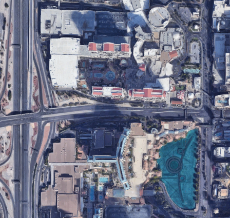 The Map Tiles API gives you direct access to Google's 2D
Tiles and Photorealistic 3D Tiles. 2D Tiles are image files that depict the
world divided into an indexed grid. Like 2D Tiles, 3D Tiles are image
files, but they contain photorealistic imagery of buildings, monuments, and
other POI, which you have to zoom in to see. You can use 2D and 3D Tiles to
build a Google Maps-based immersive experience into your own application.
The Map Tiles API gives you direct access to Google's 2D
Tiles and Photorealistic 3D Tiles. 2D Tiles are image files that depict the
world divided into an indexed grid. Like 2D Tiles, 3D Tiles are image
files, but they contain photorealistic imagery of buildings, monuments, and
other POI, which you have to zoom in to see. You can use 2D and 3D Tiles to
build a Google Maps-based immersive experience into your own application.
Why use the Map Tiles API
Map Tiles API is for Google customers who:
Want to build maps experiences without using JavaScript or Mobile SDKs.
On the desktop, with non-web-based custom apps.
For custom hardware and other tools that need a map.
For navigation systems for automotive and aviation.
Want more metadata for Street View than is provided by the Street View Service or Static Street View API.
Want to create highly customized and immersive visualizations in 2D and 3D.
Available Map Tiles
The following thematic Map Tiles are served through the Map Tiles API. For coverage info, review the Google Maps Platform Coverage Details.
| Map Theme | Description |
|---|---|
| Roadmap | The standard Google Maps basemap tiles + overlay data (with roads, buildings, points of interest, and political boundaries) |
| Satellite | Satellite and aerial imagery |
| Terrain | A hillshade and contour map that shows natural features such as vegetation |
| Street View | Street View panoramas with metadata |
| Photorealistic 3D | A 3D textured mesh with satellite and aerial imagery |
How to use the Map Tiles API
2D Tiles
| 1 | Review the Google Maps Platform Terms of Service | For more information, see the Google Maps Platform Terms of Service and Map Tiles API Policies. |
| 2 | Get set up | Start with Set up your Google Cloud project and complete the instructions that follow. |
| 3 | Get an API key | Create and secure an API key. For more information, see Use API Keys. |
| 4 | Get a session token | Retrieve a session token,
specifying the mapType,
and other options for the session. |
| 5 | Request 2D Map Tiles | Use your API key and session token to request a map tile, get a panorama ID, or get Street View metadata. If you want to request Street View panoramas, then see Street View Tiles for details. |
| 6 | Retrieve viewport information | For basemap, satellite, and terrain tiles, you can retrieve viewport information to get details about the displayed tiles. Viewport requests tell you which regions have imagery, and at what zoom levels, because not all regions support the maximum zoom level of 22. |
Photorealistic 3D Tiles
| 1 | Review the Google Maps Platform Terms of Service | For more information, see the Google Maps Platform Terms of Service and Map Tiles API Policies. |
| 2 | Get set up | Start with Set up your Google Cloud project and complete the instructions that follow. |
| 3 | Get an API key | Create and secure an API key. For more information, see Use API Keys. |
| 4 | Request 3D Photorealistic Tiles | Once you have your API key, you can begin accessing photorealistic tiles by specifying a root tileset URL to a 3D Tiles renderer of your choice. For more information, see Getting 3D tiles |