簡介
這個解決方案是多功能工具,可供記者、旅客和愛好者將敘事內容融入地理景觀。這項服務提供引人入勝的平台,可使用 Google 地圖平台的擬真 3D 圖塊,生動呈現故事內容。無論您是想透過地理背景傳達敘事的記者,還是想記錄冒險歷程的旅人,這個解決方案都能提供簡單易用的介面,協助您分享故事。
目的
3D 故事述說解決方案整合地理資訊,可望提升故事的傳達效果。這項數位故事述說工具可供創作者運用 Google 地圖平台擬真 3D 圖塊,製作身歷其境的互動式敘事內容。目的是要縮短說故事與地理位置之間的差距,為使用者提供引人入勝的體驗。
目標用途
1. 新聞學:
記者可以使用 3D 敘事解決方案,透過位置資訊相關內容提升報導品質。在特定地理位置設定中嵌入敘事內容,可增加新聞文章的深度和真實性,使其更具影響力且引人入勝。
2. 旅行文件:
旅客可以透過精美的視覺化方式記錄旅程。使用者可加入附有地理標記的章節,製作互動式旅遊日誌,不僅能分享體驗,還能提供冒險歷程的空間視角。
3. 教育故事:
教育工作者可以運用這個平台打造沉浸式學習體驗。教育工作者可以透過地理環境,講述歷史事件、科學現象或文化故事,加深學生的理解和參與度。
開始使用:
啟用
主要功能
可設定性:這項解決方案提供可設定的 JSON 結構,使用者可自訂說故事體驗。無論是使用管理應用程式中的直覺式 UI,還是直接編輯 JSON,都能輕鬆自訂設定。
互動式章節:深入瞭解各個故事章節的詳細內容,每個章節都提供獨特的文字內容、媒體元素 (圖片、GIF 或影片) 和地理座標。
動態攝影機控制:透過動態攝影機選項,掌控敘事流程。創作者可透過位置、俯仰角和滾轉角設定精確構圖,提供身歷其境的觀看體驗。
代管式試用版:無須在本機安裝,即可探索各項功能。透過代管的試用版,您可以一窺這項解決方案的敘事潛力。
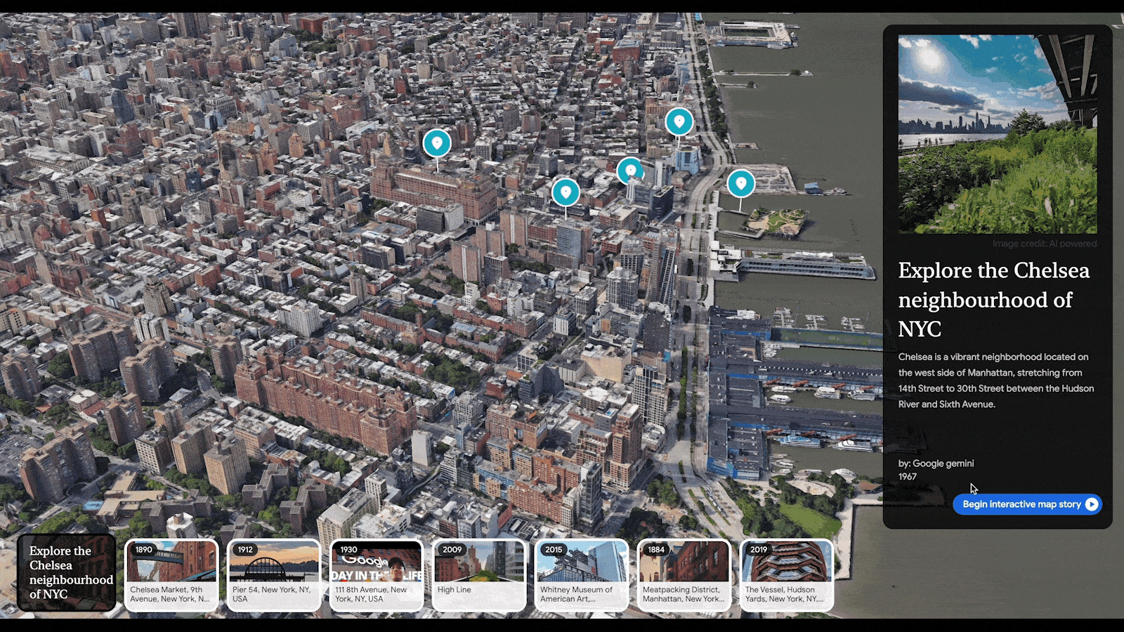
使用應用程式
啟動應用程式後,右側的故事面板會成為你的指南。這是你探索特定故事的中心。導覽方式如下:
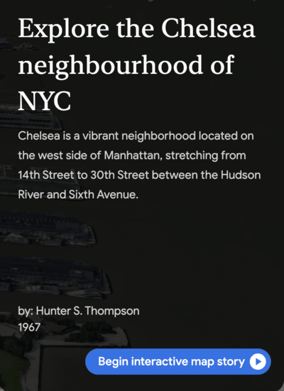
開始故事:按一下粗體的「開始互動式故事」按鈕,即可開始互動式體驗。
自動幻燈片模式:按下播放按鈕即可進入幻燈片模式, 順暢瀏覽故事的每個章節。
瀏覽不同章節:使用導覽箭頭以自己的步調探索故事,在各章節之間來回移動。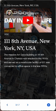
跳至特定章節:故事資訊卡提供捷徑,點選資訊卡即可立即載入該章節。
豐富多媒體:探索充滿吸引人圖片、有趣的 GIF 和嵌入式 YouTube 影片的章節。按一下影片中的播放按鈕,即可直接在精選故事面板中觀看影片。
重要元件
應用程式分為兩個不同的應用程式,分別是:
- 管理應用程式
- 試用版應用程式
下圖概略說明這兩個應用程式的差異和關聯性:
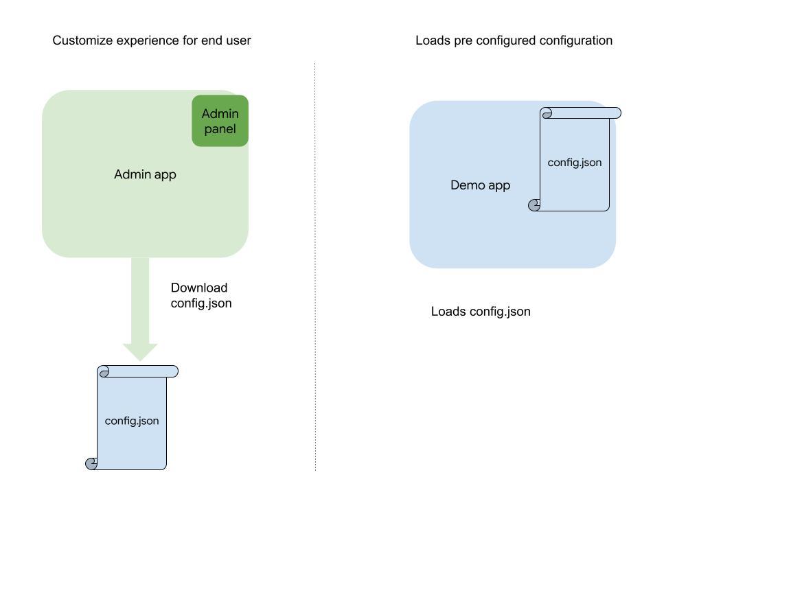
試用版應用程式:
這是最終的應用程式,使用者可透過這個應用程式載入您在管理應用程式中建立的設定。在這個沉浸式 3D 環境中,使用者可以探索所選區域,並發掘您標示的興趣點。
使用 Admin 應用程式自訂外觀和風格後,即可下載設定,並從原始碼執行自訂應用程式。
管理員應用程式:
這個應用程式提供簡單易用的介面,可供你自訂 3D 體驗: 如要進一步瞭解如何使用管理員應用程式建立及自訂故事,請參閱這篇文章。
必要條件
Google API 金鑰:您必須使用已啟用下列 API 的 Google Cloud API 金鑰:
網路伺服器:您可以透過下列任一方式代管應用程式:
- 本機網路伺服器 (例如使用 Node.js、http-server)
- 網站代管服務 (應用程式隨附 Dockerfile)
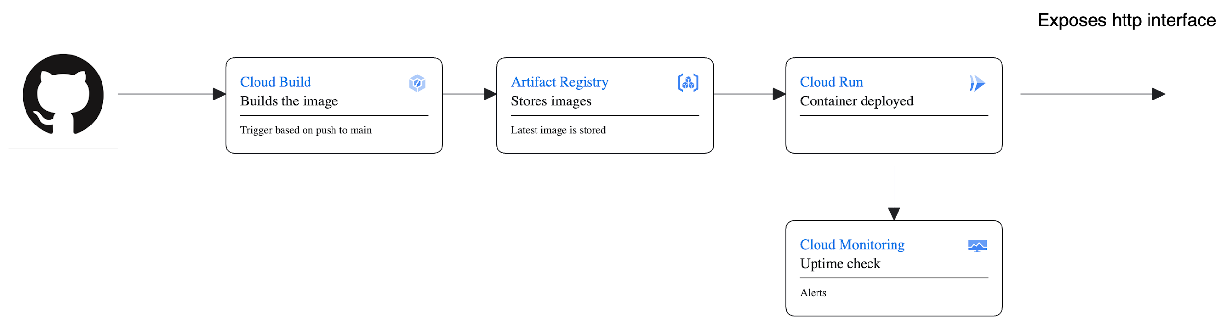
部署作業
您可以將應用程式部署為簡單的節點應用程式,或部署為任何容器環境 (例如 GKE 或 GAE) 中的 Docker。我們在代管的試用版中採用下列架構:
帳單資訊
故事敘述解決方案使用 Google 地圖平台服務,提供身歷其境的動態體驗。部分 API 可能會產生費用。以下是 API 總覽和定價連結。
Google 地圖平台 - 3D Tiles API:
故事述說解決方案會運用 3D 圖塊 API,透過地理空間資料提升視覺體驗。如要瞭解 3D Tiles API 的定價詳情,請參閱 Google 地圖平台 - 3D Tiles API 定價。
Google Places API:
Places API 用於提供位置資訊,為說故事體驗增添豐富資訊。如要瞭解 Google Places API 的相關費用,請前往 Google 地圖平台 - Places API 定價。
Google Maps Autocomplete API:
自動完成功能可提升使用者互動體驗。如要瞭解 Google 地圖自動完成 API 的定價詳情,請前往 Google 地圖平台 - 地點自動完成定價。
CesiumJS:
3D 地球的視覺化效果是透過 CesiumJS 呈現。雖然 CesiumJS 本身是開放原始碼,但其他功能或服務可能會有相關費用。如需任何進階產品,請參閱 CesiumJS 說明文件。
請務必查看各項 API 的價格詳細資料,因為系統會根據使用量個別計算費用。請注意,Google 地圖平台提供免費方案,可免費使用一定量的服務。此外,具體價格可能因要求數量和使用區域等因素而異。
如要瞭解 Google 地圖平台和 CesiumJS 的使用費用,請一律參閱官方定價頁面,取得最準確的最新資訊。請務必遵守這些服務的條款及細則,有效管理及瞭解相關費用。
結論
3D 故事述說解決方案是強大的工具,可將故事述說與地理環境整合,製作身歷其境的精彩敘事內容。無論是新聞報導、旅遊記錄或教育用途,這項解決方案都能協助創作者以獨特且引人入勝的方式吸引觀眾。
3D 故事述說解決方案提供簡單易用的介面、可自訂的功能和動態攝影機控制項,可帶來流暢的故事述說體驗。歡迎探索這項創新工具的潛力,盡情發揮創意,以全新方式呈現生動故事。