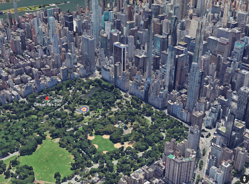
 포토리얼리스틱 3D 타일은 고해상도 이미지로 텍스처 처리된 3D 메시입니다. 전 세계 인구 밀집 지역의 고해상도 3D 지도를 제공합니다. 이를 통해 차세대 몰입형 3D 시각화 환경을 지원하여 사용자가 다음 작업을 할 수 있습니다.
지역 이해하기
자신 있게 위치로 이동
새로운 장소를 평가하여 결정 내리기
실제 세계의 변화 이해하기
시작하기 전에
실사 3D 타일 API를 사용하기 전에 서비스 약관 및 Map Tiles API 정책을 검토해야 합니다. 그런 다음 결제 계정으로 프로젝트를 시작하고 Map Tiles API를 사용 설정할 수 있습니다. 자세한 내용은 Cloud 콘솔에서 설정하기를 참고하세요.
타일 가져오기
API 키를 획득한 후 원하는 3D 타일 렌더러에 루트 타일 세트 URL을 지정하여 사실적인 타일에 액세스할 수 있습니다. 그 후 최종 사용자가 지도를 탐색할 때 렌더러가 포토리얼리스틱 타일에 대한 모든 후속 호출을 자동으로 실행합니다.
렌더링은 단일 루트 타일 세트 요청에서 최소 3시간의 타일 요청을 할 수 있습니다. 이 한도에 도달한 후에는 다른 루트 타일 세트 요청을 해야 합니다.
예를 들어 다음 JavaScript 코드를 사용하여 Cesium JS로 3D 타일을 탐색할 수 있습니다.
<head>
 <meta charset="utf-8">
 <script src="https://ajax.googleapis.com/ajax/libs/cesiumjs/1.105/Build/Cesium/Cesium.js"></script>
 <link href="https://ajax.googleapis.com/ajax/libs/cesiumjs/1.105/Build/Cesium/Widgets/widgets.css" rel="stylesheet">
</head>

<body>
  <div id="cesiumContainer"></div>
  <script>
    const viewer = new Cesium.Viewer('cesiumContainer', {
      imageryProvider: false,
      baseLayerPicker: false,
      requestRenderMode: true,
    });

    const tileset = viewer.scene.primitives.add(new Cesium.Cesium3DTileset({
      url: "https://tile.googleapis.com/v1/3dtiles/root.json?key=YOUR_API_KEY",
      showCreditsOnScreen: true,
    }));

    viewer.scene.globe.show = false;
  </script>
</body>