Koleksiyonlar ile düzeninizi koruyun
İçeriği tercihlerinize göre kaydedin ve kategorilere ayırın.
Avrupa Ekonomik Alanı (AEA) geliştiricileri
Oturum jetonu, bir oturumu (bir dizi ilgili mesaj alışverişi) tanımlamak için REST çağrılarında kullanılan bir veri parçasıdır (UUID). 2D döşemeler ve Street View görüntüleri için yapılan tüm isteklere bir oturum jetonu eklemeniz gerekir.
Bu parametreyi, tüm istek URL'lerine eklenen bir session parametresinin değeri olarak eklersiniz.
Map Tiles API'de oturum jetonu, tanımlanmış bir dizi görüntüleme seçeneğini temsil eder. Bu, her döşeme isteğiyle bir dizi görüntüleme seçeneği iletmeniz gerekmediği anlamına gelir. Aynı oturum jetonunu birden fazla istemcide kullanabilirsiniz.
Oturum jetonu şu anda veriliş tarihinden itibaren iki hafta boyunca geçerlidir ancak bu süre değişebilir. Oturum jetonunun geçerlilik bitiş zamanını, yanıt mesajındaki expiry alanına bakarak her zaman kontrol edebilirsiniz.
Oturum jetonu isteği
Oturum jetonu istemek için aşağıdaki örnekte gösterildiği gibi createSession uç noktasına bir HTTPS POST isteği gönderin. İsteği Content-Type: application/json başlığıyla göndermeniz gerekir.
Temel haritanın türü. Bu değer aşağıdakilerden biri olabilir:
roadmap
Standart Google Haritalar boyalı harita parçaları.
satellite
Uydu görüntüleri.
terrain
Arazi görüntüleri. Harita türü olarak terrain seçildiğinde layerRoadmap katman türünü de eklemeniz gerekir (İsteğe bağlı alanlar bölümünde açıklanmıştır).
streetview
Street View panoramaları. Daha fazla bilgi için Street View Döşemeleri başlıklı makaleyi inceleyin.
language
Döşemelerdeki bilgileri görüntülemek için kullanılan dili belirten bir IETF dil etiketi. Örneğin, en-US, ABD'de konuşulan İngilizce dilini belirtir.
region
Kullanıcının fiziksel konumunu temsil eden bir Common Locale Data Repository bölge tanımlayıcısı (iki büyük harf). Örneğin, US.
İsteğe bağlı alanlar
imageFormat
Döndürülecek dosya biçimini belirtir. Geçerli değerler jpeg veya png'dir.
JPEG dosyaları şeffaflığı desteklemediğinden yer paylaşımı kutuları için önerilmez. imageFormat belirtmezseniz kutucuk için en uygun biçim otomatik olarak seçilir.
scale
Varsayılan kutucuğun kutucuk boyutunu ve kapsama alanını korurken harita öğelerinin (ör. yol etiketleri) boyutunu büyütür. Ölçeği büyütmek, haritadaki etiket sayısını da azaltarak karmaşayı önler. Aşağıdaki değerler geçerli scale değerleridir:
scaleFactor1x: Varsayılan değer.
scaleFactor2x: Etiket boyutunu iki katına çıkarır ve küçük özellik etiketlerini kaldırır.
scaleFactor4x: Etiket boyutunu dört katına çıkarır ve küçük özellik etiketlerini kaldırır.
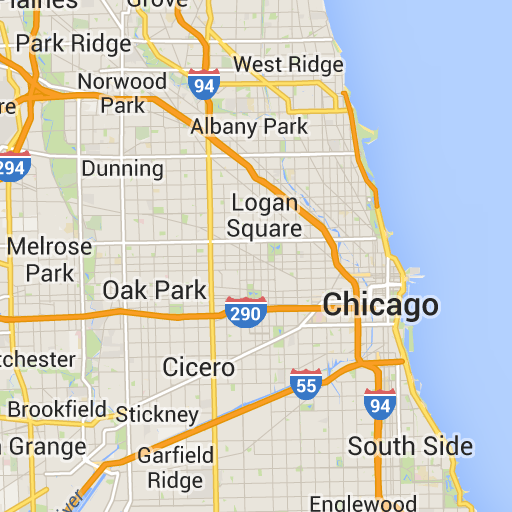
Aşağıdaki örneklerde, harita öğelerini ölçeklendirmenin etkisi gösterilmektedir.
Ölçeklendirme faktörü 1x
Ölçeklendirme faktörü 2x
highDpi
Yüksek çözünürlüklü döşemelerin döndürülüp döndürülmeyeceğini belirtir. Ölçekleme faktörü artırılırsa döşemenin boyutu highDpi kullanılarak artırılır. Normalde, ölçek faktörünü artırmak, sonuçta elde edilen karo görüntüsünü aynı boyutta bir resim haline getirerek büyütür ve bu da kaliteyi düşürür. highDpi ile sonuçtaki boyut da artırılır ve kalite korunur. DPI, inç başına nokta sayısı anlamına gelir. Yüksek DPI, kutunun normalden daha fazla nokta kullanılarak oluşturulduğunu ifade eder. true ise x ve y boyutlarının her birindeki piksel sayısı ölçek faktörüyle (yani 2x veya 4x) çarpılır. Karo kapsam alanı değişmez.
Bu parametre yalnızca 2x veya 4x scale değerleriyle çalışır. Bu durum, 1x ölçekli kutuları etkilemez.
Ölçeklendirme faktörü 1x
Ölçeklendirme Faktörü 2x Yüksek DPI
layerTypes
Haritaya eklenen katman türlerini belirten bir değer dizisi. Geçerli değerler:
layerRoadmap
Harita türü olarak terrain değerini belirtirseniz zorunludur. satellite harita türü üzerine isteğe bağlı olarak da yerleştirilebilir. Yol haritası kutularını etkilemez.
layerStreetview
Haritada Street View'un etkin olduğu sokakları ve yerleri mavi ana hatlarla gösterir.
layerTraffic
Mevcut trafik koşullarını gösterir.
styles
Yollar, parklar ve yerleşim alanları gibi harita özelliklerinin görünümünü ve ayrıntı düzeyini belirten bir JSON stili nesne dizisi. Stil oluşturma, standart Google temel haritasını özelleştirmek için kullanılır. styles parametresi yalnızca harita türü roadmap ise geçerlidir. Stil söz diziminin tamamı için Stil Referansı'na bakın.
overlay
layerTypes öğesinin ayrı bir yer paylaşımı olarak mı oluşturulacağını yoksa temel görüntülerle mi birleştirileceğini belirten bir Boole değeri. true olduğunda temel harita gösterilmez. Herhangi bir layerTypes tanımlamadıysanız bu değer yok sayılır.
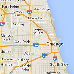
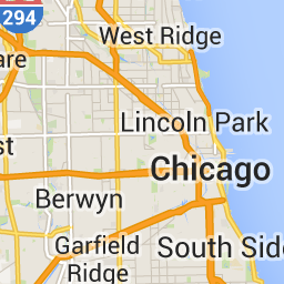
Örneğin, satellite harita türüyle layerRoadmap katmanı isteğinde bulunmak ve overlay değerini false olarak ayarlamak, Maps JavaScript API'de kullanılan hybrid harita türüne eşdeğer döşemelerle sonuçlanır (soldaki resim). overlay ayarı true olarak belirlenmiş aynı harita ve katman türleri, uydu görüntüleri üzerine yerleştirilmek üzere uygun şekilde biçimlendirilmiş bir harita yerleşimi içeren şeffaf bir karo ile sonuçlanır (sağdaki resim).
overlay: yanlış
overlay: true
Aşağıdaki JSON, hem zorunlu hem de isteğe bağlı alanları içeren tipik bir istek gövdesine örnektir.
Bu örnek, uydu görüntüleriyle birleştirmeye uygun bir yer paylaşımı sağlar. Örnekte hem yol haritası hem de Street View katmanı yer alıyor. Sonuç olarak elde edilen harita, Amerika Birleşik Devletleri'nde konuşulduğu şekliyle İngilizce adlar ve verilerle oluşturulur.
Aşağıdaki listede, yanıt gövdesindeki alanların tanımları yer almaktadır.
session
Tüm Harita Döşemeleri API'si isteklerinize eklemeniz gereken bir oturum jetonu değeri.
expiry
Jetonun geçerliliğinin sona erdiği zamanı (epoch'tan beri geçen saniye cinsinden) içeren bir dize. Oturum jetonu, oluşturulma zamanından itibaren iki hafta boyunca geçerlidir ancak bu politika önceden bildirilmeden değişebilir.
[[["Anlaması kolay","easyToUnderstand","thumb-up"],["Sorunumu çözdü","solvedMyProblem","thumb-up"],["Diğer","otherUp","thumb-up"]],[["İhtiyacım olan bilgiler yok","missingTheInformationINeed","thumb-down"],["Çok karmaşık / çok fazla adım var","tooComplicatedTooManySteps","thumb-down"],["Güncel değil","outOfDate","thumb-down"],["Çeviri sorunu","translationIssue","thumb-down"],["Örnek veya kod sorunu","samplesCodeIssue","thumb-down"],["Diğer","otherDown","thumb-down"]],["Son güncelleme tarihi: 2025-09-04 UTC."],[[["\u003cp\u003eSession tokens, represented as UUIDs, are required for accessing 2D Tiles and Street View imagery through the Map Tiles API but not for 3D Tiles.\u003c/p\u003e\n"],["\u003cp\u003eThey define display options for a session, eliminating the need to send them with each tile request and can be used across multiple clients.\u003c/p\u003e\n"],["\u003cp\u003eTo obtain a session token, an HTTPS POST request is sent to the \u003ccode\u003ecreateSession\u003c/code\u003e endpoint with parameters defining the map type, language, region, and optional display settings.\u003c/p\u003e\n"],["\u003cp\u003eThe response includes the session token, its expiration time, and tile dimensions, with the token remaining valid for approximately two weeks.\u003c/p\u003e\n"]]],[],null,["# Use session tokens with Map Tiles API\n\n**European Economic Area (EEA) developers** If your billing address is in the European Economic Area, effective on 8 July 2025, the [Google\n| Maps Platform EEA Terms of Service](https://cloud.google.com/terms/maps-platform/eea) will apply to your use of the Services. [Learn more](/maps/comms/eea/faq). In addition, certain content from the Map Tiles API will no longer be returned. [Learn more](/maps/comms/eea/map-tiles).\n\nA session token is a piece of data (a\n[UUID](https://en.wikipedia.org/wiki/Universally_unique_identifier))\nthat is used in REST calls to identify a\n[session](https://en.wikipedia.org/wiki/Session_(computer_science))---a\nseries of related message exchanges. You must include a session token in all\nrequests for 2D Tiles and Street View imagery.\nYou include it as the value of a `session` parameter appended to all request\nURLs.\n\nIn the Map Tiles API, a session token represents a defined set of\ndisplay options. It means you don't have to pass a set of display options with\neach tile request. You can use the same session token across multiple clients.\nA session token is currently valid for two weeks from its\nissue time, but this might change. You can always check the expiration time of a\nsession token by looking at the `expiry` field in the response message.\n| **Note:** You need to use session tokens for getting 2D Tiles and Street View Tiles, but not for getting 3D Tiles.\n\nSession token request\n---------------------\n\nTo request a session token, send an HTTPS POST request to the `createSession`\nendpoint, as shown in the following example. You must send the request with a\n`Content-Type: application/json` header. \n\n```json\ncurl -X POST -d '{\n \"mapType\": \"streetview\",\n \"language\": \"en-US\",\n \"region\": \"US\"\n}' \\\n-H 'Content-Type: application/json' \\\n\"https://tile.googleapis.com/v1/createSession?key=YOUR_API_KEY\"\n```\n\n### Required fields\n\n`mapType`\n\n: The type of base map. This value can be one of the following:\n\n `roadmap`\n : The standard Google Maps painted map tiles.\n\n `satellite`\n : Satellite imagery.\n\n `terrain`\n : Terrain imagery. When selecting `terrain` as the map type, you must also\n include the `layerRoadmap` layer type (described in the\n [Optional fields](/maps/documentation/tile/session_tokens#optional_fields)\n section).\n\n `streetview`\n : Street View panoramas. For more information, see\n [Street View Tiles](/maps/documentation/tile/streetview).\n\n`language`\n\n: An\n [IETF language tag](https://en.wikipedia.org/wiki/IETF_language_tag)\n that specifies the language used to display information on the tiles. For\n example, `en-US` specifies the English language as spoken in the United States.\n\n`region`\n\n: A\n [Common Locale Data Repository](https://cldr.unicode.org/)\n region identifier (two uppercase letters) that represents the physical location\n of the user. For example, `US`.\n\n### Optional fields\n\n`imageFormat`\n: Specifies the file format to return. Valid values are either `jpeg` or `png`.\n JPEG files don't support transparency, therefore they aren't recommended for\n overlay tiles. If you don't specify an `imageFormat`, then the best format for\n the tile is chosen automatically.\n\n`scale`\n\n: Scales-up the size of map elements (such as road labels), while retaining the\n tile size and coverage area of the default tile. Increasing the scale also\n reduces the number of labels on the map, which reduces clutter. The following\n values are valid `scale` values:\n\n - `scaleFactor1x`: The default.\n - `scaleFactor2x`: Doubles label size and removes minor feature labels.\n - `scaleFactor4x`: Quadruples label size and removes minor feature labels.\n\nThe following examples demonstrate the effect of scaling map elements.\n\n| Scale Factor 1x | Scale Factor 2x |\n|-----------------|-----------------|\n| | |\n\n`highDpi`\n: Specifies whether to return high-resolution tiles. If the scale-factor is\n increased, `highDpi` is used to increase the size of the tile. Normally,\n increasing the scale factor enlarges the resulting tile into an image of the\n same size, which lowers quality. With `highDpi`, the resulting size is also\n increased, preserving quality. DPI stands for Dots per Inch, and High DPI means\n the tile renders using more dots per inch than normal. If `true`, then the\n number of pixels in each of the x and y dimensions is multiplied by the scale\n factor (that is , 2x or 4x). The coverage area of the tile remains unchanged.\n This parameter works only with `scale` values of 2x or 4x. It has no effect on\n 1x scale tiles.\n\n| Scale Factor 1x | Scale Factor 2x High DPI |\n|-----------------|--------------------------|\n| | |\n\n`layerTypes`\n\n: An array of values that specifies the layer types added to the map. Valid\n values are:\n\n `layerRoadmap`\n : Required if you specify `terrain` as the map type. Can also be optionally\n overlaid on the `satellite` map type. Has no effect on roadmap tiles.\n\n `layerStreetview`\n : Shows Street View-enabled streets and locations using blue outlines on the\n map.\n\n `layerTraffic`\n : Displays current traffic conditions.\n\n`styles`\n\n: An array of JSON style objects that specify the appearance and detail level of\n map features such as roads, parks, and built-up areas. Styling is used to\n customize the standard Google base map. The `styles` parameter is valid only if\n the map type is `roadmap`. For the complete style syntax, see the\n [Style Reference](/maps/documentation/tile/style-reference).\n\n`overlay`\n\n: A boolean value that specifies whether `layerTypes` should be\n rendered as a separate overlay, or combined with the base imagery. When\n `true`, the base map isn't displayed. If you haven't defined any `layerTypes`,\n then this value is ignored.\n\nFor example, requesting a `satellite` map type with a `layerRoadmap` layer, and\n`overlay` set to `false` results in tiles equivalent to the `hybrid` map type\nused in the Maps JavaScript API (left image). The same\nmap and layer types with `overlay` set to `true` results in a transparent tile\nwith a map overlay, styled appropriately for overlaying over satellite imagery\n(right image).\n\n| `overlay`: false | `overlay`: true |\n|------------------|-----------------|\n| | |\n\nThe following JSON is an example of a typical request body that contains both\nrequired and optional fields. \n\n {\n \"mapType\": \"satellite\",\n \"language\": \"en-US\",\n \"region\": \"us\",\n \"layerTypes\": [ \"layerRoadmap\", \"layerStreetview\" ],\n \"overlay\": true,\n \"scale\": \"scaleFactor1x\",\n \"styles\": [\n {\n \"stylers\": [\n { \"hue\": \"#00ffe6\" },\n { \"saturation\": -20 }\n ]\n },{\n \"featureType\": \"road\",\n \"elementType\": \"geometry\",\n \"stylers\": [\n { \"lightness\": 100 },\n { \"visibility\": \"simplified\" }\n ]\n }\n ]\n }\n\nThis example provides an overlay that's suitable for combining with satellite\nimagery. The example contains both a roadmap and street view overlay. The\nresulting map is rendered with names and data in the English language, as it's\nspoken in the United States.\n\nSession token response\n----------------------\n\nThe following JSON is an example response body. \n\n {\n \"session\": \"IgAAAHGU9jnAU4KOAfwY3Bcd6eH_WxQsyocSBAdUnAr9pnvTTNXtF9c_27RBo94ytEXTDg\",\n \"expiry\": \"1361828036\",\n \"tileWidth\": 256,\n \"tileHeight\": 256,\n \"imageFormat\": \"png\"\n }\n\nThe following list contains definitions of the fields in the response body.\n\n`session`\n: A session token value that you must include in all of your Map Tiles API\n requests.\n\n`expiry`\n: A string that contains the time (in seconds since the epoch) at which the token\n expires. A session token is valid for two weeks from its creation\n time, but this policy might change without notice.\n\n`tileWidth`\n: The width of the tiles measured in pixels.\n\n`tileHeight`\n: The height of the tiles measured in pixels.\n\n`imageFormat`\n: The image format, which can be either `png` or `jpeg`."]]