
Page Summary
-
The Navigation SDK for Android is intended for mobile apps providing drivers with real-time turn-by-turn navigation and related functionalities.
-
Commercial use is permitted; however, creating products similar to Google Maps, using the SDK in embedded devices (except for projection to systems like Android Auto), and heavy vehicle navigation require explicit consent.
-
Implementations must use Google-provided maps and logos without alteration, while UI customizations should prioritize driver safety and avoid distracting or obstructive elements.
-
Display the Navigation SDK terms of use and disclaimers about independent judgment, potential cost implications, and real-time condition discrepancies to end-users upon first app usage.
This document lists requirements for applications developed with the Navigation SDK for Android.
Acceptable customer implementation use
The Navigation SDK for Android is designed for providing drivers with real-time turn-by-turn navigation in a mobile application. The data generated by the API may also be used in other applications to share information related to driver status and for general tracking of driver locations.
Disallowed customer implementation
The Navigation SDK for Android is allowed only for commercial applications. The Navigation SDK for Android is not allowed for the following categories of use cases without express prior written consent from Google:
- Heavy Vehicle routing or navigation, such as for buses, trucks, or vehicles with road restrictions, unless the Services explicitly specify supporting heavy vehicle navigation.
Content scraping
Road Name and Speed Limit may be returned to you based on user interactions with your app. If you were to capture or persist the Road Name or Speed Limit for use in any other context outside of the user session, this would constitute scraping, which is not allowed by our terms.
Acceptable modifications to the Navigation UI
The Navigation SDK for Android enables certain UI customizations, such as customizing the navigation map, adding custom markers, changing the size and content of the header and footer surrounding the navigation viewport, or changing the size of the navigation viewport itself. In some situations, you might also want to overlay content on top of the active navigation screen.
When doing so, you may not introduce modifications that inhibit safe use by drivers. For example, the following changes can negatively impact driver safety and must be avoided:
- Showing distracting animations during active navigation.
- Showing overlays on the navigation screen without explicit driver action.
- Positioning overlays on the active navigation screen that hide the driver's current location or permanently block important navigation information. This includes upcoming turns, lane guidance, compass orientation, and all standard UI elements in the navigation experience.
- Removing road network from the navigation map or significantly reducing color contrast of map features on the navigation map.
Other implementation requirements
- You may not modify the Navigation SDK in-product terms without the prior written consent from Google.
- Your app must display to your end users the following information upon their
first usage of the app:
- The Navigation SDK terms of use.
- End users should always exercise independent judgment when using navigation, as information from the Navigation SDK Service may differ from actual real-time conditions.
- End users are solely responsible for costs incurred when following the directions provided by the Navigation SDK service, such as for toll fees or high occupancy vehicle lanes.
Google Maps attribution requirements
This section provides attribution requirements and guidelines for displaying Google Maps and Content through your applications.
Display Google Maps attribution
You must follow Google Maps attribution requirements when displaying Content from Google Maps Platform APIs in your app or website. You don't need to add extra attribution if the Content is shown on a Google Map where the attribution is already visible.
Included Google Maps attribution
For Google Maps attribution that is already provided by Google Maps Platform in the user interface:
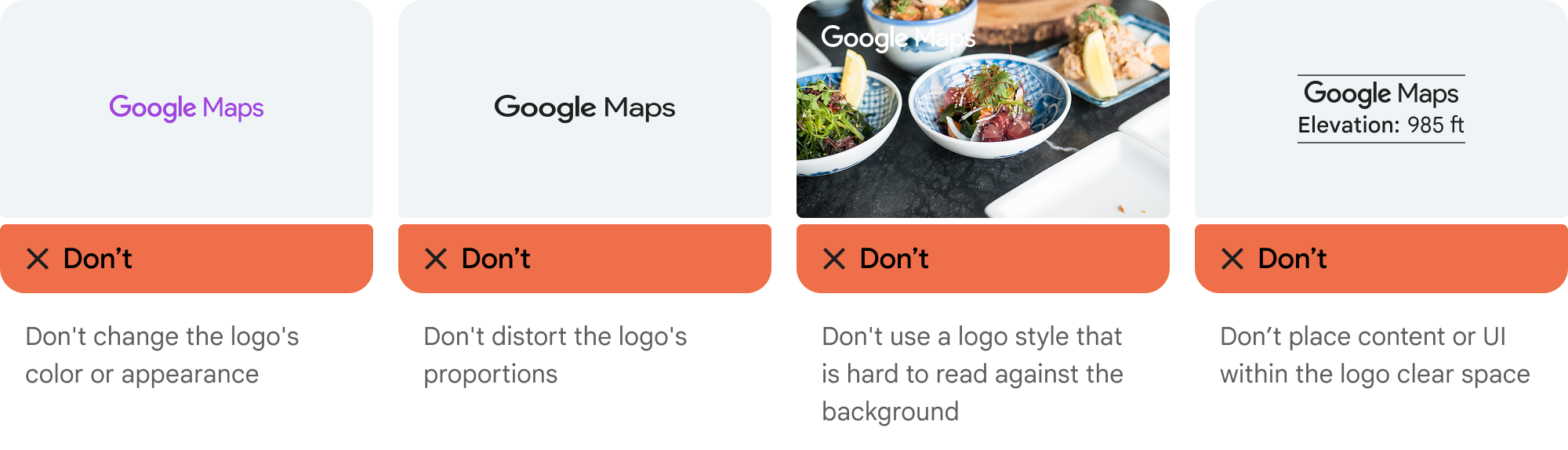
- Don't remove included attribution regardless of where it is displayed. Don't alter, hide, or obscure the attribution and make sure it is clearly visible against the background.
- Always visually distinguish Google Maps Platform Content from other content by using UI cues such as a border, background color, shadow, or sufficient whitespace.
- When making visual modifications, you must adhere to all Google Maps attribution requirements.
Google Maps logo and text attribution
Attribution should take the form of the Google Maps logo whenever possible. In cases where space is limited, the text Google Maps is acceptable. It must always be clear to end users which content is provided by Google Maps.
Logo attribution
Follow these requirements for using the Google Maps logo in your app.Download Google Maps logos
Use the official Google Maps logo files. Download the logos below, and follow the guidelines in this section.
Download the Google Maps attribution assetsWhen using the Google Maps logo, follow these guidelines.
- Don't modify the logo in any way.
- Maintain the aspect ratio of the logo to prevent distortion.
- Use the outlined logo on a busy background, like a map or image.
- Use the non-outlined logo on a plain background, like a solid color or subtle gradient.
Logo size specification
Follow these size specifications for the Google Maps logo:- Minimum logo height: 16dp
- Maximum logo height: 19dp
- Minimum logo clear space: 10dp on left, right and top, 5dp on the bottom
To learn about dp, see Pixel density on the Material Design website.
Logo accessibility
Follow these accessibility requirements for the Google Maps logo:- Maintain an accessible contrast between the logo and the background.
- Include an accessibility label with the text Google Maps.
Text attribution
If the size of your interface does not support using the Google Maps logo, you can spell out Google Maps in text. Follow these guidelines:

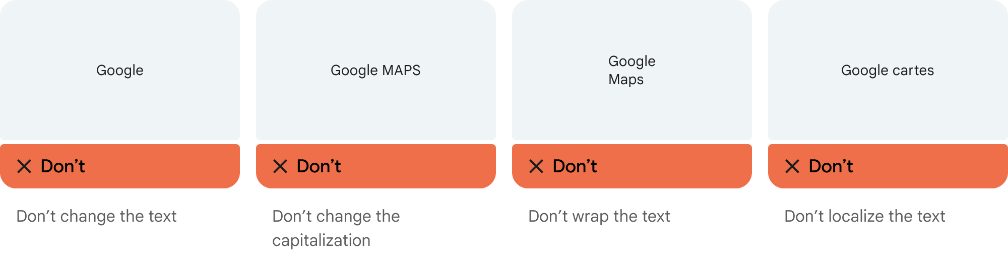
- Don't modify the text Google Maps in any way:
- Don't change the capitalization of Google Maps
- Don't wrap Google Maps onto multiple lines
- Don't localize Google Maps into another language.
- Prevent browsers from translating Google Maps by using the HTML attribute
translate="no".
Style Google Maps text as described in the following table:
Google Maps text-styling requirements Property Style Font family Roboto. Loading the font is optional. Fallback font family Any sans serif body font already used in your product or "Sans-Serif" to invoke the default system font Font style Normal Font weight 400 Font color White, black (#1F1F1F), or gray (#5E5E5E). Maintain accessible (4.5:1) contrast against the background. Font size Minimum font size: 12sp
Maximum font size: 16sp
To learn about sp, see Font size units on the Material Design website.Letter spacing Normal
Example CSS
The following CSS renders Google Maps with the appropriate typographic style and color on a white or light background.
@import url('https://fonts.googleapis.com/css2?family=Roboto&display=swap');

.GMP-attribution {
font-family: Roboto, Sans-Serif;
font-style: normal;
font-weight: 400;
font-size: 1rem;
letter-spacing: normal;
white-space: nowrap;
color: #5e5e5e;
}
Visual requirements
Follow these requirements for the visual treatment of Google Maps attribution.Position attribution near the top or bottom of the content, and within the same visual container. For a single line of content, attribution can be positioned to the right or left.
Visually distinguish Google Maps Platform Content from other content by using UI cues such as a border, background color, shadow, or sufficient whitespace.
- Don't misrepresent Google Maps by attributing it with non-Google Maps Platform content.
- Verify that the attribution is always visible and legible. Never remove, hide, obscure, or modify it.