Organiza tus páginas con colecciones
Guarda y categoriza el contenido según tus preferencias.
Desarrolladores del Espacio Económico Europeo (EEE)
Los mosaicos de hoja de ruta son mosaicos de imágenes basados en datos topográficos vectoriales
con el diseño cartográfico de Google. Esto incluye rutas, edificios, lugares de interés y límites políticos.
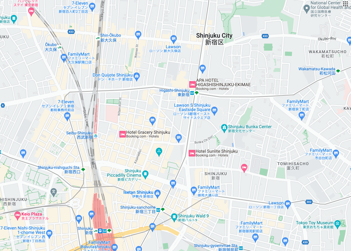
Cómo obtener tarjetas de la hoja de ruta
Puedes comenzar a realizar solicitudes de tarjetas de hoja de ruta después de obtener un token de sesión. Como el token de sesión se aplica a toda la sesión, no es necesario que especifiques las opciones del mapa con tus solicitudes de segmentos.
En la siguiente muestra de código, se muestra una solicitud típica de token de sesión para las tarjetas de ruta.
En esta solicitud GET de HTTPS, z es el nivel de zoom (que va de 0 a 22), y x y y son las coordenadas de la segmentación de la segmentación que deseas recuperar.
El parámetro orientation es opcional. Su valor especifica la cantidad de grados de rotación en sentido contrario a las manecillas del reloj de la imagen de la tarjeta. orientation se admite para las tarjetas roadmap, y también para las solicitudes de imágenes satelitales y de terreno con imágenes base quitadas con "overlay": true y con layerTypes establecido. Los valores válidos de orientation son 0 (predeterminado), 90, 180 y 270.
La cuadrícula de coordenadas de la segmentación no se rota si incluyes un valor de orientation. Por ejemplo, si estableces orientation en 90, la coordenada x seguirá definiendo la posición de izquierda a derecha de la segmentación, que, en este caso, es de norte a sur en el mapa.
Orientación de cero grados
Orientación de 90 grados
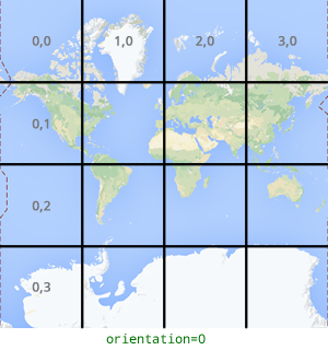
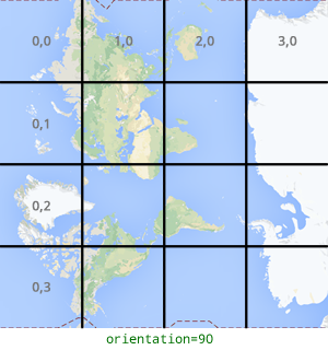
Ejemplo de solicitud de tarjeta
Considera el siguiente ejemplo, en el que se solicita una sola tarjeta que contiene todo el mundo. En este ejemplo, el nivel de zoom es 0 y las coordenadas X e Y son 0, 0.
En este ejemplo, no hay ningún mensaje de respuesta del servidor. En cambio, la tarjeta se descarga en un archivo local con las siguientes estadísticas.
[[["Fácil de comprender","easyToUnderstand","thumb-up"],["Resolvió mi problema","solvedMyProblem","thumb-up"],["Otro","otherUp","thumb-up"]],[["Falta la información que necesito","missingTheInformationINeed","thumb-down"],["Muy complicado o demasiados pasos","tooComplicatedTooManySteps","thumb-down"],["Desactualizado","outOfDate","thumb-down"],["Problema de traducción","translationIssue","thumb-down"],["Problema con las muestras o los códigos","samplesCodeIssue","thumb-down"],["Otro","otherDown","thumb-down"]],["Última actualización: 2025-09-04 (UTC)"],[[["\u003cp\u003eRoadmap tiles provide vector-based topographic data including roads, buildings, points of interest, and political boundaries, styled with Google's cartography.\u003c/p\u003e\n"],["\u003cp\u003eTo get roadmap tiles, you need a session token obtained through an HTTPS POST request with map type, language, and region specified.\u003c/p\u003e\n"],["\u003cp\u003eIndividual tiles are retrieved using an HTTPS GET request, providing the zoom level (z), tile coordinates (x, y), session token, and optionally, orientation.\u003c/p\u003e\n"],["\u003cp\u003eTile coordinates differ from geographic coordinates and range from zoom level 0 (entire world) to 22 (highly detailed).\u003c/p\u003e\n"],["\u003cp\u003eThe optional \u003ccode\u003eorientation\u003c/code\u003e parameter rotates the tile image counter-clockwise by 0, 90, 180, or 270 degrees without affecting the tile coordinate grid.\u003c/p\u003e\n"]]],["Roadmap tiles, based on vector topographic data with Google's styling, are accessed via HTTPS requests. First, obtain a session token using a POST request specifying `roadmap`, `language`, and `region`. Then, make GET requests with the session token, API key, zoom level (`z`), and tile coordinates (`x`, `y`) to retrieve tiles. The optional `orientation` parameter rotates the tile (0, 90, 180, 270 degrees). Tiles are downloaded directly to a local file without a server response message.\n"],null,["# Roadmap tiles\n\n**European Economic Area (EEA) developers** If your billing address is in the European Economic Area, effective on 8 July 2025, the [Google\n| Maps Platform EEA Terms of Service](https://cloud.google.com/terms/maps-platform/eea) will apply to your use of the Services. [Learn more](/maps/comms/eea/faq). In addition, certain content from the Map Tiles API will no longer be returned. [Learn more](/maps/comms/eea/map-tiles).\n\nRoadmap tiles are image tiles based on vector topographic data\nwith Google's cartographic styling. This includes roads, buildings, points\nof interest, and political boundaries.\n\nGetting roadmap tiles\n---------------------\n\nYou can begin making roadmap tile requests after you get a session token. Because the\nsession token applies to the entire session, you don't have to specify the map\noptions with your tile requests.\n\nThe following code sample demonstrates a typical session token request for\nroadmap tiles. \n\n```json\ncurl -X POST -d '{\n \"mapType\": \"roadmap\",\n \"language\": \"en-US\",\n \"region\": \"US\"\n}' \\\n-H 'Content-Type: application/json' \\\n\"https://tile.googleapis.com/v1/createSession?key=YOUR_API_KEY\"\n```\n\nYou get roadmap tiles by making an HTTPS GET request, as shown in the following\nexample. \n\n```json\ncurl \"https://tile.googleapis.com/v1/2dtiles/\u003cvar class=\"apiparam\" translate=\"no\"\u003ez\u003c/var\u003e/\u003cvar class=\"apiparam\" translate=\"no\"\u003ex\u003c/var\u003e/\u003cvar class=\"apiparam\" translate=\"no\"\u003ey\u003c/var\u003e?session=\u003cvar class=\"apiparam\" translate=\"no\"\u003eYOUR_SESSION_TOKEN\u003c/var\u003e&key=YOUR_API_KEY&orientation=\u003cvar class=\"apiparam\" translate=\"no\"\u003e0_or_90_or_180_or_270\u003c/var\u003e\"\n```\n\nIn this HTTPS GET request, \u003cvar class=\"apiparam\" translate=\"no\"\u003e\u003ccode translate=\"no\" dir=\"ltr\"\u003ez\u003c/code\u003e\u003c/var\u003e is the zoom level\n(ranging from 0 to 22), and \u003cvar class=\"apiparam\" translate=\"no\"\u003e\u003ccode translate=\"no\" dir=\"ltr\"\u003ex\u003c/code\u003e\u003c/var\u003e and\n\u003cvar class=\"apiparam\" translate=\"no\"\u003e\u003ccode translate=\"no\" dir=\"ltr\"\u003ey\u003c/code\u003e\u003c/var\u003e are the\n[tile coordinates](/maps/documentation/javascript/coordinates#tile-coordinates)\nof the tile you want to retrieve.\n| **Note:** Tile coordinates are not the same as geographic coordinates. For more information about tile coordinates, see [Map and tile coordinates](/maps/documentation/javascript/coordinates) in the Maps JavaScript API documentation.\n\nThe `orientation` parameter is optional. Its value specifies the number of\ndegrees of counter-clockwise rotation of the tile image. `orientation` is\nsupported for `roadmap` tiles, and it's also supported for satellite and\nterrain requests with base imagery removed using `\"overlay\": true`, and with\n`layerTypes` set. Valid `orientation` values are 0 (the default), 90, 180, and\n270.\n\nThe tile coordinate grid isn't rotated if you include an `orientation`\nvalue. For example, if you set `orientation` to 90, then the\n\u003cvar class=\"apiparam\" translate=\"no\"\u003e\u003ccode translate=\"no\" dir=\"ltr\"\u003ex\u003c/code\u003e\u003c/var\u003e coordinate still defines the left-to-right\nposition of the tile, which in this case is from North to South on the map.\n\n| Zero-degrees orientation | 90-degrees orientation |\n|--------------------------|------------------------|\n| | |\n\nExample tile request\n--------------------\n\nConsider the following example, which requests a single tile that contains the\nentire world. In this example, zoom level is 0, and the x and y coordinates are\n0, 0. \n\n```json\ncurl \"https://tile.googleapis.com/v1/2dtiles/0/0/0?session=\u003cvar class=\"apiparam\" translate=\"no\"\u003eYOUR_SESSION_TOKEN\u003c/var\u003e&key=YOUR_API_KEY\" --output /tmp/example_tile.png\n```\n\nThere is no response message from the server in this example. Instead, the tile\ndownloads to a local file, with the following statistics.\n\n```bash\n 
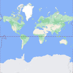
% Total % Received % Xferd Average Speed Time Time Time Current\n Dload Upload Total Spent Left Speed\n100 8335 100 8335 0 0 51471 0 --:--:-- --:--:-- --:--:-- 54835\n```\n\nFor information about response message headers, see\n[Pre-Fetching, Caching, or Storage of Content](/maps/documentation/tile/policies#pre-fetching,-caching,-or-storage-of-content)."]]