Mantenha tudo organizado com as coleções
Salve e categorize o conteúdo com base nas suas preferências.
Desenvolvedores do Espaço Econômico Europeu (EEE)
Os blocos de roteiro são blocos de imagens baseados em dados topográficos vetoriais
com o estilo cartográfico do Google. Isso inclui vias, edifícios, pontos de interesse e limites políticos.
Como acessar blocos de estratégia
Você pode começar a fazer solicitações de bloco de roteiro depois de receber um token de sessão. Como o token de sessão se aplica a toda a sessão, não é necessário especificar as opções de mapa com as solicitações de bloco.
O exemplo de código a seguir demonstra uma solicitação de token de sessão típica para
blocos de roteiro.
Nesta solicitação HTTPS GET, z é o nível de zoom (de 0 a 22), e x e y são as coordenadas do bloco que você quer recuperar.
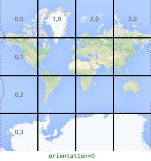
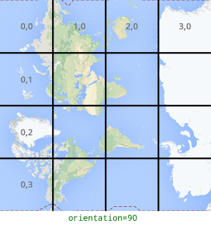
O parâmetro orientation é opcional. O valor especifica o número de
graus de rotação no sentido anti-horário da imagem do bloco. O orientation é compatível com blocos roadmap e também com solicitações de satélite e terreno com imagens de base removidas usando "overlay": true e com layerTypes definido. Os valores válidos de orientation são 0 (padrão), 90, 180 e 270.
A grade de coordenadas do bloco não é girada se você incluir um valor orientation. Por exemplo, se você definir orientation como 90, a coordenada x ainda definirá a posição da esquerda para a direita do bloco, que, nesse caso, é de norte a sul no mapa.
Orientação de zero grau
Orientação de 90 graus
Exemplo de solicitação de bloco
Considere o exemplo a seguir, que solicita um único bloco que contém o mundo inteiro. Neste exemplo, o nível de zoom é 0, e as coordenadas x e y são 0, 0.
[[["Fácil de entender","easyToUnderstand","thumb-up"],["Meu problema foi resolvido","solvedMyProblem","thumb-up"],["Outro","otherUp","thumb-up"]],[["Não contém as informações de que eu preciso","missingTheInformationINeed","thumb-down"],["Muito complicado / etapas demais","tooComplicatedTooManySteps","thumb-down"],["Desatualizado","outOfDate","thumb-down"],["Problema na tradução","translationIssue","thumb-down"],["Problema com as amostras / o código","samplesCodeIssue","thumb-down"],["Outro","otherDown","thumb-down"]],["Última atualização 2025-09-04 UTC."],[[["\u003cp\u003eRoadmap tiles provide vector-based topographic data including roads, buildings, points of interest, and political boundaries, styled with Google's cartography.\u003c/p\u003e\n"],["\u003cp\u003eTo get roadmap tiles, you need a session token obtained through an HTTPS POST request with map type, language, and region specified.\u003c/p\u003e\n"],["\u003cp\u003eIndividual tiles are retrieved using an HTTPS GET request, providing the zoom level (z), tile coordinates (x, y), session token, and optionally, orientation.\u003c/p\u003e\n"],["\u003cp\u003eTile coordinates differ from geographic coordinates and range from zoom level 0 (entire world) to 22 (highly detailed).\u003c/p\u003e\n"],["\u003cp\u003eThe optional \u003ccode\u003eorientation\u003c/code\u003e parameter rotates the tile image counter-clockwise by 0, 90, 180, or 270 degrees without affecting the tile coordinate grid.\u003c/p\u003e\n"]]],["Roadmap tiles, based on vector topographic data with Google's styling, are accessed via HTTPS requests. First, obtain a session token using a POST request specifying `roadmap`, `language`, and `region`. Then, make GET requests with the session token, API key, zoom level (`z`), and tile coordinates (`x`, `y`) to retrieve tiles. The optional `orientation` parameter rotates the tile (0, 90, 180, 270 degrees). Tiles are downloaded directly to a local file without a server response message.\n"],null,["# Roadmap tiles\n\n**European Economic Area (EEA) developers** If your billing address is in the European Economic Area, effective on 8 July 2025, the [Google\n| Maps Platform EEA Terms of Service](https://cloud.google.com/terms/maps-platform/eea) will apply to your use of the Services. [Learn more](/maps/comms/eea/faq). In addition, certain content from the Map Tiles API will no longer be returned. [Learn more](/maps/comms/eea/map-tiles).\n\nRoadmap tiles are image tiles based on vector topographic data\nwith Google's cartographic styling. This includes roads, buildings, points\nof interest, and political boundaries.\n\nGetting roadmap tiles\n---------------------\n\nYou can begin making roadmap tile requests after you get a session token. Because the\nsession token applies to the entire session, you don't have to specify the map\noptions with your tile requests.\n\nThe following code sample demonstrates a typical session token request for\nroadmap tiles. \n\n```json\ncurl -X POST -d '{\n \"mapType\": \"roadmap\",\n \"language\": \"en-US\",\n \"region\": \"US\"\n}' \\\n-H 'Content-Type: application/json' \\\n\"https://tile.googleapis.com/v1/createSession?key=YOUR_API_KEY\"\n```\n\nYou get roadmap tiles by making an HTTPS GET request, as shown in the following\nexample. \n\n```json\ncurl \"https://tile.googleapis.com/v1/2dtiles/\u003cvar class=\"apiparam\" translate=\"no\"\u003ez\u003c/var\u003e/\u003cvar class=\"apiparam\" translate=\"no\"\u003ex\u003c/var\u003e/\u003cvar class=\"apiparam\" translate=\"no\"\u003ey\u003c/var\u003e?session=\u003cvar class=\"apiparam\" translate=\"no\"\u003eYOUR_SESSION_TOKEN\u003c/var\u003e&key=YOUR_API_KEY&orientation=\u003cvar class=\"apiparam\" translate=\"no\"\u003e0_or_90_or_180_or_270\u003c/var\u003e\"\n```\n\nIn this HTTPS GET request, \u003cvar class=\"apiparam\" translate=\"no\"\u003e\u003ccode translate=\"no\" dir=\"ltr\"\u003ez\u003c/code\u003e\u003c/var\u003e is the zoom level\n(ranging from 0 to 22), and \u003cvar class=\"apiparam\" translate=\"no\"\u003e\u003ccode translate=\"no\" dir=\"ltr\"\u003ex\u003c/code\u003e\u003c/var\u003e and\n\u003cvar class=\"apiparam\" translate=\"no\"\u003e\u003ccode translate=\"no\" dir=\"ltr\"\u003ey\u003c/code\u003e\u003c/var\u003e are the\n[tile coordinates](/maps/documentation/javascript/coordinates#tile-coordinates)\nof the tile you want to retrieve.\n| **Note:** Tile coordinates are not the same as geographic coordinates. For more information about tile coordinates, see [Map and tile coordinates](/maps/documentation/javascript/coordinates) in the Maps JavaScript API documentation.\n\nThe `orientation` parameter is optional. Its value specifies the number of\ndegrees of counter-clockwise rotation of the tile image. `orientation` is\nsupported for `roadmap` tiles, and it's also supported for satellite and\nterrain requests with base imagery removed using `\"overlay\": true`, and with\n`layerTypes` set. Valid `orientation` values are 0 (the default), 90, 180, and\n270.\n\nThe tile coordinate grid isn't rotated if you include an `orientation`\nvalue. For example, if you set `orientation` to 90, then the\n\u003cvar class=\"apiparam\" translate=\"no\"\u003e\u003ccode translate=\"no\" dir=\"ltr\"\u003ex\u003c/code\u003e\u003c/var\u003e coordinate still defines the left-to-right\nposition of the tile, which in this case is from North to South on the map.\n\n| Zero-degrees orientation | 90-degrees orientation |\n|--------------------------|------------------------|\n| | |\n\nExample tile request\n--------------------\n\nConsider the following example, which requests a single tile that contains the\nentire world. In this example, zoom level is 0, and the x and y coordinates are\n0, 0. \n\n```json\ncurl \"https://tile.googleapis.com/v1/2dtiles/0/0/0?session=\u003cvar class=\"apiparam\" translate=\"no\"\u003eYOUR_SESSION_TOKEN\u003c/var\u003e&key=YOUR_API_KEY\" --output /tmp/example_tile.png\n```\n\nThere is no response message from the server in this example. Instead, the tile\ndownloads to a local file, with the following statistics.\n\n```bash\n 
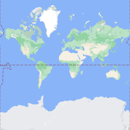
% Total % Received % Xferd Average Speed Time Time Time Current\n Dload Upload Total Spent Left Speed\n100 8335 100 8335 0 0 51471 0 --:--:-- --:--:-- --:--:-- 54835\n```\n\nFor information about response message headers, see\n[Pre-Fetching, Caching, or Storage of Content](/maps/documentation/tile/policies#pre-fetching,-caching,-or-storage-of-content)."]]