
 ロードマップ タイルは、Google の地図作成スタイルを使用したベクター地形データに基づく画像タイルです。これには、道路、建物、スポット
、行政境界が含まれます。
ロードマップ タイルは、Google の地図作成スタイルを使用したベクター地形データに基づく画像タイルです。これには、道路、建物、スポット
、行政境界が含まれます。
ロードマップ タイルを取得する
セッション トークンを取得したら、ロードマップ タイルのリクエストを開始できます。セッション トークンはセッション全体に適用されるため、タイル リクエストで地図オプションを指定する必要はありません。
次のコードサンプルは、ロードマップ タイルの一般的なセッション トークン リクエストを示しています。
curl -X POST -d '{
  "mapType": "roadmap",
  "language": "en-US",
  "region": "US"
}' \
-H 'Content-Type: application/json' \
"https://tile.googleapis.com/v1/createSession?key=YOUR_API_KEY"
次の例に示すように、HTTPS GET リクエストを行うことでロードマップ タイルを取得できます。
curl "https://tile.googleapis.com/v1/2dtiles/z/x/y?session=YOUR_SESSION_TOKEN &key=YOUR_API_KEY &orientation=0_or_90_or_180_or_270"
この HTTPS GET リクエストでは、z はズームレベル
(0 ~ 22)、x と
y は
取得するタイルのタイル座標
です。
orientation パラメータは省略可能です。この値は、タイル画像を反時計回りに回転させる角度を指定します。orientation は roadmap タイルでサポートされています。また、"overlay": true を使用してベース画像が削除され、layerTypes が設定された衛星画像と地形のリクエストでもサポートされています。有効な orientation 値は 0(デフォルト)、90、180、270 です。
orientation 値を指定しても、タイル座標グリッドは回転しません。たとえば、orientation を 90 に設定した場合でも、x 座標はタイルの左右の位置を定義します。この場合、地図上の北から南になります。
| 0 度の画面の向き | 90 度の画面の向き |
|---|---|
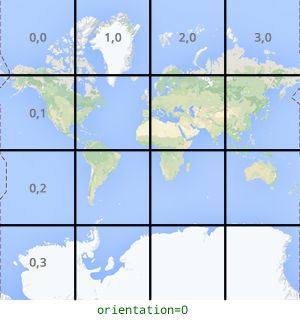 |
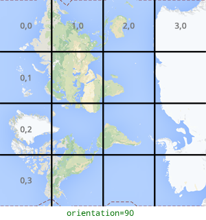 |
タイル リクエストの例
次の例では、世界全体を含む単一のタイルをリクエストします。この例では、ズームレベルは 0 で、x 座標と y 座標は 0, 0 です。
curl "https://tile.googleapis.com/v1/2dtiles/0/0/0?session=YOUR_SESSION_TOKEN&key=YOUR_API_KEY" --output /tmp/example_tile.png
この例では、サーバーからのレスポンス メッセージはありません。代わりに、タイルがローカル ファイルにダウンロードされ、次の統計情報が表示されます。
  % Total    % Received % Xferd  Average Speed   Time    Time     Time  Current
                                 Dload  Upload   Total   Spent    Left  Speed
100  8335  100  8335    0     0  51471      0 --:--:-- --:--:-- --:--:-- 54835
レスポンス メッセージ ヘッダーについて詳しくは、 コンテンツのプリフェッチ、キャッシュ保存、保存をご覧ください。