Sử dụng bộ sưu tập để sắp xếp ngăn nắp các trang
Lưu và phân loại nội dung dựa trên lựa chọn ưu tiên của bạn.
Nhà phát triển ở Khu vực kinh tế Châu Âu (EEA)
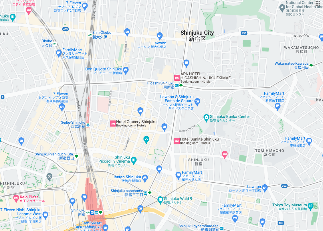
Ô bản đồ đường đi là các ô hình ảnh dựa trên dữ liệu địa hình dạng vectơ theo phong cách vẽ bản đồ của Google. Điều này bao gồm đường, toà nhà, địa điểm yêu thích và ranh giới hành chính.
Lấy ô lộ trình
Bạn có thể bắt đầu đưa ra yêu cầu về ô trên lộ trình sau khi nhận được mã thông báo phiên. Vì mã thông báo phiên áp dụng cho toàn bộ phiên, nên bạn không phải chỉ định các lựa chọn về bản đồ bằng yêu cầu về ô.
Mẫu mã sau đây minh hoạ một yêu cầu mã thông báo phiên điển hình cho các ô trên lộ trình.
Trong yêu cầu HTTPS GET này, z là mức thu phóng (từ 0 đến 22), còn x và y là toạ độ ô của ô mà bạn muốn truy xuất.
Tham số orientation là không bắt buộc. Giá trị của tham số này chỉ định số độ xoay ngược chiều kim đồng hồ của hình ảnh ô. orientation được hỗ trợ cho các ô roadmap, đồng thời cũng được hỗ trợ cho các yêu cầu về vệ tinh và địa hình khi hình ảnh cơ sở bị xoá bằng "overlay": true và khi layerTypes được đặt. Các giá trị orientation hợp lệ là 0 (mặc định), 90, 180 và 270.
Lưới toạ độ ô sẽ không xoay nếu bạn thêm giá trị orientation. Ví dụ: nếu bạn đặt orientation thành 90, thì toạ độ x vẫn xác định vị trí từ trái sang phải của ô, trong trường hợp này là từ Bắc xuống Nam trên bản đồ.
Hướng 0 độ
Hướng 90 độ
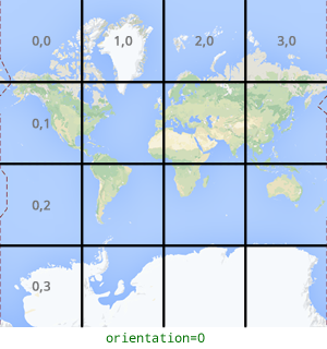
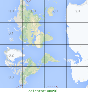
Ví dụ về yêu cầu đối với ô
Hãy xem xét ví dụ sau đây, yêu cầu một ô duy nhất chứa toàn bộ thế giới. Trong ví dụ này, mức thu phóng là 0 và toạ độ x và y là 0, 0.
[[["Dễ hiểu","easyToUnderstand","thumb-up"],["Giúp tôi giải quyết được vấn đề","solvedMyProblem","thumb-up"],["Khác","otherUp","thumb-up"]],[["Thiếu thông tin tôi cần","missingTheInformationINeed","thumb-down"],["Quá phức tạp/quá nhiều bước","tooComplicatedTooManySteps","thumb-down"],["Đã lỗi thời","outOfDate","thumb-down"],["Vấn đề về bản dịch","translationIssue","thumb-down"],["Vấn đề về mẫu/mã","samplesCodeIssue","thumb-down"],["Khác","otherDown","thumb-down"]],["Cập nhật lần gần đây nhất: 2025-09-04 UTC."],[[["\u003cp\u003eRoadmap tiles provide vector-based topographic data including roads, buildings, points of interest, and political boundaries, styled with Google's cartography.\u003c/p\u003e\n"],["\u003cp\u003eTo get roadmap tiles, you need a session token obtained through an HTTPS POST request with map type, language, and region specified.\u003c/p\u003e\n"],["\u003cp\u003eIndividual tiles are retrieved using an HTTPS GET request, providing the zoom level (z), tile coordinates (x, y), session token, and optionally, orientation.\u003c/p\u003e\n"],["\u003cp\u003eTile coordinates differ from geographic coordinates and range from zoom level 0 (entire world) to 22 (highly detailed).\u003c/p\u003e\n"],["\u003cp\u003eThe optional \u003ccode\u003eorientation\u003c/code\u003e parameter rotates the tile image counter-clockwise by 0, 90, 180, or 270 degrees without affecting the tile coordinate grid.\u003c/p\u003e\n"]]],["Roadmap tiles, based on vector topographic data with Google's styling, are accessed via HTTPS requests. First, obtain a session token using a POST request specifying `roadmap`, `language`, and `region`. Then, make GET requests with the session token, API key, zoom level (`z`), and tile coordinates (`x`, `y`) to retrieve tiles. The optional `orientation` parameter rotates the tile (0, 90, 180, 270 degrees). Tiles are downloaded directly to a local file without a server response message.\n"],null,["# Roadmap tiles\n\n**European Economic Area (EEA) developers** If your billing address is in the European Economic Area, effective on 8 July 2025, the [Google\n| Maps Platform EEA Terms of Service](https://cloud.google.com/terms/maps-platform/eea) will apply to your use of the Services. [Learn more](/maps/comms/eea/faq). In addition, certain content from the Map Tiles API will no longer be returned. [Learn more](/maps/comms/eea/map-tiles).\n\nRoadmap tiles are image tiles based on vector topographic data\nwith Google's cartographic styling. This includes roads, buildings, points\nof interest, and political boundaries.\n\nGetting roadmap tiles\n---------------------\n\nYou can begin making roadmap tile requests after you get a session token. Because the\nsession token applies to the entire session, you don't have to specify the map\noptions with your tile requests.\n\nThe following code sample demonstrates a typical session token request for\nroadmap tiles. \n\n```json\ncurl -X POST -d '{\n \"mapType\": \"roadmap\",\n \"language\": \"en-US\",\n \"region\": \"US\"\n}' \\\n-H 'Content-Type: application/json' \\\n\"https://tile.googleapis.com/v1/createSession?key=YOUR_API_KEY\"\n```\n\nYou get roadmap tiles by making an HTTPS GET request, as shown in the following\nexample. \n\n```json\ncurl \"https://tile.googleapis.com/v1/2dtiles/\u003cvar class=\"apiparam\" translate=\"no\"\u003ez\u003c/var\u003e/\u003cvar class=\"apiparam\" translate=\"no\"\u003ex\u003c/var\u003e/\u003cvar class=\"apiparam\" translate=\"no\"\u003ey\u003c/var\u003e?session=\u003cvar class=\"apiparam\" translate=\"no\"\u003eYOUR_SESSION_TOKEN\u003c/var\u003e&key=YOUR_API_KEY&orientation=\u003cvar class=\"apiparam\" translate=\"no\"\u003e0_or_90_or_180_or_270\u003c/var\u003e\"\n```\n\nIn this HTTPS GET request, \u003cvar class=\"apiparam\" translate=\"no\"\u003e\u003ccode translate=\"no\" dir=\"ltr\"\u003ez\u003c/code\u003e\u003c/var\u003e is the zoom level\n(ranging from 0 to 22), and \u003cvar class=\"apiparam\" translate=\"no\"\u003e\u003ccode translate=\"no\" dir=\"ltr\"\u003ex\u003c/code\u003e\u003c/var\u003e and\n\u003cvar class=\"apiparam\" translate=\"no\"\u003e\u003ccode translate=\"no\" dir=\"ltr\"\u003ey\u003c/code\u003e\u003c/var\u003e are the\n[tile coordinates](/maps/documentation/javascript/coordinates#tile-coordinates)\nof the tile you want to retrieve.\n| **Note:** Tile coordinates are not the same as geographic coordinates. For more information about tile coordinates, see [Map and tile coordinates](/maps/documentation/javascript/coordinates) in the Maps JavaScript API documentation.\n\nThe `orientation` parameter is optional. Its value specifies the number of\ndegrees of counter-clockwise rotation of the tile image. `orientation` is\nsupported for `roadmap` tiles, and it's also supported for satellite and\nterrain requests with base imagery removed using `\"overlay\": true`, and with\n`layerTypes` set. Valid `orientation` values are 0 (the default), 90, 180, and\n270.\n\nThe tile coordinate grid isn't rotated if you include an `orientation`\nvalue. For example, if you set `orientation` to 90, then the\n\u003cvar class=\"apiparam\" translate=\"no\"\u003e\u003ccode translate=\"no\" dir=\"ltr\"\u003ex\u003c/code\u003e\u003c/var\u003e coordinate still defines the left-to-right\nposition of the tile, which in this case is from North to South on the map.\n\n| Zero-degrees orientation | 90-degrees orientation |\n|--------------------------|------------------------|\n| | |\n\nExample tile request\n--------------------\n\nConsider the following example, which requests a single tile that contains the\nentire world. In this example, zoom level is 0, and the x and y coordinates are\n0, 0. \n\n```json\ncurl \"https://tile.googleapis.com/v1/2dtiles/0/0/0?session=\u003cvar class=\"apiparam\" translate=\"no\"\u003eYOUR_SESSION_TOKEN\u003c/var\u003e&key=YOUR_API_KEY\" --output /tmp/example_tile.png\n```\n\nThere is no response message from the server in this example. Instead, the tile\ndownloads to a local file, with the following statistics.\n\n```bash\n % Total % Received % Xferd Average Speed Time Time Time Current\n Dload Upload Total Spent Left Speed\n100 8335 100 8335 0 0 51471 0 --:--:-- --:--:-- --:--:-- 54835\n```\n\nFor information about response message headers, see\n[Pre-Fetching, Caching, or Storage of Content](/maps/documentation/tile/policies#pre-fetching,-caching,-or-storage-of-content)."]]