
사용자는 지도에서 동작을 사용하여 카메라의 확대/축소, 기울기, 위치, 회전을 제어할 수 있습니다. 프로그래매틱 방식으로 카메라를 구성할 수도 있습니다.
카메라 위치
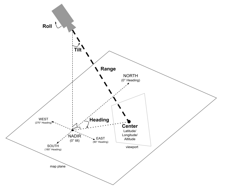
지도 뷰는 카메라가 공간의 특정 지점을 바라보는 것으로 모델링되었습니다. 카메라의 위치와 방향은 위도/경도/고도 좌표, 방위, 기울기, 범위, 회전으로 정의됩니다.
위도, 경도, 고도
카메라의 초기 위치는 위도, 경도, 고도를 설정하여 정의됩니다. 이러한 값은 카메라가 향하거나 중앙에 있는 위치가 아닌 카메라가 배치된 위치를 결정하기 위해 결합됩니다.
위도는 -90도 이상 90도 이하로 설정할 수 있습니다. 경도는 -180도 이상 180도 이하로 설정할 수 있습니다. 고도는 해발 미터로 지정됩니다.
이 범위보다 크거나 작은 값은 범위 내의 가장 가까운 값으로 고정됩니다. 예를 들어 위도를 100으로 지정하면 값이 90으로 설정됩니다.
제목
방위는 지도의 나침반 방향을 지정하며, 진북에서 시계 방향으로 측정됩니다(단위: 도). 북쪽은 0도, 동쪽은 90도, 남쪽은 180도, 서쪽은 270도에 해당합니다.
기울이기
기울기는 수직 축을 기준으로 카메라의 각도를 지정하며, 단위는 도입니다. 기울기가 0도이면 카메라가 지구 (천저)를 향해 아래로 향합니다. 기울기가 90도이면 카메라가 회전으로 지정된 방향을 향해 수평으로 향합니다.
범위
범위는 카메라의 자체 위치와 지도의 중심 사이의 거리(미터)를 정의합니다. 범위는 0미터 (매우 가까운 거리)에서 최대 6,300만 미터까지 다양하며, 매우 가까운 거리에서부터 진정한 글로벌 관점까지 다양한 뷰를 제공합니다. 이렇게 하면 지도가 '확대' 또는 '축소'되는 방식이 효과적으로 제어됩니다.
롤
롤은 수평선에 대한 카메라의 각도를 설정하며, 단위는 도입니다. 이 매개변수를 사용하면 비행 시뮬레이션 중 뱅킹과 같은 효과를 만들거나 카메라를 시청 축을 중심으로 회전시켜 완전한 배럴 롤을 만들 수도 있습니다.
카메라 제어
다음 코드 샘플은 프로그래매틱 방식으로 카메라를 제어하는 방법을 보여줍니다.Swift
public static var sanFrancisco: Camera = .init(
  center: .init(
    latitude: 37.7845812,
    longitude: -122.3660241,
    altitude: 585),
  fieldOfView: .init(degrees: 100),
  altitudeMode: .relativeToGround,
  heading: 288.0,
  tilt: 75.0,
  roll: 0.0,
  range: 100)