
 로드맵 타일은 Google의 지도 제작 스타일이 적용된 벡터 지형 데이터를 기반으로 하는 이미지 타일입니다. 여기에는 도로, 건물, 관심 장소, 정치적 경계가 포함됩니다.
로드맵 타일 가져오기
세션 토큰을 가져온 후 로드맵 타일 요청을 시작할 수 있습니다. 세션 토큰은 전체 세션에 적용되므로 타일 요청과 함께 지도 옵션을 지정할 필요가 없습니다.
다음 코드 샘플은 로드맵 타일에 대한 일반적인 세션 토큰 요청을 보여줍니다.
curl -X POST -d '{
  "mapType": "roadmap",
  "language": "en-US",
  "region": "US"
}' \
-H 'Content-Type: application/json' \
"https://tile.googleapis.com/v1/createSession?key=YOUR_API_KEY"
다음 예와 같이 HTTPS GET 요청을 실행하여 로드맵 타일을 가져옵니다.
curl "https://tile.googleapis.com/v1/2dtiles/z/x/y?session=YOUR_SESSION_TOKEN &key=YOUR_API_KEY &orientation=0_or_90_or_180_or_270"
이 HTTPS GET 요청에서 z는 확대/축소 수준
(0~22)이고 x 및
y는 가져오려는 타일의
타일 좌표입니다.
orientation 매개변수는 선택사항입니다. 이 값은 타일 이미지의 시계 반대 방향 회전 각도를 지정합니다. orientation은 roadmap 타일에 지원되며, `"overlay": true`를 사용하여 기본 이미지가 삭제되고 layerTypes가 설정된 위성 및 지형 요청에도 지원됩니다."overlay": true 유효한 orientation 값은 0 (기본값), 90, 180, 270입니다.
orientation 값을 포함하면 타일 좌표 그리드가 회전하지 않습니다. 예를 들어 orientation을 90으로 설정하면 x 좌표는 여전히 타일의 왼쪽에서 오른쪽 위치를 정의합니다. 이 경우 지도에서 북쪽에서 남쪽입니다.
| 0도 방향 | 90도 방향 |
|---|---|
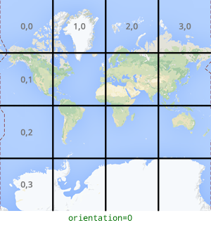 |
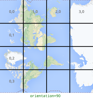 |
타일 요청 예시
전 세계를 포함하는 단일 타일을 요청하는 다음 예를 참고하세요. 이 예에서 확대/축소 수준은 0이고 x 및 y 좌표는 0, 0입니다.
curl "https://tile.googleapis.com/v1/2dtiles/0/0/0?session=YOUR_SESSION_TOKEN&key=YOUR_API_KEY" --output /tmp/example_tile.png
이 예에는 서버의 응답 메시지가 없습니다. 대신 타일이 다음 통계와 함께 로컬 파일에 다운로드됩니다.
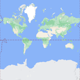
  % Total    % Received % Xferd  Average Speed   Time    Time     Time  Current
                                 Dload  Upload   Total   Spent    Left  Speed
100  8335  100  8335    0     0  51471      0 --:--:-- --:--:-- --:--:-- 54835
응답 메시지 헤더에 대한 자세한 내용은 콘텐츠 프리패치, 캐싱 또는 저장을 참고하세요.