
Bir işaretçinin
altitude
değerini,
altitudeMode
özelliğini aşağıdaki değerlerden birine ayarlayarak belirleyebilirsiniz:
ABSOLUTERELATIVE_TO_GROUNDCLAMP_TO_GROUNDRELATIVE_TO_MESH
Aşağıdaki kod örneğinde, yöntemlerin her birinin nasıl kullanılacağı gösterilmektedir. Bu kod örneğini kullanmak için Kurulum ve Uygulamanıza 3D harita ekleme bölümündeki talimatları uygulayarak Android Studio projenizi temel bir 3D harita ile ayarlayın. Ardından, aşağıdaki kodu
MainActivity.kt dosyasına ekleyin:
// Add imports
import com.google.android.gms.maps3d.model.latLngAltitude
...
// Add to the onMap3DViewReady method, after the googleMap3D object has been initialized
googleMap3D.setMapMode(Map3DMode.SATELLITE)
googleMap3D.setCamera(
camera {
center = latLngAltitude {
latitude = 52.51974795
longitude = 13.40715553
altitude = 150.0
}
heading = 252.7
tilt = 79.0
range = 1500.0
}
)
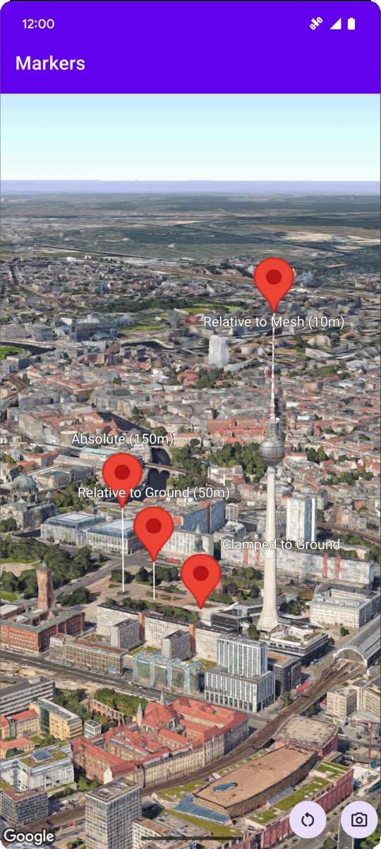
// Marker 1: Absolute
googleMap3D.addMarker(markerOptions {
position = latLngAltitude {
latitude = 52.519605780912585
longitude = 13.406867190588198
altitude = 150.0
}
label = "Absolute (150m)"
altitudeMode = AltitudeMode.ABSOLUTE
isExtruded = true
isDrawnWhenOccluded = true
collisionBehavior = CollisionBehavior.REQUIRED_AND_HIDES_OPTIONAL
})
// Marker 2: Relative to Ground
googleMap3D.addMarker(markerOptions {
position = latLngAltitude {
latitude = 52.519882191069016
longitude = 13.407410777254293
altitude = 50.0
}
label = "Relative to Ground (50m)"
altitudeMode = AltitudeMode.RELATIVE_TO_GROUND
isExtruded = true
isDrawnWhenOccluded = true
})
// Marker 3: Clamped to Ground
googleMap3D.addMarker(markerOptions {
position = latLngAltitude {
latitude = 52.52027645136134
longitude = 13.408271658592406
altitude = 0.0 // altitude is effectively ignored by CLAMP_TO_GROUND for rendering,
// but might be relevant if you read the marker's position later.
// For CLAMP_TO_GROUND, it's often set to 0.0.
}
label = "Clamped to Ground"
altitudeMode = AltitudeMode.CLAMP_TO_GROUND
isExtruded = true
isDrawnWhenOccluded = true
})
// Marker 4: Relative to Mesh
googleMap3D.addMarker(markerOptions {
position = latLngAltitude {
latitude = 52.520835071144226
longitude = 13.409426847943774
altitude = 10.0 // Altitude relative to 3D mesh (buildings, terrain features)
}
label = "Relative to Mesh (10m)"
altitudeMode = AltitudeMode.RELATIVE_TO_MESH
isExtruded = true
isDrawnWhenOccluded = true
})