Page Summary
-
WRI has stopped updating FORMA alerts to simplify Global Forest Watch and reduce redundancy, as Terra-i and GLAD were more frequently used and Terra-i outperformed FORMA.
-
The Global Power Plant Database is a comprehensive, open source database of power plants worldwide, centralizing data for easier navigation, comparison, and insight generation, with each plant geolocated and including information on capacity and generation.
-
Global river flood hazard maps provide gridded data on inundation for various flood return periods, based on input river flow data from an open-source hydrological model.
-
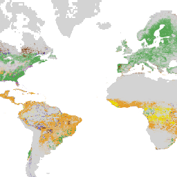
The SBTN Natural Lands Map provides a 2020 baseline of natural and non-natural land covers for companies setting science-based targets for nature, specifically aiming for no conversion of natural ecosystems.
-
The Aqueduct 4.0 framework offers intuitive indicators of water-related risk by curating 13 water risk indicators for quantity, quality, and reputational concerns.
-
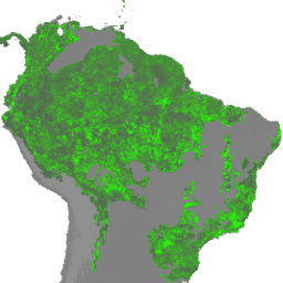
FORMA Alert Thresholds
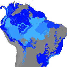
NOTE from WRI: WRI decided to stop updating FORMA alerts. The goal was to simplify the Global Forest Watch user experience and reduce redundancy. We found that Terra-i and GLAD were more frequently used. Moreover, using GLAD as a standard, found that Terra-i outperformed FORMA … daily deforestation fire forest forma gfw -
FORMA Alerts
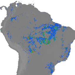
NOTE from WRI: WRI decided to stop updating FORMA alerts. The goal was to simplify the Global Forest Watch user experience and reduce redundancy. We found that Terra-i and GLAD were more frequently used. Moreover, using GLAD as a standard, found that Terra-i outperformed FORMA … daily deforestation fire forest forma gfw -
FORMA Raw Output FIRMS
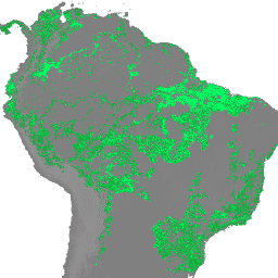
NOTE from WRI: WRI decided to stop updating FORMA alerts. The goal was to simplify the Global Forest Watch user experience and reduce redundancy. We found that Terra-i and GLAD were more frequently used. Moreover, using GLAD as a standard, found that Terra-i outperformed FORMA … daily deforestation fire forest forma gfw -
FORMA Raw Output NDVI
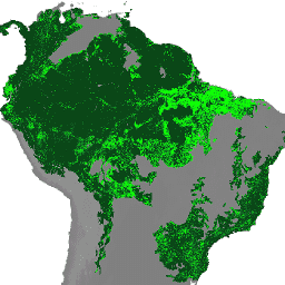
NOTE from WRI: WRI decided to stop updating FORMA alerts. The goal was to simplify the Global Forest Watch user experience and reduce redundancy. We found that Terra-i and GLAD were more frequently used. Moreover, using GLAD as a standard, found that Terra-i outperformed FORMA … daily deforestation forest forest-biomass forma gfw -
FORMA Vegetation T-Statistics
NOTE from WRI: WRI decided to stop updating FORMA alerts. The goal was to simplify the Global Forest Watch user experience and reduce redundancy. We found that Terra-i and GLAD were more frequently used. Moreover, using GLAD as a standard, found that Terra-i outperformed FORMA … daily deforestation forest forest-biomass forma gfw -
Global Power Plant Database
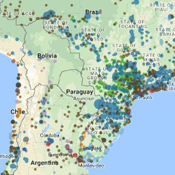
The Global Power Plant Database is a comprehensive, open source database of power plants around the world. It centralizes power plant data to make it easier to navigate, compare and draw insights. Each power plant is geolocated and entries contain information on plant capacity, generation, … infrastructure-boundaries table wri -
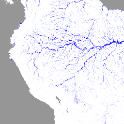
JRC Global River Flood Hazard Maps Version 2.1
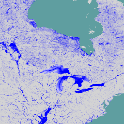
The global river flood hazard maps are a gridded data set representing inundation along the river network, for seven different flood return periods (from 1-in-10-years to 1-in-500-years). The input river flow data for the new maps are produced by means of the open-source hydrological model … flood monitoring surface-ground-water wri -
SBTN Natural Lands Map v1
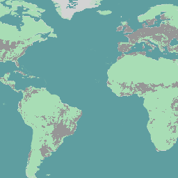
The SBTN Natural Lands Map v1 is a 2020 baseline map of natural and non-natural land covers intended for use by companies setting science-based targets for nature, specifically the SBTN Land target #1: no conversion of natural ecosystems. "Natural" and "non-natural" definitions were adapted from … ecosystems landcover landuse-landcover wri -
SBTN Natural Lands Map v1.1
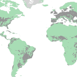
The SBTN Natural Lands Map v1.1 is a 2020 baseline map of natural and non-natural land covers intended for use by companies setting science-based targets for nature, specifically the SBTN Land target #1: no conversion of natural ecosystems. "Natural" and "non-natural" definitions were adapted from … ecosystems landcover landuse-landcover wri -
WRI Aqueduct Baseline Annual Version 4.0
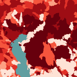
Aqueduct 4.0 is the latest iteration of WRI's water risk framework designed to translate complex hydrological data into intuitive indicators of water related risk. This dataset has curated 13 water risk indicators for quantity, quality and reputational concerns into a comprehensive framework. For 5 of … aqueduct flood monitoring surface-ground-water table wri -
WRI Aqueduct Baseline Monthly Version 4.0

Aqueduct 4.0 is the latest iteration of WRI's water risk framework designed to translate complex hydrological data into intuitive indicators of water related risk. This dataset has curated 13 water risk indicators for quantity, quality and reputational concerns into a comprehensive framework. For 5 of … aqueduct flood monitoring surface-ground-water table wri -
WRI Aqueduct Floods Hazard Maps Version 2
Aqueduct Floods data measures riverine and coastal food risks under both current baseline conditions and future projections in 2030, 2050, and 2080. In addition to providing hazard maps and assessing risks, Aqueduct Floods helps to conduct comprehensive cost-benefit analysis to evaluate the value of dike … flood monitoring surface-ground-water wri -
WRI Aqueduct Future Annual Version 4.0
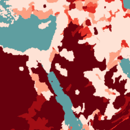
Aqueduct 4.0 is the latest iteration of WRI's water risk framework designed to translate complex hydrological data into intuitive indicators of water related risk. This dataset has curated 13 water risk indicators for quantity, quality and reputational concerns into a comprehensive framework. For 5 of … aqueduct flood monitoring surface-ground-water table wri -
WRI/Google DeepMind Global Drivers of Forest Loss 2001-2022 v1.0

This dataset maps the dominant driver of tree cover loss from 2001-2022 globally at 1 km resolution. Produced by the World Resources Institute (WRI) and Google DeepMind, the data were developed using a global neural network model (ResNet) trained on a set of samples collected … agriculture deforestation forest forest-biomass google landandcarbon -
WRI/Google DeepMind Global Drivers of Forest Loss 2001-2023 v1.1

This dataset maps the dominant driver of tree cover loss from 2001-2023 globally at 1 km resolution. Produced by the World Resources Institute (WRI) and Google DeepMind, the data were developed using a global neural network model (ResNet) trained on a set of samples collected … agriculture deforestation forest forest-biomass google landandcarbon -
WRI/Google DeepMind Global Drivers of Forest Loss 2001-2024 v1.2

This dataset maps the dominant driver of tree cover loss from 2001-2024 globally at 1 km resolution. Produced by the World Resources Institute (WRI) and Google DeepMind, the data were developed using a global neural network model (ResNet) trained on a set of samples collected … agriculture deforestation forest forest-biomass google landandcarbon -
WRI/Google DeepMind Global Drivers of Forest Loss 2001-2025 v1.3
This dataset maps the dominant driver of tree cover loss from 2001-2025 globally at 1 km resolution. Produced by the World Resources Institute (WRI) and Google DeepMind, the data were developed using a global neural network model (ResNet) trained on a set of samples collected … agriculture deforestation forest forest-biomass google landandcarbon