Page Summary
-
The Cote d'Ivoire BNETD 2020 Land Cover Map provides a detailed land cover map of Cote d'Ivoire produced by a national institution with technical and financial support from the European Union.
-
Several FORMA alert datasets, including FORMA Alert Thresholds, FORMA Alerts, FORMA Raw Output FIRMS, FORMA Raw Output NDVI, and FORMA Vegetation T-Statistics, have stopped being updated by WRI to simplify the user experience and reduce redundancy.
-
The Forest Persistence v0 dataset indicates whether a pixel area was occupied by undisturbed forest in 2020 with a per-pixel score.
-
Natural Forests of the World 2020 offers a global map of natural forest probability for 2020 at a 10-meter resolution, supporting forest conservation initiatives.
-
WRI/Google DeepMind provides datasets mapping the dominant driver of tree cover loss globally at 1 km resolution for the periods 2001-2022, 2001-2023, and 2001-2024.
-
Brazil Forest Imagery Dataset 2008: Visual Basemap
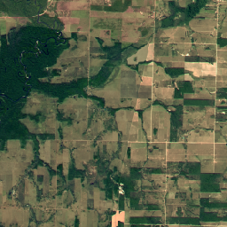
This dataset provides a visual imagery basemap of Brazil with up to 5-meter resolution, primarily captured in 2008, to support implementation of the Brazil Forest Code. The mosaic is synthesized from SPOT 2, 4, and 5 satellite data. It serves as a high-resolution alternative to … brazil deforestation forest-code google rgb satellite-imagery -
Cote d'Ivoire BNETD 2020 Land Cover Map
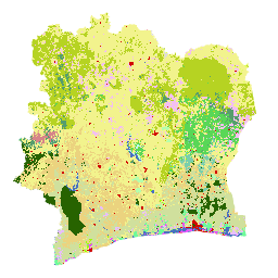
The Cote d'Ivoire BNETD 2020 Land Cover Map was produced by the Ivorian Government through a national institution, the Center for Geographic Information and Digital from the National Study Office Techniques and Development (BNETD-CIGN), with technical and financial support from the European Union. The methodology … classification deforestation forest landcover landuse-landcover -
FORMA Alert Thresholds
NOTE from WRI: WRI decided to stop updating FORMA alerts. The goal was to simplify the Global Forest Watch user experience and reduce redundancy. We found that Terra-i and GLAD were more frequently used. Moreover, using GLAD as a standard, found that Terra-i outperformed FORMA … daily deforestation fire forest forma gfw -
FORMA Alerts
NOTE from WRI: WRI decided to stop updating FORMA alerts. The goal was to simplify the Global Forest Watch user experience and reduce redundancy. We found that Terra-i and GLAD were more frequently used. Moreover, using GLAD as a standard, found that Terra-i outperformed FORMA … daily deforestation fire forest forma gfw -
FORMA Raw Output FIRMS
NOTE from WRI: WRI decided to stop updating FORMA alerts. The goal was to simplify the Global Forest Watch user experience and reduce redundancy. We found that Terra-i and GLAD were more frequently used. Moreover, using GLAD as a standard, found that Terra-i outperformed FORMA … daily deforestation fire forest forma gfw -
FORMA Raw Output NDVI
NOTE from WRI: WRI decided to stop updating FORMA alerts. The goal was to simplify the Global Forest Watch user experience and reduce redundancy. We found that Terra-i and GLAD were more frequently used. Moreover, using GLAD as a standard, found that Terra-i outperformed FORMA … daily deforestation forest forest-biomass forma gfw -
FORMA Vegetation T-Statistics
NOTE from WRI: WRI decided to stop updating FORMA alerts. The goal was to simplify the Global Forest Watch user experience and reduce redundancy. We found that Terra-i and GLAD were more frequently used. Moreover, using GLAD as a standard, found that Terra-i outperformed FORMA … daily deforestation forest forest-biomass forma gfw -
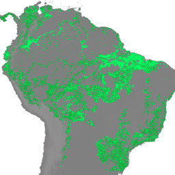
Forest Persistence v0

This image provides a per-pixel score (in [0, 1]) that indicates whether the pixel area is occupied by undisturbed forest in year 2020. These scores are provided at 30 meter resolution, and have been generated by a convergence of evidence approach to combining multiple forest … biodiversity conservation deforestation eudr forest-biomass forestdatapartnership -
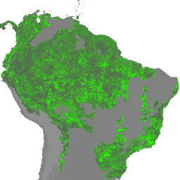
Forest Typology (ForTy) 2020 v1.0

The Forest Typology (ForTy) v1 dataset consists of a global per-class probability map at 10 m resolution covering all land areas between 65°S and 84°N latitude for the year 2020. The six-class typology is aligned with FAO and EU Deforestation Regulation (EUDR) definitions: Class 1 … alphaearth-derived biodiversity climate conservation deforestation eudr -
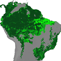
Natural Forests of the World 2020

Natural Forests of the World 2020, provides a global map of natural forest probability for the year 2020 at a 10-meter resolution. It was developed to support initiatives like the European Union's Deforestation Regulation (EUDR) and other efforts for forest conservation and monitoring. The map … biodiversity climate conservation deforestation eudr forest -
WRI/Google DeepMind Global Drivers of Forest Loss 2001-2022 v1.0

This dataset maps the dominant driver of tree cover loss from 2001-2022 globally at 1 km resolution. Produced by the World Resources Institute (WRI) and Google DeepMind, the data were developed using a global neural network model (ResNet) trained on a set of samples collected … agriculture deforestation forest forest-biomass google landandcarbon -
WRI/Google DeepMind Global Drivers of Forest Loss 2001-2023 v1.1

This dataset maps the dominant driver of tree cover loss from 2001-2023 globally at 1 km resolution. Produced by the World Resources Institute (WRI) and Google DeepMind, the data were developed using a global neural network model (ResNet) trained on a set of samples collected … agriculture deforestation forest forest-biomass google landandcarbon -
WRI/Google DeepMind Global Drivers of Forest Loss 2001-2024 v1.2

This dataset maps the dominant driver of tree cover loss from 2001-2024 globally at 1 km resolution. Produced by the World Resources Institute (WRI) and Google DeepMind, the data were developed using a global neural network model (ResNet) trained on a set of samples collected … agriculture deforestation forest forest-biomass google landandcarbon -
WRI/Google DeepMind Global Drivers of Forest Loss 2001-2025 v1.3
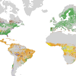
This dataset maps the dominant driver of tree cover loss from 2001-2025 globally at 1 km resolution. Produced by the World Resources Institute (WRI) and Google DeepMind, the data were developed using a global neural network model (ResNet) trained on a set of samples collected … agriculture deforestation forest forest-biomass google landandcarbon