
ฟังก์ชัน PLACES_COUNT จะแสดงผลค่าการนับเดียวของสถานที่ตามพื้นที่ค้นหาและตัวกรองการค้นหาที่ระบุ
คุณต้องระบุพื้นที่ค้นหาให้กับฟังก์ชัน PLACES_COUNT และระบุพารามิเตอร์ตัวกรองเพิ่มเติมได้โดยไม่บังคับ เช่น ประเภทสถานที่ สถานะการดำเนินงาน ระดับราคา และอื่นๆ
เนื่องจากฟังก์ชัน PLACES_COUNT แสดงผลค่าเดียว ให้เรียกใช้โดยใช้
คําสั่ง SELECT
พารามิเตอร์อินพุต
ต้องระบุ:
geographyพารามิเตอร์ตัวกรองที่ ระบุพื้นที่การค้นหา พารามิเตอร์geographyจะใช้ค่าที่กำหนด โดยประเภทข้อมูล BigQueryGEOGRAPHYซึ่งรองรับจุด เส้น และรูปหลายเหลี่ยมไม่บังคับ: พารามิเตอร์ตัวกรองเพิ่มเติมเพื่อปรับแต่งการค้นหา
ค่าที่ส่งคืน:
- ค่า
countเดียวเป็นINT64
- ค่า
ตัวอย่าง: คำนวณจำนวนสถานที่ในรัศมีการค้นหา
การเรียกใช้ฟังก์ชัน PLACES_COUNT ที่ง่ายที่สุดจะแสดงผลจำนวนสถานที่ทั้งหมด
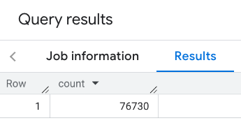
ในพื้นที่ทางภูมิศาสตร์ ในตัวอย่างนี้ คุณจะแสดงผลจำนวนสถานที่ที่เปิดให้บริการทั้งหมด
ภายในรัศมี 1, 000 เมตรจากตึกเอ็มไพร์สเตต
ตัวอย่างนี้ใช้ฟังก์ชัน BigQuery
ST_GEOGPOINT
เพื่อแสดงค่า GEOGRAPHY จากจุด
SELECT `PROJECT_NAME.places_insights___us.PLACES_COUNT`(
  JSON_OBJECT(
      'geography', ST_GEOGPOINT(-73.9857, 40.7484), -- Empire State Building
      'geography_radius', 1000 -- Radius in meters
      )
) as count;
การตอบกลับจะมีจำนวนเดียวดังนี้
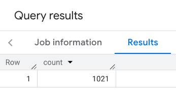
การเรียกที่พบบ่อยกว่าจะใช้ตัวกรองกับพื้นที่ค้นหา ตัวอย่างถัดไปใช้ ตัวกรองเพื่อจำกัดการค้นหาให้แสดงผลเฉพาะจำนวนต่อไปนี้
- สถานที่ประเภท
restaurantที่มีคะแนนขั้นต่ำ 3 - มีระดับราคาที่ไม่แพงหรือปานกลาง
- ใช้งานได้ในปัจจุบัน
- นำสุนัขเข้าได้
SELECT `PROJECT_NAME.places_insights___us.PLACES_COUNT`(
  JSON_OBJECT(
      'geography', ST_GEOGPOINT(-73.9857, 40.7484), -- Empire State Building
      'geography_radius', 1000, -- Radius in meters
      'types', ["restaurant"],
      'min_rating', 3,
      'price_level', ['PRICE_LEVEL_INEXPENSIVE', 'PRICE_LEVEL_MODERATE'],
      'business_status', ['OPERATIONAL'],
      'allows_dogs', TRUE
      )
) as count;
คำตอบที่กรองแล้ว
โปรดทราบว่าการค้นหาชุดข้อมูลสถานที่บังคับใช้เกณฑ์จำนวนขั้นต่ำที่ 5 ข้อดีอย่างหนึ่งของฟังก์ชันการนับสถานที่คือ ฟังก์ชันนี้จะแสดงผลการนับใดก็ได้ รวมถึง 0 ตัวอย่างเช่น การเรียกใช้ต่อไปนี้ จะแสดงผลการนับเป็น 1
SELECT `PROJECT_NAME.places_insights___us.PLACES_COUNT`(
  JSON_OBJECT(
      'geography', ST_GEOGPOINT(-73.9857, 40.7484), -- Empire State Building
      'geography_radius', 500, -- Radius in meters
      'types', ["restaurant"],
      'min_rating', 4.0,
      'free_parking_lot', TRUE,
      'good_for_watching_sports', TRUE
      )
) as count;
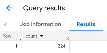
ตัวอย่าง: คำนวณจำนวนร้านอาหารโดยใช้รูปหลายเหลี่ยม
คุณใช้รูปหลายเหลี่ยมเพื่อระบุพื้นที่ค้นหาได้ เมื่อใช้รูปหลายเหลี่ยม จุดของรูปหลายเหลี่ยมต้องกำหนดลูปปิดโดยที่จุดแรกใน รูปหลายเหลี่ยมต้องเหมือนกับจุดสุดท้าย
ตัวอย่างนี้ใช้ฟังก์ชัน BigQuery
ST_GEOGFROMTEXT
เพื่อแสดงผลค่า GEOGRAPHY จากรูปหลายเหลี่ยม
DECLARE geo GEOGRAPHY;
SET geo = ST_GEOGFROMTEXT('''POLYGON((-73.985708 40.75773,-73.993324 40.750298,
                                      -73.9857 40.7484,-73.9785 40.7575,
                                      -73.985708 40.75773))''');  -- NYC viewport

SELECT `PROJECT_NAME.places_insights___us.PLACES_COUNT`(
  JSON_OBJECT(
      'geography',geo, -- viewport
      'types', ["restaurant"],
      'min_rating', 1.0,
      'max_rating', 4.5,
      'min_user_rating_count', 1,
      'max_user_rating_count', 10000,
      'price_level', ['PRICE_LEVEL_INEXPENSIVE', 'PRICE_LEVEL_MODERATE'],
      'business_status', ['OPERATIONAL'],
      'allows_dogs', TRUE
      )
) as count;
การตอบกลับสำหรับวิวพอร์ต
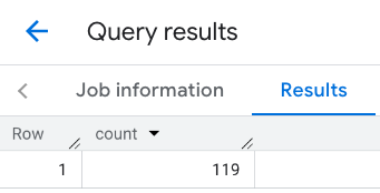
ตัวอย่าง: คำนวณจำนวนร้านอาหารโดยใช้เส้น
ในตัวอย่างถัดไป คุณจะกำหนดพื้นที่ค้นหาโดยใช้เส้นของจุดที่เชื่อมต่อกัน โดยมีรัศมีการค้นหา 100 เมตรรอบเส้น เส้นทางนี้คล้ายกับเส้นทางการเดินทางที่คำนวณโดย Routes API เส้นทางอาจเป็นเส้นทางสำหรับยานพาหนะ จักรยาน หรือคนเดินเท้า
DECLARE geo GEOGRAPHY;
SET geo = ST_GEOGFROMTEXT('LINESTRING(-73.98903537033028 40.73655649223003,-73.93580216278471 40.80955538843361)');  -- NYC line

SELECT `PROJECT_NAME.places_insights___us.PLACES_COUNT`(
  JSON_OBJECT(
      'geography',geo, -- line
      'geography_radius', 100, -- Radius around line
      'types', ["restaurant"],
      'min_rating', 1.0,
      'max_rating', 4.5,
      'min_user_rating_count', 1,
      'max_user_rating_count', 10000,
      'price_level', ['PRICE_LEVEL_INEXPENSIVE', 'PRICE_LEVEL_MODERATE'],
      'business_status', ['OPERATIONAL'],
      'allows_dogs', TRUE
      )
) as count;
คำตอบสำหรับบรรทัดนี้
ตัวอย่าง: รวมผลลัพธ์ของการเรียกหลายครั้ง
คุณรวมผลลัพธ์ของการเรียกใช้หลายครั้งเข้ากับฟังก์ชัน PLACES_COUNT ได้
เช่น คุณต้องการผลลัพธ์เดียวที่แสดงจำนวนร้านอาหารสำหรับ
ระดับราคาต่อไปนี้ภายในพื้นที่ที่เฉพาะเจาะจง
PRICE_LEVEL_INEXPENSIVEPRICE_LEVEL_MODERATEPRICE_LEVEL_EXPENSIVEPRICE_LEVEL_VERY_EXPENSIVE"
ในตัวอย่างนี้ คุณจะสร้างลูปเพื่อเรียกใช้ฟังก์ชัน PLACES_COUNT สำหรับระดับราคาแต่ละระดับ
และแทรกผลลัพธ์ของการเรียกแต่ละครั้งลงในตารางชั่วคราว จากนั้นคุณจะ
ค้นหาตารางชั่วคราวเพื่อแสดงผลลัพธ์ได้
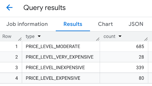
-- Create a temp table to hold the results.
CREATE TEMP TABLE results (type STRING, count INT64);

-- Create a loop that calls PLACES_COUNT for each price level.
FOR types IN (SELECT type FROM UNNEST(["PRICE_LEVEL_INEXPENSIVE", "PRICE_LEVEL_MODERATE", "PRICE_LEVEL_EXPENSIVE", "PRICE_LEVEL_VERY_EXPENSIVE"]) as type)
DO
  INSERT INTO results VALUES (types.type, `PROJECT_NAME.places_insights___us.PLACES_COUNT`(
  JSON_OBJECT(
      'types', ["restaurant"],
      'geography', ST_GEOGPOINT(-73.9857, 40.7484), -- Empire State Building
      'geography_radius', 1000, -- Radius in meters
      'business_status', ['OPERATIONAL'],
      'price_level', [types.type]
  )));
END FOR;

-- Query the table of results.
SELECT * FROM results;
คำตอบที่รวมกัน
อีกตัวเลือกหนึ่งคือการใช้คำสั่ง UNION ALL เพื่อรวมผลลัพธ์ของคำสั่ง SELECT หลายรายการ ตัวอย่างต่อไปนี้แสดงผลลัพธ์เดียวกันกับ
ตัวอย่างก่อนหน้า
SELECT "PRICE_LEVEL_INEXPENSIVE" as price_level, `PROJECT_NAME.places_insights___us.PLACES_COUNT`(
  JSON_OBJECT(
      'types', ["restaurant"],
      'geography', ST_GEOGPOINT(-73.9857, 40.7484), -- Empire State Building
      'geography_radius', 1000, -- Radius in meters
      'business_status', ['OPERATIONAL'],
      'price_level', ['PRICE_LEVEL_INEXPENSIVE']
  )
) as count

UNION ALL

SELECT "PRICE_LEVEL_MODERATE" as price_level, `PROJECT_NAME.places_insights___us.PLACES_COUNT`(
  JSON_OBJECT(
      'types', ["restaurant"],
      'geography', ST_GEOGPOINT(-73.9857, 40.7484), -- Empire State Building
      'geography_radius', 1000, -- Radius in meters
      'business_status', ['OPERATIONAL'],
      'price_level', ['PRICE_LEVEL_MODERATE']
  )
) as count

UNION ALL

SELECT "PRICE_LEVEL_EXPENSIVE" as price_level, `PROJECT_NAME.places_insights___us.PLACES_COUNT`(
  JSON_OBJECT(
      'types', ["restaurant"],
      'geography', ST_GEOGPOINT(-73.9857, 40.7484), -- Empire State Building
      'geography_radius', 1000, -- Radius in meters
      'business_status', ['OPERATIONAL'],
      'price_level', ['PRICE_LEVEL_EXPENSIVE']
  )
) as count

UNION ALL

SELECT "PRICE_LEVEL_VERY_EXPENSIVE" as price_level, `PROJECT_NAME.places_insights___us.PLACES_COUNT`(
  JSON_OBJECT(
      'types', ["restaurant"],
      'geography', ST_GEOGPOINT(-73.9857, 40.7484), -- Empire State Building
      'geography_radius', 1000, -- Radius in meters
      'business_status', ['OPERATIONAL'],
      'price_level', ['PRICE_LEVEL_VERY_EXPENSIVE']
  )
) as count