-
ESA WorldCereal 10 m v100

欧州宇宙機関(ESA)の WorldCereal 10 m 2021 プロダクト スイートは、グローバル規模の年間および季節ごとの作物地図と、それに関連する信頼度で構成されています。これらは ESA-WorldCereal プロジェクトの一環として生成されました。これらのプロダクトの内容と、…に使用される方法の詳細 農業 copernicus 作物 esa グローバル 土地被覆 -
ESA WorldCereal Active Cropland 10 m v100

欧州宇宙機関(ESA)の WorldCereal Active Cropland 10 m 2021 プロダクト スイートには、グローバル スケールの季節ごとのアクティブな農地のマーカーが含まれています。これらは ESA-WorldCereal プロジェクトの一環として生成されました。アクティブな農地プロダクトは、一時的な作物として識別されたピクセルがアクティブに… 農業 copernicus 作物 esa グローバル 土地被覆 -
ESA WorldCover 10m v100
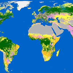
欧州宇宙機関(ESA)の WorldCover 10 m 2020 プロダクトは、Sentinel-1 と Sentinel-2 のデータに基づいて、2020 年の全球の土地被覆マップを 10 m の解像度で提供します。WorldCover プロダクトには 11 の土地被覆クラスがあり、… のフレームワークで生成されています。 esa landcover landuse landuse-landcover sentinel1-derived sentinel2-derived -
ESA WorldCover 10m v200

欧州宇宙機関(ESA)の WorldCover 10 m 2021 プロダクトは、Sentinel-1 と Sentinel-2 のデータに基づいて、2021 年のグローバルな土地被覆マップを 10 m の解像度で提供します。WorldCover プロダクトには 11 の土地被覆クラスがあり、… のフレームワークで生成されています。 esa landcover landuse landuse-landcover sentinel1-derived sentinel2-derived -
EUCROPMAP
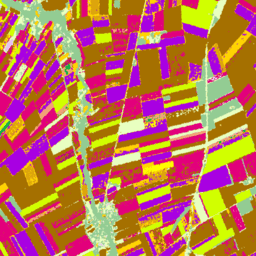
2018 年の Sentinel-1 と LUCAS Copernicus 2018 の現地観測、2022 年の Sentinel-1、Sentinel-2、補助データと LUCAS Copernicus 2022 の観測を組み合わせて作成された、ヨーロッパの作物タイプマップ。このデータセットは、独自の LUCAS 2018 Copernicus 現地調査に基づいており、… agriculture crop eu jrc lucas sentinel1-derived -
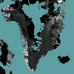
Global Seasonal Sentinel-1 Interferometric Coherence and Backscatter V2019 Backscatter
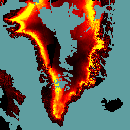
このデータセットは、多季節のグローバル C バンド合成開口レーダー(SAR)干渉計の繰り返しパス コヒーレンスと後方散乱シグネチャを空間的に表現した初のデータセットです。この範囲には、北緯 82 度から南緯 79 度までの陸地と氷床が含まれます。データセットは、マルチテンポラル… backscatter earth-big-data jpl nasa polarization radar -
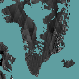
Global Seasonal Sentinel-1 Interferometric Coherence and Backscatter V2019 Coherence
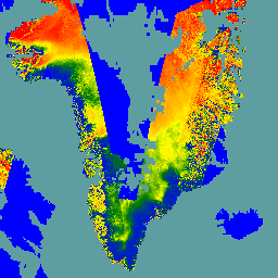
このデータセットは、多季節のグローバル C バンド合成開口レーダー(SAR)干渉計の繰り返しパス コヒーレンスと後方散乱シグネチャを空間的に表現した初のデータセットです。この範囲には、北緯 82 度から南緯 79 度までの陸地と氷床が含まれます。データセットは、マルチテンポラル… earth-big-data jpl nasa polarization radar sar -
Global Seasonal Sentinel-1 Interferometric Coherence and Backscatter V2019 Decay Model Parameters
このデータセットは、多季節のグローバル C バンド合成開口レーダー(SAR)干渉計の繰り返しパス コヒーレンスと後方散乱シグネチャを空間的に表現した初のデータセットです。この範囲には、北緯 82 度から南緯 79 度までの陸地と氷床が含まれます。データセットは、マルチテンポラル… earth-big-data jpl nasa polarization radar sar -
Global Seasonal Sentinel-1 Interferometric Coherence and Backscatter V2019 Incidence Layover Shadow
このデータセットは、多季節のグローバル C バンド合成開口レーダー(SAR)干渉計の繰り返しパス コヒーレンスと後方散乱シグネチャを空間的に表現した初のデータセットです。この範囲には、北緯 82 度から南緯 79 度までの陸地と氷床が含まれます。データセットは、マルチテンポラル… earth-big-data jpl nasa polarization radar sar -
Satellite Embedding V1
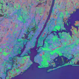
Google Satellite Embedding データセットは、学習済みの地理空間エンベディングのグローバルな分析対応コレクションです。このデータセットの各 10 メートルのピクセルは、さまざまな地球観測によって測定された、そのピクセルとその周辺の地表状態の時間的軌跡をエンコードする 64 次元の表現(エンベディング ベクトル)です。 annual global google landsat-derived satellite-imagery sentinel1-derived -
World Settlement Footprint 2015
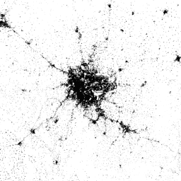
World Settlement Footprint(WSF)2015 は、2014 ~ 2015 年のマルチテンポラル Landsat-8 および Sentinel-1 画像(それぞれ約 217,000 シーンと約 107,000 シーンが処理済み)を使用して、世界中の人間の居住地の範囲を 10 メートルの解像度で示すバイナリ マスクです。人間の居住地の時間的動態… landcover landsat-derived population sentinel1-derived settlement urban>