- データセットの利用可能な期間
- 2020-01-01T00:00:00Z–2021-01-01T00:00:00Z
- データセット プロデューサー
- ESA WorldCover コンソーシアム
- タグ
説明
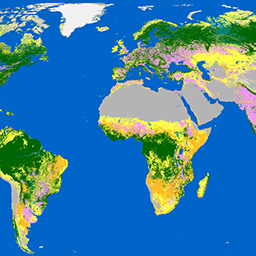
欧州宇宙機関(ESA)の WorldCover 10 m 2020 プロダクトは、Sentinel-1 と Sentinel-2 のデータに基づいて、2020 年の全球の土地被覆マップを 10 m の解像度で提供します。WorldCover プロダクトには 11 個の土地被覆クラスが含まれており、欧州宇宙機関の第 5 回地球観測エンベロープ プログラム(EOEP-5)の一環である ESA WorldCover プロジェクトの枠組みで生成されています。
関連項目:
バンド
ピクセルサイズ
10 メートル
バンド
| 名前 | ピクセルサイズ | 説明 |
|---|---|---|
Map |
メートル | 土地被覆クラス |
マップクラス テーブル
| 値 | 色 | 説明 |
|---|---|---|
| 10 | #006400 | 樹木エリア |
| 20 | #ffbb22 | 低木地 |
| 30 | #ffff4c | 草原 |
| 40 | #f096ff | 耕作地 |
| 50 | #fa0000 | 人工建造物 |
| 60 | #b4b4b4 | 植生がまばらな土地 |
| 70 | #f0f0f0 | 雪と氷 |
| 80 | #0064c8 | 恒久的な水域 |
| 90 | #0096a0 | 草本湿地 |
| 95 | #00cf75 | マングローブ |
| 100 | #fae6a0 | コケと地衣類 |
利用規約
利用規約
引用
引用:
Zanaga, D.、Van De Kerchove, R.、De Keersmaecker, W.、Souverijns, N.、Brockmann, C.、Quast, R.、Wevers, J.、Grosu, A.、Paccini, A.、Vergnaud, S.、Cartus, O.、Santoro, M.、Fritz, S.、Georgieva, I.、Lesiv, M.、Carter, S.、Herold, M.、Li, Linlin, Tsendbazar, N.E., Ramoino, F.、Arino, O.、2021 年。 ESA WorldCover 10 m 2020 v100。(doi:10.5281/zenodo.5571936)
Earth Engine で探索する
コードエディタ(JavaScript)
var dataset = ee.ImageCollection('ESA/WorldCover/v100').first();

var visualization = {
  bands: ['Map'],
};

Map.centerObject(dataset);

Map.addLayer(dataset, visualization, 'Landcover');
import ee
import geemap.core as geemap
Colab(Python)
dataset = ee.ImageCollection('ESA/WorldCover/v100').first()

visualization = {
    'bands': ['Map'],
}

m = geemap.Map()
m.center_object(dataset)
m.add_layer(dataset, visualization, 'Landcover')
m