Page Summary
-
Cloud and Moisture Imagery products are available for GOES-16, GOES-17, GOES-18, and GOES-19 satellites.
-
These products provide imagery at a 2km resolution for CONUS, Full Disk, and Mesoscale views.
-
Bands 1-6 are reflective, supporting the characterization of clouds, vegetation, snow/ice, and aerosols.
-
Bands 7-16 are emissive, providing brightness temperature data.
-
GOES-16 MCMIPC Series ABI Level 2 Cloud and Moisture Imagery CONUS
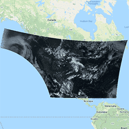
The Cloud and Moisture Imagery products are all at 2km resolution. Bands 1-6 are reflective. The dimensionless "reflectance factor" quantity is normalized by the solar zenith angle. These bands support the characterization of clouds, vegetation, snow/ice, and aerosols. Bands 7-16 are emissive. The brightness temperature … abi atmosphere goes goes-16 goes-east goes-r -
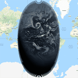
GOES-16 MCMIPF Series ABI Level 2 Cloud and Moisture Imagery Full Disk
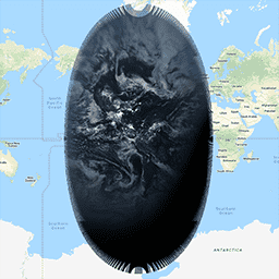
The Cloud and Moisture Imagery products are all at 2km resolution. Bands 1-6 are reflective. The dimensionless "reflectance factor" quantity is normalized by the solar zenith angle. These bands support the characterization of clouds, vegetation, snow/ice, and aerosols. Bands 7-16 are emissive. The brightness temperature … abi atmosphere goes goes-16 goes-east goes-r -
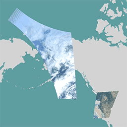
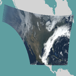
GOES-16 MCMIPM Series ABI Level 2 Cloud and Moisture Imagery Mesoscale
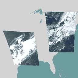
The Cloud and Moisture Imagery products are all at 2km resolution. Bands 1-6 are reflective. The dimensionless "reflectance factor" quantity is normalized by the solar zenith angle. These bands support the characterization of clouds, vegetation, snow/ice, and aerosols. Bands 7-16 are emissive. The brightness temperature … abi atmosphere goes goes-16 goes-east goes-r -
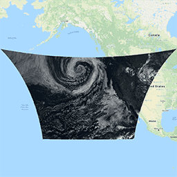
GOES-17 MCMIPC Series ABI Level 2 Cloud and Moisture Imagery CONUS

The Cloud and Moisture Imagery products are all at 2km resolution. Bands 1-6 are reflective. The dimensionless "reflectance factor" quantity is normalized by the solar zenith angle. These bands support the characterization of clouds, vegetation, snow/ice, and aerosols. Bands 7-16 are emissive. The brightness temperature … abi atmosphere goes goes-17 goes-s mcmip -
GOES-17 MCMIPF Series ABI Level 2 Cloud and Moisture Imagery Full Disk

The Cloud and Moisture Imagery products are all at 2km resolution. Bands 1-6 are reflective. The dimensionless "reflectance factor" quantity is normalized by the solar zenith angle. These bands support the characterization of clouds, vegetation, snow/ice, and aerosols. Bands 7-16 are emissive. The brightness temperature … abi atmosphere goes goes-17 goes-s mcmip -
GOES-17 MCMIPM Series ABI Level 2 Cloud and Moisture Imagery Mesoscale

The Cloud and Moisture Imagery products are all at 2km resolution. Bands 1-6 are reflective. The dimensionless "reflectance factor" quantity is normalized by the solar zenith angle. These bands support the characterization of clouds, vegetation, snow/ice, and aerosols. Bands 7-16 are emissive. The brightness temperature … abi atmosphere goes goes-17 goes-s mcmip -
GOES-18 MCMIPC Series ABI Level 2 Cloud and Moisture Imagery CONUS
The Cloud and Moisture Imagery products are all at 2km resolution. Bands 1-6 are reflective. The dimensionless "reflectance factor" quantity is normalized by the solar zenith angle. These bands support the characterization of clouds, vegetation, snow/ice, and aerosols. Bands 7-16 are emissive. The brightness temperature … abi atmosphere goes goes-18 goes-t goes-west -
GOES-18 MCMIPF Series ABI Level 2 Cloud and Moisture Imagery Full Disk
The Cloud and Moisture Imagery products are all at 2km resolution. Bands 1-6 are reflective. The dimensionless "reflectance factor" quantity is normalized by the solar zenith angle. These bands support the characterization of clouds, vegetation, snow/ice, and aerosols. Bands 7-16 are emissive. The brightness temperature … abi atmosphere goes goes-18 goes-t goes-west -
GOES-18 MCMIPM Series ABI Level 2 Cloud and Moisture Imagery Mesoscale
The Cloud and Moisture Imagery products are all at 2km resolution. Bands 1-6 are reflective. The dimensionless "reflectance factor" quantity is normalized by the solar zenith angle. These bands support the characterization of clouds, vegetation, snow/ice, and aerosols. Bands 7-16 are emissive. The brightness temperature … abi atmosphere goes goes-18 goes-t goes-west -
GOES-19 MCMIPC Series ABI Level 2 Cloud and Moisture Imagery CONUS
The Cloud and Moisture Imagery products are all at 2km resolution. Bands 1-6 are reflective. The dimensionless "reflectance factor" quantity is normalized by the solar zenith angle. These bands support the characterization of clouds, vegetation, snow/ice, and aerosols. Bands 7-16 are emissive. The brightness temperature … abi atmosphere goes goes-19 goes-east goes-u -
GOES-19 MCMIPF Series ABI Level 2 Cloud and Moisture Imagery Full Disk

The Cloud and Moisture Imagery products are all at 2km resolution. Bands 1-6 are reflective. The dimensionless "reflectance factor" quantity is normalized by the solar zenith angle. These bands support the characterization of clouds, vegetation, snow/ice, and aerosols. Bands 7-16 are emissive. The brightness temperature … abi atmosphere goes goes-19 goes-east goes-u -
GOES-19 MCMIPM Series ABI Level 2 Cloud and Moisture Imagery Mesoscale

The Cloud and Moisture Imagery products are all at 2km resolution. Bands 1-6 are reflective. The dimensionless "reflectance factor" quantity is normalized by the solar zenith angle. These bands support the characterization of clouds, vegetation, snow/ice, and aerosols. Bands 7-16 are emissive. The brightness temperature … abi atmosphere goes goes-19 goes-east goes-u