Page Summary
-
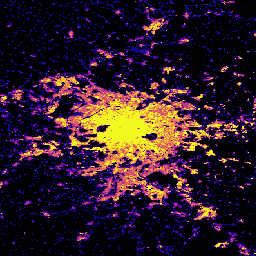
This dataset provides global building height distribution at 100m resolution for the year 2018, derived from ALOS, SRTM, and Sentinel-2 data.
-
The dataset is part of the Global Human Settlement Layer (GHSL) project, supported by the European Commission Joint Research Centre.
-
The data is open and free to use, with the requirement to acknowledge the source.
-
The dataset includes a single band representing average building height in meters per grid cell.
- Dataset Availability
- 2018-01-01T00:00:00Z–2018-12-31T00:00:00Z
- Dataset Producer
- EC JRC
- Tags
Description
This spatial raster dataset depicts the global distribution of building heights at a resolution of 100 m, referred to the year 2018. The input data used to predict building heights are the ALOS Global Digital Surface Model (30 m), the NASA Shuttle Radar Topographic Mission data (30 m), and a global Sentinel-2 image composite from L1C data for the period 2017-2018.
More information about the GHSL data products can be found in the GHSL Data Package 2023 report, where the building height layer is referred to as the Average Net Building Height (ANBH).
The Global Human Settlement Layer (GHSL) project is supported by the European Commission, Joint Research Centre, and Directorate-General for Regional and Urban Policy.
Bands
Bands
Pixel size: 100 meters (all bands)
| Name | Units | Pixel Size | Description |
|---|---|---|---|
built_height |
m | 100 meters | Average building height per grid cell |
Terms of Use
Terms of Use
The GHSL has been produced by the European Commission Joint Research Centre as open and free data. Reuse is authorised, provided the source is acknowledged. For more information, please read the use conditions (European Commission Reuse and Copyright Notice).
Citations
Dataset : Pesaresi, Martino; Politis, Panagiotis (2023): GHS-BUILT-H R2023A - GHS building height, derived from AW3D30, SRTM30, and Sentinel2 composite (2018). European Commission, Joint Research Centre (JRC) PID: http://data.europa.eu/89h/85005901-3a49-48dd-9d19-6261354f56fe doi:10.2905/85005901-3A49-48DD-9D19-6261354F56FE
Methodology : Pesaresi, Martino, Marcello Schiavina, Panagiotis Politis, Sergio Freire, Katarzyna Krasnodebska, Johannes H. Uhl, Alessandra Carioli, et al. (2024). Advances on the Global Human Settlement Layer by Joint Assessment of Earth Observation and Population Survey Data. International Journal of Digital Earth 17(1). doi:10.1080/17538947.2024.2390454.
DOIs
Explore with Earth Engine
Code Editor (JavaScript)
var image = ee.Image("JRC/GHSL/P2023A/GHS_BUILT_H/2018");
var built = image.select('built_height');
var visParams = {
  min: 0.0,
  max: 12.0,
  palette: ['000000', '0d0887', '7e03a8', 'cc4778', 'f89540', 'f0f921'],
};

Map.setCenter(2.349014, 48.864716, 10);
Map.addLayer(built, visParams, 'Average building height [m], 2018');