Page Summary
-
Global river flood hazard maps represent inundation along the river network for seven different flood return periods (10 to 500 years).
-
The dataset provides water depth information in meters for various return periods, enabling assessment of population and economic asset exposure to river floods.
-
Version 2.1 includes updated band structures with separate depth and depth category bands for each return period, plus permanent water class and spurious depth category bands.
-
This dataset is created as part of the Copernicus Emergency Management Service and is available without restriction on use or distribution.
- Dataset Availability
- 2024-03-16T00:00:00Z–2024-03-16T23:59:59Z
- Dataset Producer
- Joint Research Centre
- Tags
Description
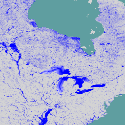
The global river flood hazard maps are a gridded data set representing inundation along the river network, for seven different flood return periods (from 1-in-10-years to 1-in-500-years). The input river flow data for the new maps are produced by means of the open-source hydrological model LISFLOOD, while inundation simulations are performed with the hydrodynamic model LISFLOOD-FP. The extent comprises the entire world with the exception of Greenland and Antarctica and small islands with river basins smaller than 500 km^2.
Cell values indicate water depth (in meters). The maps can be used to assess the exposure of population and economic assets to river floods, and to perform flood risk assessments. The dataset is created as part of the Copernicus Emergency Management Service.
This version also includes additional datasets. For each tile, a flood hazard map is available with water depth categorized according to the GloFAS "Flood hazard 100 year return period" static layer. Furthermore, the "spurious_depth_category" band identifies areas where depths greater than 10m are predicted in small channels (less than 3,000km^2) for the 10-year return period, including a 2km buffer.
Bands
Bands
Pixel size: 90 meters (all bands)
| Name | Units | Min | Max | Pixel Size | Description |
|---|---|---|---|---|---|
RP10_depth |
m | 0.1 | 160 | 90 meters | Flood inundation depth for return period 10 years |
RP20_depth |
m | 0.1 | 199 | 90 meters | Flood inundation depth for return period 20 years |
RP50_depth |
m | 0.1 | 258.1 | 90 meters | Flood inundation depth for return period 50 years |
RP75_depth |
m | 0.1 | 283.6 | 90 meters | Flood inundation depth for return period 75 years |
RP100_depth |
m | 0.1 | 301.6 | 90 meters | Flood inundation depth for return period 100 years |
RP200_depth |
m | 0.1 | 344.8 | 90 meters | Flood inundation depth for return period 200 years |
RP500_depth |
m | 0.1 | 401.3 | 90 meters | Flood inundation depth for return period 500 years |
RP10_depth_category |
2 | 4 | 90 meters | Water depth categorized as the GloFAS Flood hazard 100 year return period static layer for return period 10 years |
|
RP20_depth_category |
2 | 4 | 90 meters | Water depth categorized as the GloFAS Flood hazard 100 year return period static layer for return period 20 years |
|
RP50_depth_category |
2 | 4 | 90 meters | Water depth categorized as the GloFAS Flood hazard 100 year return period static layer for return period 50 years |
|
RP75_depth_category |
2 | 4 | 90 meters | Water depth categorized as the GloFAS Flood hazard 100 year return period static layer for return period 75 years |
|
RP100_depth_category |
2 | 4 | 90 meters | Water depth categorized as the GloFAS Flood hazard 100 year return period static layer for return period 100 years |
|
RP200_depth_category |
2 | 4 | 90 meters | Water depth categorized as the GloFAS Flood hazard 100 year return period static layer for return period 200 years |
|
RP500_depth_category |
2 | 4 | 90 meters | Water depth categorized as the GloFAS Flood hazard 100 year return period static layer for return period 500 years |
|
permanent_water_class |
1 | 1 | 90 meters | Permanent water bodies used to patch the flood hazard maps |
|
spurious_depth_category |
1 | 1 | 90 meters | Identifies areas where depths >10m are predicted in small channels (<3,000km^2) for the 10-year return period, plus a 2km buffer |
Image Properties
Image Properties
| Name | Type | Description |
|---|---|---|
| id | INT | Unique identifier for the latitude/longitude grid cell. |
Terms of Use
Terms of Use
The JRC datasets are available without restriction on use or distribution. For more information check access rights,
Citations
Baugh, Calum; Colonese, Juan; D'Angelo, Claudia; Dottori, Francesco; Neal, Jeffrey; Prudhomme, Christel; Salamon, Peter (2024): Global river flood hazard maps. European Commission, Joint Research Centre (JRC) [Dataset] PID: http://data.europa.eu/89h/jrc-floods-floodmapgl_rp50y-tif
DOIs
Explore with Earth Engine
Code Editor (JavaScript)
var dataset = ee.ImageCollection('JRC/CEMS_GLOFAS/FloodHazard/v2_1');
var depth = dataset.select('RP100_depth');
var depthVis = {
  min: 0,
  max: 1,
  palette: ['ffffff','0000ff'],
};
Map.setCenter(-86.47, 47.28, 4);
Map.addLayer(depth, depthVis, 'JRC Flood Hazard Maps V2.1');