Page Summary
-
The dataset provides NLS Orthophotos covering all of Finland, supplied by Mavi (Agency for Rural Affairs).
-
These orthophotos are a combination of multiple aerial photos and are usually 1-3 years old, updated every 3 years (or 12 years in Northern Lapland).
-
The images contain near-infrared, red, and green bands with a pixel size of 0.5 meters.
-
Usage requires mentioning the Licensor (National Land Survey of Finland), the dataset name, and the delivery time.
- Dataset Availability
- 2015-01-01T00:00:00Z–2018-01-01T00:00:00Z
- Dataset Producer
- NLS orthophotos
- Tags
Description
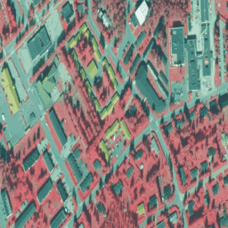
NLS Orthophotos are an aerial photo dataset covering the whole of Finland. This data is provided by Mavi(Agency for Rural Affairs). An orthophoto is a combination of several individual aerial photos. The aerial photo dataset in orthophoto format is available as the most recent dataset consisting of the most recent aerial photos available. The most recent data is usually 1-3 years old. NLS Orthophotos are updated every 3 years (in Northern Lapland 12 years).
In these images, the bands are near-infrared, red, and green.
(In Dataset id, VV stands for "vääräväri", false color) For more information, please see the NLS orthophotos documentation
Bands
Bands
Pixel size: 0.5 meters (all bands)
| Name | Min | Max | Pixel Size | Description |
|---|---|---|---|---|
N |
0 | 255 | 0.5 meters | Near-Infrared |
R |
0 | 255 | 0.5 meters | Red |
G |
0 | 255 | 0.5 meters | Green |
Terms of Use
Terms of Use
Mention the name of the Licensor (the National Land Survey of Finland), the name of the dataset(s) and the time when the National Land Survey has delivered the dataset(s) (e.g.: contains data from the National Land Survey of Finland Topographic Database 06/2014). please see the Terms of use
Citations
The National Land Survey of Finland
Explore with Earth Engine
Code Editor (JavaScript)
var dataset = ee.ImageCollection('Finland/MAVI/VV/50cm');

Map.setCenter(25.7416, 62.2446, 16);
Map.addLayer(dataset, null, 'Finland 50 cm(false color)');