رابط برنامهنویسی کاربردی Solar از دادههای مکانی برای تعیین نوع ساختمان استفاده میکند و ساختمانها را بر اساس تصاویر ماهوارهای شناسایی میکند. این صفحه نحوه تعیین اطلاعات خورشیدی کدام ساختمان را که در درخواست buildingInsights برگردانده میشود، شرح میدهد.
انواع ساختمان
API خورشیدی از ساختمانهایی از نوع premise پشتیبانی میکند. این نوع نشاندهنده یک مکان نامگذاری شده است که معمولاً یک ساختمان یا مجموعهای از ساختمانها با یک نام مشترک است.
انواع دیگر، مانند subpremise یا مجتمعها - برای مثال، ساختمانهای مجزا واقع در یک ملک واحد، مگر اینکه به عنوان یک premise ثبت شده باشند - پشتیبانی نمیشوند .
سقف ساختمان
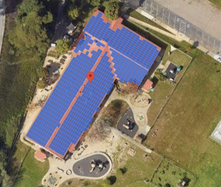
API خورشیدی، مکان بهینه قرارگیری پنلهای خورشیدی روی پشت بام را بر اساس تصاویر ماهوارهای شناسایی میکند. ساختمانهای مسکونی، به ویژه سقفهای شیبدار یا شیروانی، با دقت بالایی شناسایی میشوند، در حالی که ساختمانهای با سقف مسطح (به عنوان مثال، ساختمانهای آپارتمانی یا تجاری) ممکن است دقت متفاوتی داشته باشند.
اگر پاسخ buildingInsights شامل فیلد solarPanelConfigs نباشد، ساختمان به درستی پردازش شده است، اما ما نتوانستیم پنلها را روی سقف قرار دهیم. این ممکن است زمانی اتفاق بیفتد که سقف برای قرار دادن پنلها خیلی کوچک باشد یا برای پنلها خیلی سایهدار باشد تا انرژی قابل توجهی تولید کنند.
جستجو از یک آدرس
شما میتوانید با استفاده از API مربوط به Geocoding یا API مربوط به Place Autocomplete، یک آدرس را به مختصات طول و عرض جغرافیایی تبدیل کنید.
برای اشاره به مکان منطبق
place_idاستفاده کنید.از مختصات طول و عرض جغرافیایی مکان در درخواست
buildingInsightsAPI Solar خود استفاده کنید.- اگر Solar API ساختمان منطبقی پیدا کرد، بررسی کنید که
place_idدر پاسخbuildingInsightsباplace_idاز Geocoding API یا Place Autocomplete API مطابقت داشته باشد. - برای محدود کردن نتایج به مکانهایی با نوع
premise، یک فیلتر نوع مکان به پاسخهای Geocoding API یا Places API اضافه کنید.{ "name": "buildings/ChIJh0CMPQW7j4ARLrRiVvmg6Vs", "center": { "latitude": 37.4449739, "longitude": -122.13914659999998 },... }
- اگر Solar API ساختمان منطبقی پیدا کرد، بررسی کنید که
شما میتوانید از برنامه نمونه متنباز استفاده کنید یا یک درخواست buildingInsights برای بررسی place_id ساختمانهای تحت پوشش API خورشیدی ارسال کنید.
انتخاب مکان روی نقشه
همچنین میتوانید با فعال کردن امکان انتخاب ساختمان روی نقشه با استفاده از API جاوا اسکریپت Maps ، یک تجربه مکمل ارائه دهید. طول و عرض جغرافیایی ساختمان را از رویداد ماوس استخراج کنید، سپس آن مختصات را در یک درخواست buildingInsights ارسال کنید.