science Bu ürün veya özellik deneyseldir (GKST öncesi). GKST öncesi ürünler ve özelliklere verilen destek sınırlı olabilir. Ayrıca bu ürünler ve özelliklerde yapılan değişiklikler, GKST öncesi diğer sürümlerle uyumlu olmayabilir. GKST Öncesi Teklifler, Google Haritalar Platformu Hizmete Özgü Şartlar'a tabidir. Daha fazla bilgi için lansman aşamalarının açıklamalarını inceleyin. Places Insights'ı test etmek için kaydolun.
Koleksiyonlar ile düzeninizi koruyun
İçeriği tercihlerinize göre kaydedin ve kategorilere ayırın.
PLACES_COUNT işlevi, belirtilen arama alanına ve arama filtrelerine göre yerlerin tek bir sayı değerini döndürür. PLACES_COUNT işlevinde arama alanını belirtmeniz gerekir. İsteğe bağlı olarak yer türü, çalışma durumu, fiyat düzeyi gibi ek filtre parametreleri de belirtebilirsiniz.
PLACES_COUNT işlevi tek bir değer döndürdüğünden, işlevi SELECT ifadesiyle çağırın.
Giriş parametreleri:
Zorunlu: Arama alanını belirten geographyfiltre parametresi. geography parametresi, noktaları, çizgi dizilerini ve poligonları destekleyen BigQuery GEOGRAPHY veri türü tarafından tanımlanan bir değer alır.
İsteğe bağlı: Aramanızı daraltmak için ek filtre parametreleri.
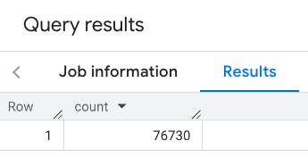
En basit PLACES_COUNT işlev çağrısı, coğrafi bölgedeki tüm yerlerin tek bir sayısını döndürür. Bu örnekte, Empire State binasının 1.000 metre yarıçapındaki tüm operasyonel yerlerin sayısını döndürüyorsunuz.
Bu örnekte, bir noktadan GEOGRAPHY değeri döndürmek için BigQuery ST_GEOGPOINT işlevi kullanılmaktadır.
SELECT`places_insights___us___sample.PLACES_COUNT`(JSON_OBJECT('geography',ST_GEOGPOINT(-73.9857,40.7484),-- Empire State Building'geography_radius',1000-- Radius in meters))ascount;
Yanıtta tek bir sayı var:
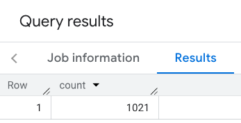
Daha tipik bir çağrı, arama alanına filtreler uygular. Sonraki örnekte, aramayı yalnızca aşağıdakilerin sayısını döndürecek şekilde sınırlamak için filtreler kullanılmaktadır:
Minimum puanı 3 olan restaurant türündeki yerler
Ucuz veya orta fiyat seviyesi
Şu anda çalışır durumda
Köpek kabul ediliyor
SELECT`places_insights___us___sample.PLACES_COUNT`(JSON_OBJECT('geography',ST_GEOGPOINT(-73.9857,40.7484),-- Empire State Building'geography_radius',1000,-- Radius in meters'types',["restaurant"],'min_rating',3,'price_level',['PRICE_LEVEL_INEXPENSIVE','PRICE_LEVEL_MODERATE'],'business_status',['OPERATIONAL'],'allows_dogs',TRUE))ascount;
Filtrelenmiş yanıt:
Yer veri kümesi sorgularında minimum 5 öğe eşiğinin zorunlu olduğunu unutmayın. Yer sayısı işlevlerinin avantajlarından biri, 0 dahil olmak üzere herhangi bir sayıyı döndürebilmeleridir. Örneğin, aşağıdaki çağrı 1 sayısını döndürür:
SELECT`places_insights___us___sample.PLACES_COUNT`(JSON_OBJECT('geography',ST_GEOGPOINT(-73.9857,40.7484),-- Empire State Building'geography_radius',500,-- Radius in meters'types',["restaurant"],'min_rating',4.0,'free_parking_lot',TRUE,'good_for_watching_sports',TRUE))ascount;
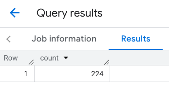
Örnek: Çokgen kullanarak restoran sayısını hesaplama
Arama alanını belirtmek için poligon kullanabilirsiniz. Çokgen kullanırken çokgenin noktaları kapalı bir döngü tanımlamalıdır. Bu döngüde çokgendeki ilk nokta son noktayla aynı olmalıdır.
Bu örnekte, bir poligondan GEOGRAPHY değeri döndürmek için BigQuery
ST_GEOGFROMTEXT
işlevi kullanılmaktadır.
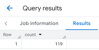
Örnek: Bir çizgiyi kullanarak restoran sayısını hesaplama
Bir sonraki örnekte, arama alanını, çizginin etrafında 100 metre arama yarıçapına sahip, bağlı noktalardan oluşan bir çizgi kullanarak tanımlıyorsunuz.
Çizgi, Routes API tarafından hesaplanan bir seyahat rotasına benzer. Rota bir araç, bisiklet
veya yaya için olabilir:
DECLAREgeoGEOGRAPHY;SETgeo=ST_GEOGFROMTEXT('LINESTRING(-73.98903537033028 40.73655649223003,-73.93580216278471 40.80955538843361)');-- NYC lineSELECT`places_insights___us___sample.PLACES_COUNT`(JSON_OBJECT('geography',geo,-- line'geography_radius',100,-- Radius around line'types',["restaurant"],'min_rating',1.0,'max_rating',4.5,'min_user_rating_count',1,'max_user_rating_count',10000,'price_level',['PRICE_LEVEL_INEXPENSIVE','PRICE_LEVEL_MODERATE'],'business_status',['OPERATIONAL'],'allows_dogs',TRUE))ascount;
Satırın yanıtı:
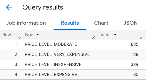
Örnek: Birden fazla çağrının sonuçlarını birleştirme
PLACES_COUNT işlevine yapılan birden fazla çağrının sonuçlarını birleştirebilirsiniz.
Örneğin, belirli bir bölgedeki aşağıdaki fiyat seviyelerine sahip restoran sayısını gösteren tek bir sonuç istiyorsunuz:
PRICE_LEVEL_INEXPENSIVE
PRICE_LEVEL_MODERATE
PRICE_LEVEL_EXPENSIVE
PRICE_LEVEL_VERY_EXPENSIVE"
Bu örnekte, her fiyat düzeyi için PLACES_COUNT işlevini çağırmak üzere bir döngü oluşturur ve her çağrının sonuçlarını geçici bir tabloya eklersiniz. Ardından, sonuçları görüntülemek için geçici tabloyu sorgularsınız:
-- Create a temp table to hold the results.CREATETEMPTABLEresults(typeSTRING,countINT64);-- Create a loop that calls PLACES_COUNT for each price level.FORtypesIN(SELECTtypeFROMUNNEST(["PRICE_LEVEL_INEXPENSIVE","PRICE_LEVEL_MODERATE","PRICE_LEVEL_EXPENSIVE","PRICE_LEVEL_VERY_EXPENSIVE"])astype)DOINSERTINTOresultsVALUES(types.type,`places_insights___us___sample.PLACES_COUNT`(JSON_OBJECT('types',["restaurant"],'geography',ST_GEOGPOINT(-73.9857,40.7484),-- Empire State Building'geography_radius',1000,-- Radius in meters'business_status',['OPERATIONAL'],'price_level',[types.type])));ENDFOR;-- Query the table of results.SELECT*FROMresults;
Birleştirilmiş yanıt:
Başka bir seçenek de birden fazla SELECT ifadesinin sonuçlarını birleştirmek için UNION ALL komutunu kullanmaktır. Aşağıdaki örnekte, önceki örnekteki sonuçlar gösterilmektedir:
SELECT"PRICE_LEVEL_INEXPENSIVE"asprice_level,`places_insights___us___sample.PLACES_COUNT`(JSON_OBJECT('types',["restaurant"],'geography',ST_GEOGPOINT(-73.9857,40.7484),-- Empire State Building'geography_radius',1000,-- Radius in meters'business_status',['OPERATIONAL'],'price_level',['PRICE_LEVEL_INEXPENSIVE']))ascountUNIONALLSELECT"PRICE_LEVEL_MODERATE"asprice_level,`places_insights___us___sample.PLACES_COUNT`(JSON_OBJECT('types',["restaurant"],'geography',ST_GEOGPOINT(-73.9857,40.7484),-- Empire State Building'geography_radius',1000,-- Radius in meters'business_status',['OPERATIONAL'],'price_level',['PRICE_LEVEL_MODERATE']))ascountUNIONALLSELECT"PRICE_LEVEL_EXPENSIVE"asprice_level,`places_insights___us___sample.PLACES_COUNT`(JSON_OBJECT('types',["restaurant"],'geography',ST_GEOGPOINT(-73.9857,40.7484),-- Empire State Building'geography_radius',1000,-- Radius in meters'business_status',['OPERATIONAL'],'price_level',['PRICE_LEVEL_EXPENSIVE']))ascountUNIONALLSELECT"PRICE_LEVEL_VERY_EXPENSIVE"asprice_level,`places_insights___us___sample.PLACES_COUNT`(JSON_OBJECT('types',["restaurant"],'geography',ST_GEOGPOINT(-73.9857,40.7484),-- Empire State Building'geography_radius',1000,-- Radius in meters'business_status',['OPERATIONAL'],'price_level',['PRICE_LEVEL_VERY_EXPENSIVE']))ascount
[[["Anlaması kolay","easyToUnderstand","thumb-up"],["Sorunumu çözdü","solvedMyProblem","thumb-up"],["Diğer","otherUp","thumb-up"]],[["İhtiyacım olan bilgiler yok","missingTheInformationINeed","thumb-down"],["Çok karmaşık / çok fazla adım var","tooComplicatedTooManySteps","thumb-down"],["Güncel değil","outOfDate","thumb-down"],["Çeviri sorunu","translationIssue","thumb-down"],["Örnek veya kod sorunu","samplesCodeIssue","thumb-down"],["Diğer","otherDown","thumb-down"]],["Son güncelleme tarihi: 2025-09-06 UTC."],[],[],null,["The `PLACES_COUNT` function returns a single count value of places based on the\nspecified search area and search filters. You must specify the search area to\nthe `PLACES_COUNT` function and can optionally specify additional filter\nparameters, such as place type, operating status, price level, and more.\n\nBecause the `PLACES_COUNT` function returns a single value, call it using\na `SELECT` clause.\n\n- Input parameters:\n\n - **Required** : The `geography` [filter parameter](/maps/documentation/placesinsights/experimental/filter-params) that\n specifies the search area. The `geography` parameter takes a value defined\n by the BigQuery\n [`GEOGRAPHY`](https://cloud.google.com/bigquery/docs/reference/standard-sql/data-types#geography_type)\n data type, which supports points, linestrings, and polygons.\n\n - **Optional** : Additional [filter](/maps/documentation/placesinsights/experimental/filter-params) parameters to refine your\n search.\n\n- Returns:\n\n - A single `count` value as an `INT64`.\n\nExample: Calculate the number of places in a search radius\n\nThe simplest `PLACES_COUNT` function call returns a single count of all places\nin a geographical area. In this example, you return the count of all operational\nplaces within 1000 meters of the Empire State building.\n\nThis example uses the BigQuery\n[`ST_GEOGPOINT`](https://cloud.google.com/bigquery/docs/reference/standard-sql/geography_functions#st_geogpoint)\nfunction to return a `GEOGRAPHY` value from a point. \n\n```googlesql\nSELECT `maps-platform-analytics-hub.sample_places_insights_us.PLACES_COUNT`(\n JSON_OBJECT(\n 'geography', ST_GEOGPOINT(-73.9857, 40.7484), -- Empire State Building\n 'geography_radius', 1000 -- Radius in meters\n )\n) as count;\n```\n\nThe response contains a single count:\n\nA more typical call applies filters to the search area. The next example uses\nfilters to limit the search to only return a count of:\n\n- Places of type `restaurant` with the minimum rating of 3\n- A price level of inexpensive or medium\n- Currently operational\n- Allows dogs\n\n```googlesql\nSELECT `maps-platform-analytics-hub.sample_places_insights_us.PLACES_COUNT`(\n JSON_OBJECT(\n 'geography', ST_GEOGPOINT(-73.9857, 40.7484), -- Empire State Building\n 'geography_radius', 1000, -- Radius in meters\n 'types', [\"restaurant\"],\n 'min_rating', 3,\n 'price_level', ['PRICE_LEVEL_INEXPENSIVE', 'PRICE_LEVEL_MODERATE'],\n 'business_status', ['OPERATIONAL'],\n 'allows_dogs', TRUE\n )\n) as count;\n```\n\nThe filtered response:\n\nRemember that place dataset queries enforce a minimum count threshold of\n5. One of the advantages of the place count functions is\nthat they can return any counts, including 0. For example, the following call\nreturns a count of 1: \n\n```googlesql\nSELECT `maps-platform-analytics-hub.sample_places_insights_us.PLACES_COUNT`(\n JSON_OBJECT(\n 'geography', ST_GEOGPOINT(-73.9857, 40.7484), -- Empire State Building\n 'geography_radius', 500, -- Radius in meters\n 'types', [\"restaurant\"],\n 'min_rating', 4.0,\n 'free_parking_lot', TRUE,\n 'good_for_watching_sports', TRUE\n )\n) as count;\n```\n\nExample: Calculate the number of restaurants using a polygon\n\nYou can use a polygon to specify the search area. When using a polygon,\nthe points of the polygon must define a closed loop where the first point in the\npolygon is the same as the last point.\n\nThis example uses the BigQuery\n[`ST_GEOGFROMTEXT`](https://cloud.google.com/bigquery/docs/reference/standard-sql/geography_functions#st_geogfromtext)\nfunction to return a `GEOGRAPHY` value from a polygon. \n\n```googlesql\nDECLARE geo GEOGRAPHY;\nSET geo = ST_GEOGFROMTEXT('''POLYGON((-73.985708 40.75773,-73.993324 40.750298,\n -73.9857 40.7484,-73.9785 40.7575,\n -73.985708 40.75773))'''); -- NYC viewport\n\nSELECT `maps-platform-analytics-hub.sample_places_insights_us.PLACES_COUNT`(\n JSON_OBJECT(\n 'geography',geo, -- viewport \n 'types', [\"restaurant\"],\n 'min_rating', 1.0,\n 'max_rating', 4.5,\n 'min_user_rating_count', 1,\n 'max_user_rating_count', 10000,\n 'price_level', ['PRICE_LEVEL_INEXPENSIVE', 'PRICE_LEVEL_MODERATE'],\n 'business_status', ['OPERATIONAL'],\n 'allows_dogs', TRUE\n )\n) as count;\n```\n\nThe response for the viewport:\n\nExample: Calculate the number of restaurants using a line\n\nIn the next example, you define the search area using a line of connected\npoints with a search radius of 100 meters around the line.\nThe line is similar to a travel route calculated by the [Routes\nAPI](/maps/documentation/routes). The route might be for a vehicle, a bicycle,\nor for a pedestrian: \n\n```googlesql\nDECLARE geo GEOGRAPHY;\nSET geo = ST_GEOGFROMTEXT('LINESTRING(-73.98903537033028 40.73655649223003,-73.93580216278471 40.80955538843361)'); -- NYC line\n\nSELECT `maps-platform-analytics-hub.sample_places_insights_us.PLACES_COUNT`(\n JSON_OBJECT(\n 'geography',geo, -- line\n 'geography_radius', 100, -- Radius around line\n 'types', [\"restaurant\"],\n 'min_rating', 1.0,\n 'max_rating', 4.5,\n 'min_user_rating_count', 1,\n 'max_user_rating_count', 10000,\n 'price_level', ['PRICE_LEVEL_INEXPENSIVE', 'PRICE_LEVEL_MODERATE'],\n 'business_status', ['OPERATIONAL'],\n 'allows_dogs', TRUE\n )\n) as count;\n```\n\nThe response for the line:\n\nExample: Combine the results of multiple calls\n\nYou can combine the results of multiple calls to the `PLACES_COUNT` function.\nFor example, you want a single result showing the number of restaurants for\nthe following price levels within a specific area:\n\n- `PRICE_LEVEL_INEXPENSIVE`\n- `PRICE_LEVEL_MODERATE`\n- `PRICE_LEVEL_EXPENSIVE`\n- `PRICE_LEVEL_VERY_EXPENSIVE\"`\n\nIn this example, you create a loop to call the `PLACES_COUNT` function for each\nprice level, and insert the results of each call to a temporary table. You then\nquery the temporary table to display the results: \n\n```googlesql\n-- Create a temp table to hold the results.\nCREATE TEMP TABLE results (type STRING, count INT64);\n\n-- Create a loop that calls PLACES_COUNT for each price level.\nFOR types IN (SELECT type FROM UNNEST([\"PRICE_LEVEL_INEXPENSIVE\", \"PRICE_LEVEL_MODERATE\", \"PRICE_LEVEL_EXPENSIVE\", \"PRICE_LEVEL_VERY_EXPENSIVE\"]) as type)\nDO\n INSERT INTO results VALUES (types.type, `maps-platform-analytics-hub.sample_places_insights_us.PLACES_COUNT`(\n JSON_OBJECT(\n 'types', [\"restaurant\"],\n 'geography', ST_GEOGPOINT(-73.9857, 40.7484), -- Empire State Building\n 'geography_radius', 1000, -- Radius in meters\n 'business_status', ['OPERATIONAL'],\n 'price_level', [types.type]\n )));\nEND FOR;\n\n-- Query the table of results.\nSELECT * FROM results;\n```\n\nThe combined response:\n\nAnother option is to use the `UNION ALL` command to combine the results of\nmultiple `SELECT` statements. The following example shows the same results as\nfrom the previous example: \n\n```googlesql\nSELECT \"PRICE_LEVEL_INEXPENSIVE\" as price_level, `maps-platform-analytics-hub.sample_places_insights_us.PLACES_COUNT`(\n JSON_OBJECT(\n 'types', [\"restaurant\"],\n 'geography', ST_GEOGPOINT(-73.9857, 40.7484), -- Empire State Building\n 'geography_radius', 1000, -- Radius in meters\n 'business_status', ['OPERATIONAL'],\n 'price_level', ['PRICE_LEVEL_INEXPENSIVE']\n )\n) as count\n\nUNION ALL\n\nSELECT \"PRICE_LEVEL_MODERATE\" as price_level, `maps-platform-analytics-hub.sample_places_insights_us.PLACES_COUNT`(\n JSON_OBJECT(\n 'types', [\"restaurant\"],\n 'geography', ST_GEOGPOINT(-73.9857, 40.7484), -- Empire State Building\n 'geography_radius', 1000, -- Radius in meters\n 'business_status', ['OPERATIONAL'],\n 'price_level', ['PRICE_LEVEL_MODERATE']\n )\n) as count\n\nUNION ALL\n\nSELECT \"PRICE_LEVEL_EXPENSIVE\" as price_level, `maps-platform-analytics-hub.sample_places_insights_us.PLACES_COUNT`(\n JSON_OBJECT(\n 'types', [\"restaurant\"],\n 'geography', ST_GEOGPOINT(-73.9857, 40.7484), -- Empire State Building\n 'geography_radius', 1000, -- Radius in meters\n 'business_status', ['OPERATIONAL'],\n 'price_level', ['PRICE_LEVEL_EXPENSIVE']\n )\n) as count\n\nUNION ALL\n\nSELECT \"PRICE_LEVEL_VERY_EXPENSIVE\" as price_level, `maps-platform-analytics-hub.sample_places_insights_us.PLACES_COUNT`(\n JSON_OBJECT(\n 'types', [\"restaurant\"],\n 'geography', ST_GEOGPOINT(-73.9857, 40.7484), -- Empire State Building\n 'geography_radius', 1000, -- Radius in meters\n 'business_status', ['OPERATIONAL'],\n 'price_level', ['PRICE_LEVEL_VERY_EXPENSIVE']\n )\n) as count\n```"]]